Kirthar Mountains
| Kirthar Mountains | |
|---|---|
| Arbiti Mountains[1] | |
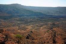
 View of the Kirthar National Park, one of the major wildlife reserves in Sindh. |

The Kirthar Mountains (Urdu: كوه کیر تھر) (Sindhi: کير ٿر جبل) are a mountain range located in the Pakistani provinces of Balochistan and Sindh. The mountains extend southward for about 190 mi (310 km) from the Mula River in east-central Balochistan to Cape Monze on the Arabian Sea. The Kirthar Mountains form the boundary between the lower Indus Plain (to the east) and southern Balochistan (to the west). It consists of a series of parallel rock hill ridges rising from 4,000 ft (1,200 m) in the south to nearly 8,000 ft (2,400 m) in the north.

The maximum elevation in the Sindh segment of the mountains was reported in April 2009, as 7,056 ft (2,151 m) above sea-level. An old map, by the British Army Corps of Engineers, calls it Barugh Hill, along with a surveyed height of 7,122 ft (2,171 m). Barugh, means "big fat mountain" in the Brahui language, the language of the Sasoli tribe, who still live in that area. Barough is a branch of the Kirthar mountains, off Dadu, and the highest mountain peak of Sindh, situated a few miles north-west of the upcoming Gorakh Hill Station, at 5,688 ft (1,734 m) from sea level. The next highest is a 6,880 ft (2,100 m) high peak, known locally as Kutte-di-Kabar (Dog's Grave). There are also a number of other peaks in the Sindh segment of the Kirthar Mountains exceeding 5,500 ft (1,700 m); these all receive occasional snowfall during the winter rains.

Kirthar has a simple mountain structure of the regular anticlinal type, with the arches steepest towards the north and the west and gently dipping towards the south and the valley of the Indus. The inhabitants of the Kirthar Mountains are chiefly Brahui, Sindhi, and Baloch tribes, on both sides, who subsist by flock grazing. Major Baloch tribes of Kirthar are Burfat, Gabol, Marri, Bozdar, Lund, Nohani, Bugti, Lashari, and others.
See also
References
External links
Coordinates: 27°00′00″N 67°09′20″E / 27.0000°N 67.1556°E