Kirkjubøur
| Kirkjubøur | |
|---|---|
| Village | |
|
At left is Saint Olav's Church from the 12th century. The central building is Kirkjubøargarður (also called Roykstovan), the worlds' oldest still inhabited wooden house, from the 11th century. It's also a museum. In the background the islands Sandoy and Hestur. | |
 Kirkjubøur Location in the Faroe Islands | |
| Coordinates: 61°57′22″N 6°47′37″W / 61.95611°N 6.79361°WCoordinates: 61°57′22″N 6°47′37″W / 61.95611°N 6.79361°W | |
| State |
|
| Constituent country |
|
| Island | Streymoy |
| Municipality | Tórshavn Municipality |
| Population (1 January 2009) | |
| • Total | 75 |
| Time zone | GMT |
| • Summer (DST) | EST (UTC+1) |
| Postal code | FO 175 |
| Climate | Cfc |
.jpg)
.jpg)
Kirkjubøur (Danish: Kirkebø) is the southernmost village on Streymoy, Faroe Islands and the country's most important historical site with the ruins of the Magnus Cathedral from around 1300, the Saint Olav's Church from 12th century and the old farmhouse Kirkjubøargarður from 11th century. In 1832 a runestone was found near the Magnus Cathedral in Kirkjubøur. The stone which is referred to as the Kirkjubøur stone dates back to the Viking Ages.
The village is located on the south-west coast of Streymoy and has a view towards the islands Hestur and Koltur towards west and to Sandoy towards south.
The little islet just of the coast, Kirkjubøhólmur contains an eiderduck colony.
To the village belongs the islet Trøllhøvdi, just 100 m of the northern tip of Sandoy 9 km away from Kirkjubø, it was given as payment to the villagers as it was their duty to ferry people across to Sandoy in medieval times.
History
The village was important in the Middle Ages. At that time it was the episcopal residence for the Diocese of the Faroe Islands and as such the spiritual centre of the society. In those days the village is said to have had around 50 houses. The majority of these houses were washed away by a fierce storm in the 16th century, which created the islet Kirkjubøhólmurin, which contains ruins from that time.
It is speculated that the church located the diocese in Kirkjubø, to counter the heathen Vé in Velbastaður only 5 km to the north west up the coast.[1]
There are three main attractions from this time:
- The ruins of the Magnus Cathedral from about 1300.
- The oldest still used church of the Faroes, Saint Olav's Church from 12th century.
- The oldest still inhabited wooden house of the world, Kirkjubøargarður from 11th century.
People
Many prominent people come from Kirkjubøur or have been living here:
- Sverre I of Norway (1151–1202), grew up here.
- Bishop Erlendur (?-1308), who built the Magnus Cathedral and wrote the Sheep letter, the oldest document of the country.
- Súsanna Helena Patursson (1864–1916), first feminist of the Faroes.
- Jóannes Patursson (1866–1946), nationalist leader and writer.
- Sverri Patursson (1871–1960), writer, journalist and environmentalist.
- Erlendur Patursson (1913–1986), writer and nationalist politician.
- Tróndur Patursson (b. 1944), artist and adventurer.
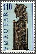
Kirkjubøur pew ends
The mediaeval carved pew ends from Saint Olav's church are now to be found in the National Museum of the Faroe Islands. These featured in three series of Faroese stamps, engraved by Czeslaw Slania. For the full series, see here.
See also
References
- ↑ Ljunggren, Karl Gustaf (1955-01-01). "Kirkjubøur, Velbstaður og Tórshavn". Fróðskaparrit 1955.
External links
- Faroeislands.dk: Kirkjubøur Images and description of all cities on the Faroe Islands.
|


.jpg)
.jpg)
| Wikimedia Commons has media related to Kirkjubøur. |