Kinmen Airport
| Kinmen Airport (Kinmen Shang Yi Airport) 金門航空站 金門尚義機場 Jīnmén Hángkōngzhàn Jīnmén Shàngyì Jīchǎng | |||||||||||
|---|---|---|---|---|---|---|---|---|---|---|---|
 | |||||||||||
| IATA: KNH – ICAO: RCBS | |||||||||||
| Summary | |||||||||||
| Airport type | Public | ||||||||||
| Operator | Civil Aeronautics Administration | ||||||||||
| Serves | Kinmen | ||||||||||
| Location | Jinhu, Kinmen, Fujian, Republic of China | ||||||||||
| Elevation AMSL | 93 ft / 28 m | ||||||||||
| Coordinates | 24°25′40″N 118°21′33″E / 24.42778°N 118.35917°ECoordinates: 24°25′40″N 118°21′33″E / 24.42778°N 118.35917°E | ||||||||||
| Map | |||||||||||
 KNH Location of airport in the Republic of China | |||||||||||
| Runways | |||||||||||
| |||||||||||
Kinmen Airport or Shang Yi Airport (Chinese: 金門尚義機場; Chinese: 金门尚义机场; pinyin: Jīnmén Shàngyì Jīchǎng; Pe̍h-ōe-jī: Kim-mn̂g Siōng-gī Ki-tiû) (IATA: KNH, ICAO: RCBS) is a civilian airport serving Kinmen, Fujian Province, Republic of China.[1] It is located at Jinhu Township of Kinmen County. It was authorized to become a C-class airport under the direct supervision of Civil Aeronautics Administration, Ministry of Transport and Communications of the Executive Yuan.
It serves an average of 1.2 million passenger every year.
With the direct Cross-Strait flights between mainland China and Taiwan being expensive compared to domestic fares for each side respectively. This makes travel via Kinmen with an hourly short thirty-minute ferry ride to Xiamen's Wutong Ferry Terminal, close to Xiamen Gaoqi International Airport, very popular. Check-in facilities for Kinmen Airport flights exists within the Wutong Ferry Terminal to assist in travel from the mainland to Taiwan.
History
Kinmen Airport was originally established in 1949 in Sihung Village. In June 1951, the Ministry of National Defense ratified TransAsia Airways to launch its first flight to Kinmen and a once-a-week scheduled flight began to operate. On 23 August 1958, the flight was cancelled due to Second Taiwan Strait Crisis with the People's Liberation Army (PLA). The airport was then moved to Shang-i where it is now located, taken over by the Republic of China Air Force (ROCAF) in consideration of the war with PLA.
With the growing number of passengers traveling between Taiwan Island and Kinmen, the government started to reestablish the civilian flight between the two and it began operation in September 1987 by Far Eastern Air Transport, sharing the same apron and terminal building with ROCAF at the airport. Since then, the new era of civilian flight to Kinmen began. Many other airlines joined the flight route.
Taking the necessary steps to accommodate the passenger growth to Kinmen, the Civil Aeronautics Administration (CAA) coordinated with the government for general construction plan of NT$1.5 billion and built a new civilian airport at the northeastern side of the military airport. On 1 March 1994, the Kinmen Civil Airport was formally established, aiming at providing much more safety, convenience and comfort for the passengers and promoting the progress and prosperity of Kinmen. On 3 March 2000, the CAA implemented improvements of facilities, flight security and quality of service at the airport.[3]
Facilities
The airport resides at an elevation of 93 feet (28 m) above mean sea level. It has one runway designated 06/24 with an asphalt surface measuring 3,001 by 45 metres (9,846 ft × 148 ft).[1]
A 2,580-metre connecting road links to a highway leading to two townships.
Airlines and destinations
| Airlines | Destinations |
|---|---|
| Far Eastern Air Transport | Kaohsiung, Taichung, Taipei-Songshan |
| Mandarin Airlines | Taichung, Taipei-Songshan |
| Uni Air | Chiayi, Kaohsiung, Taichung, Tainan, Taipei-Songshan |
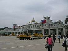
| Kinmen Airport | ||||||||||
|---|---|---|---|---|---|---|---|---|---|---|
| ||||||||||
| Airport and surrounds |


See also
| Wikimedia Commons has media related to Kinmen Airport. |
References
- 1 2 3 Airport information for RCBS from DAFIF (effective October 2006)
- ↑ Airport information for KNH at Great Circle Mapper. Source: DAFIF (effective October 2006).
- ↑ http://www.kma.gov.tw/English/Introduction/1.aspx
External links
- Official Website in Traditional Chinese
- Official website in English
- Accident history for KNH at Aviation Safety Network