Kingston near Lewes
| Kingston near Lewes | |
.jpg) Original Ashcombe Mill |
|
 Kingston near Lewes |
|
| Area | 5.7 km2 (2.2 sq mi) [1] |
|---|---|
| Population | 831 (2011)[2] |
| – density | 383/sq mi (148/km2) |
| OS grid reference | TQ394083 |
| – London | 45 miles (72 km) N |
| District | Lewes |
| Shire county | East Sussex |
| Region | South East |
| Country | England |
| Sovereign state | United Kingdom |
| Post town | LEWES |
| Postcode district | BN7 |
| Dialling code | 01273 |
| Police | Sussex |
| Fire | East Sussex |
| Ambulance | South East Coast |
| EU Parliament | South East England |
| UK Parliament | Lewes |
| Website | Kingston PC |
|
|
Coordinates: 50°52′N 0°01′W / 50.86°N 0.02°W
Kingston near Lewes is a village and civil parish in the Lewes District of East Sussex, England. The village is mentioned in the Domesday Book and is located two miles (3.2 km) south of Lewes on the slopes of the South Downs.
Overview
The village is small and situated at the base of the South Downs. Features include the primary school, village hall, riding stables, and the local pub The Juggs, which is housed in a 14th-century cottage and now leased to the Kentish brewer Shepherd Neame. The pub and Juggs Lane (a road used as a public path which runs by it), are named after the fish-carrying baskets used by Brighton fishwives on their way through Kingston to the market at Lewes. The path may still be traversed by foot, but is unsuitable for vehicles (though legal for them), and continues almost to Brighton.
Many of the older houses are in the original village centre, "The Street", a picturesque mixture of cottages and larger farmhouses that leads past St Pancras Church and the village pound, where stray sheep were once kept, to the South Downs Way.
During the 1930s to 1950s, a number of substantial houses were built on Kingston Ridge and in the early 1960s orchard land was developed to form what is known locally as "the estate", family houses that helped serve the establishment of the University of Sussex at that time. During the construction of the estate, a new village green, St. Pancras Green, was built. It features tennis courts and a cricket ground, and in summer supports occasional rounds of the traditional Sussex game of stoolball. The radical reputation of the university influx earned this new green the nickname "Red Square" from some of the more traditional locals.
The Prime Meridian passes to the east of Kingston near Lewes.
Governance
At a local level Kingston is governed by Kingston Parish Council. Its responsibilities include footpaths, playgrounds and minor planning applications. The parish council has seven seats available which were uncontested in the May 2007 election.[3]
The next level of government is the district council. The parish of Kingston lies within the Kingston ward of Lewes District Council, which returns a single seat to the council. The election on 4 May 2007 elected a Liberal Democrat.[4] This ward stretches south to Piddinghoe and had a total population of 2,106 as of the 2011 Census.[5]
East Sussex County Council is the next tier of government, for which Kingston is within the Newhaven and Ouse Valley West division, with responsibility for Education, Libraries, Social Services, Civil Registration, Trading Standards and Transport. Elections for the County Council are held every four years. The Liberal Democrat David Rogers OBE was elected in the 2005 election.[6]
The UK Parliament constituency for Kingston is Lewes. The Conservative MP is Maria Caulfield who in 2015 replaced the Liberal Democrat Norman Baker, who had been constituency MP since 1997.
At European level, Kingston is represented by the South-East region, which holds ten seats in the European Parliament. The June 2004 election returned 4 Conservatives, 2 Liberal Democrats, 2 UK Independence, 1 Labour and 1 Green, none of whom live in East Sussex.[7]
Landmarks
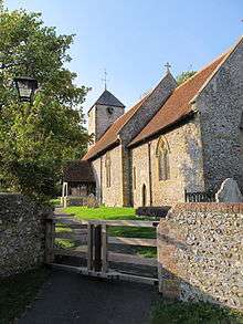
- The Norman parish St Pancras Church is dedicated to St. Pancras and has a distinctive Tapsel gate, with a central pivot which locals believe was designed to make it easy for funeral bearers to pass either side.[8][9]
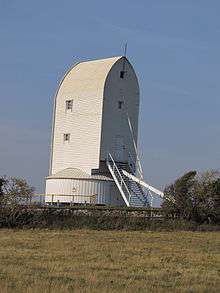
- Above Kingston, to the east of the village, stood Ashcombe Mill, a six-sailed post mill which collapsed in 1916. Planning permission was granted for the construction of a replica of the mill for residential purposes on the original site,[10] which has since been built.
- Westward of the village the land rises to a height of over 600 feet (180 m) at Kingston Hill and Newmarket Hill.[11]
- Castle Hill, a Site of Special Scientific Interest, lies within the parish. The site, which extends into the Brighton district, is listed as of biological interest because of its habitat of chalk grassland. Early spider-orchid and the wart-biter (a bush cricket) are two nationally rare species that are found here.[12]
References
- ↑ "East Sussex in Figures". East Sussex County Council. Retrieved 26 April 2008.
- ↑ "Civil Parish population 2011". Retrieved 12 October 2015.
- ↑ "Results – Town and Parish Council Elections" (PDF). Lewes District Council. 3 May 2007. Retrieved 24 September 2008.
- ↑ "Election Results". Lewes District Council. 4 May 2007. Archived from the original on 18 September 2008. Retrieved 15 November 2008.
- ↑ "Ward population 2011". Retrieved 12 October 2015.
- ↑ "Councillor David Rogers OBE". Find your Councillor. East Sussex County Council. Retrieved 15 November 2008.
- ↑ "UK MEPs". UK Office of the European Parliament. Archived from the original on 17 September 2007. Retrieved 19 September 2007.
- ↑ Roberts, William J. (1950). "Tapsel: His gate". Sussex County Magazine. Retrieved 21 September 2008.
- ↑ John Houghton (2000), The Parish Church of St. Pancras. Kingston-Near-Lewes, Kingston Parochial Church Council
- ↑ "Kingston, Near Lewes". Sussex Mills Group. Retrieved 18 October 2008.
- ↑ "Parishes, Kingston near Lewes". British History Online. Retrieved 8 September 2011.
- ↑ "Natural England – SSSI". English Nature. Retrieved 19 June 2008.
External links
| Wikimedia Commons has media related to Kingston near Lewes. |