Kingsley Dam
| Kingsley Dam | |
|---|---|
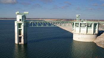 The outlet tower structure attached to Kingsley Dam used to release water from Lake McConaughy | |
| Country | United States |
| Location | Keith County, Nebraska |
| Coordinates | 41°13′23″N 101°40′20″W / 41.22306°N 101.67222°WCoordinates: 41°13′23″N 101°40′20″W / 41.22306°N 101.67222°W |
| Opening date | 1941 |
| Dam and spillways | |
| Height | 162 feet (49 m) |
| Length | 3.1 miles (5.0 km) |
| Width (base) | 1,100 feet (340 m) |
| Spillways | Morning Glory Spillway |
| Reservoir | |
| Creates | Lake McConaughy |
| Total capacity | 1,740,000 acre feet (2.15 km3) |
| Catchment area | North Platte River |
| Max. water depth | 142 ft (43 m) |
Kingsley Dam is located on the east side of Lake McConaughy in central Keith County, Nebraska, and is the second largest hydraulic fill dam in the world.[1] It was built as part of the New Deal project.[2] The dam is 162 feet (49 m) tall, 3.1 miles (5.0 km) long, and 1,100 feet (340 m) wide at its base. On the east side of the dam is Lake Ogallala and on the south side is the Kingsley Hydroelectricity Plant. The Nebraska Game and Parks Commission and Central Nebraska Public Power and Irrigation District are also located in this area. Kingsley Dam, the Kingsley Hydroelectricity Plant, the Morning Glory Spillway, and the Outlet Tower – a large structure near the dam used to release water from the lake – are main visual icons of Lake McConaughy.
References
- ↑ "History and Facts about Lake McConaughy". Official Website of the Ogallala/Keith County Chamber of Commerce. Retrieved September 5, 2009.
- ↑ "A Brief History of the Central Nebraska Public Power and Irrigation District". The Central Nebraska Public Power and Irrigation District Website. Retrieved September 5, 2009.