King Street, Melbourne
| King Street Victoria | |
|---|---|
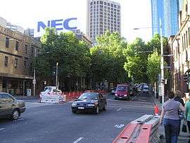 | |
| King Street, facing north from Flinders St | |
| General information | |
| Type | Street |
| Length | 2 km (1.2 mi) |
| Route number(s) |
|
| Former route number |
|
| Major junctions | |
| NW end |
North Melbourne |
| SE end |
Southbank |
| Location(s) | |
| Suburb(s) | Melbourne CBD |
| |
King Street is a main street in the Melbourne central business district. King Street was part of National Route 1 and 79 until the city by-pass road linking the Monash Freeway with the Westgate Freeway was completed. The street is named after Phillip Gidley King, Governor of New South Wales.[1]
King Street begins at Flinders Street, continues through the Melbourne CBD and ends at the intersection of Hawke and Victoria Streets in West Melbourne, Victoria.
King Street is considered a hub of Melbourne's nightlife, and is home to many nightclubs, topless bars and restaurants. King Street is also home to Victoria University's City King St campus. Towards the northern end of King Street are the Flagstaff Gardens.
Buildings and architecture
In terms of architecture, there are many notable buildings on the street. The street crosses Melbourne's financial heart and many of Melbourne's tallest office towers line either side of the street, especially between Collins and Bourke Streets. The area was once lined with bluestone warehouses, some examples of which still exist to this day. The street has many examples of modern architecture, some designed by Yuncken Freeman who also had their offices located on the street.

The street is home to St James Old Cathedral, an Anglican church, although it is not the church's original site. It was relocated from originally stood near the corner of Collins Street and William Street in 1914. Lazar Restaurant (numbers 234-238), a three storey bluestone warehouse built in 1858 is one of Melbourne's oldest and is heritage registered. Other fine examples of historic three story 1890s buildings can be found at 121 King Street (corner of King and Little Collins) and the Australian Institute of Music's Melbourne campus (number 120). Once a storage facility for Ferguson's Winery, today it is home to Envato.[2] The Former New Zealand Mercantile building (1909), one of Melbourne's rare unusual Edwardian buildings is on the corner of King and Collins opposite the Rialto Towers (1986) once Melbourne's tallest. The Melbourne Stock Exchange (1990), another large post modern glass tower is on the opposite corner. Among the notable demolitions on the street are the Federal Coffee Palace (1888-1972) and Robb's Buildings (1885), which made way for the Rialto Towers, both on the corner of King and Collins, with its observation deck with views over Southbank, Docklands, and Port Phillip Bay.
Adult entertainment district
During the 1980s, the south end of King Street and in adjacent Flinders Street, 19th century warehouses were converted into night clubs.
King Street is Melbourne's main nightclub district and a mecca for strip bars. On Saturday nights the whole district is a mass of activity. Melbourne's largest clubs including "Clique Lounge Bar" (open late with a 24-hour Licence), Tramp, Inflation (Cloud Nine), La Di Da, Brown Alley & Sorry Grandma make up the key clubs along the strip which attract thousands of party goers over a weekend.
The street is also considered as the hub of Melbourne's adult entertainment including Opium Lounge,[3] Goldfingers, The Men's Gallery,[4] Dallas Dancers, Bar 20, Centrefold Lounge[5] and Spearmint Rhino.
Events
- The collapse of the new King Street Bridge on 10 July 1962.
See also
![]() Australian Roads portal
Australian Roads portal
References
- ↑ Street Names
- ↑ "Envato contact page". Envato Pty Ltd. Retrieved 5 July 2013.
- ↑ "Opium Lounge | Club Opium | 189 King Street Melbourne". opiumlounge.com.au. Retrieved 2016-02-01.
- ↑ The Men's Gallery
- ↑ Centrefold Lounge
Coordinates: 37°48′44″S 144°57′14″E / 37.8122°S 144.9538°E