King Frederick VI Coast
- Not to be confused with King Frederick VIII Land
| King Frederick VI Coast Kong Frederik VI Kyst | |
|---|---|
| Region | |
|
| |
| |
| Country | Greenland |
| Dimensions | |
| • Length | 590 km (370 mi) |
| Elevation | 800 m (2,600 ft) |
King Frederick VI Coast (Danish: Kong Frederik VI Kyst)[1] is a major geographic division of Greenland. It comprises the coastal area of Southeastern Greenland in Sermersooq and Kujalleq municipalities fronting the Irminger Sea of the North Atlantic Ocean.[2] It is bordered by King Christian IX Land on the north and the Greenland Ice Sheet to the west.
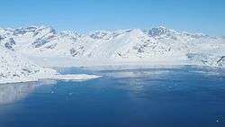
The King Frederick VI Coast stretches for about 590 km (370 mi) and is characterized by a succession of short fjords, steep mountains and small coastal islands. There is a narrow belt of ice-free land between the shore and the Inland ice cap, interrupted by active glaciers reaching the shore with the ice limit varying seasonally from year to year. Owing to the movement of pack ice in the area and frequent gale-force winds that sweep down from the Greenland ice cap, it is often difficult to approach or navigate along the coast by ship.[3]
History
This area was inhabited by the Inuit people in the past, but in present times King Frederick VI Coast is practically uninhabited. Numerous coastal islands, including Qulleq, Timmiarmiit and Skjoldungen, have Paleo-Eskimo or ancient Thule culture sites.[4]
The first European to reportedly have sighted the eastern coast of Greenland was Icelander Gunnbjørn Ulf-Krakason in the 10th century.[5]
In 1931 Gino Watkins, leader of the 1930-1931 British Arctic Air Route Expedition, together with Percy Lemon and Augustine Courtauld traveled southwards along the little explored King Frederick VI Coast all the way south on a gruesome open boat journey of 600 nautical miles (1,111 km). Braving harsh weather conditions, the three boats managed to round Cape Farewell, reaching finally Nanortalik on the western side. Watkins, Courtauld and Percy Lemon had made the dangerous trip on two small whaleboats and a kayak, a reckless venture that they were very lucky to survive.[6]
Geography
The coast extends from Pikiulleq Bay (former spelling 'Pikiutdleq') in the north to Cape Farewell in the south. Many sections of the shore area of King Frederick VI Coast are very indented with numerous fjords and bays, such as Lindenow Fjord (Kangerlussuatsiaq), Paatusoq, Anorituup Kangerlua, Timmiarmiut Fjord, Napasorsuaq Fjord, Bernstorff Fjord and Umivik Bay. There are numerous active glaciers at the head of the fjords, as well as many coastal islands, such as Upernattivik, Skjoldungen, Timmiarmiit, Queen Louise Island and Iluileq.
Fjords in the coast form peninsulas between them, the largest of which is Odinland. Most fjords are flanked by steep mountain ranges. The highest point in the coast is the magnificent Mount Paatusoq towering to a height of 2,488 m (8,163 ft) above the glacier at the head of the Paatusoq fjord.[7]
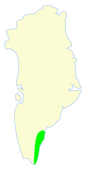 Limits of King Frederick VI Coast. |
 Satellite picture of King Frederick VI Coast. |
References
- ↑ "Kong Frederik VI Kyst". Mapcarta. Retrieved 24 April 2016.
- ↑ Mills, William J. Exploring Polar Frontiers: A Historical Encyclopedia, Volume 1. p. 349.
- ↑ Prostar Sailing Directions 2005 Greenland and Iceland Enroute, p. 99
- ↑ "Jensen, Jens Fog. Paleo-Eskimo sites in Skjoldungen District, South East Greenland". eHRAF Archaeology. Retrieved 18 April 2016.
- ↑ Spencer Apollonio, Lands That Hold One Spellbound: A Story of East Greenland, 2008 p. 7
- ↑ The sea canoeist newsletter - Kiwi Association of Sea Kayakers (KASK)
- ↑ Patuersoq, Greenland
External links
- Distribution Map of Archaeological, Historic, Cultural and Ancient Sites sites in Greenland
- New insights on the north-eastern part of the Ketilidian orogen in South-East Greenland