King Ezana's Stela

King Ezana's Stela is an obelisk in the ancient city of Axum, Ethiopia. It stands at the center of the Northern Stelae Park, which contains hundreds of smaller and less decorated stelae. This stela is probably the last one erected and the largest of those that remain unbroken. King Ezana's Stela stands 21 m (69 ft) tall, smaller than the collapsed 33 m (108 ft) Great Stela and the better-known 24 m (79 ft) "Obelisk of Axum" (reassembled and unveiled on September 4, 2008). It is decorated with a false door at its base, and apertures resembling windows on all sides.
History
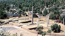
This monument, properly termed a stela (hawilt or hawilti in the local Afro-Asiatic language) was carved and erected in the 4th century by subjects of the Kingdom of Aksum, an ancient Ethiopian civilization. The stelae are thought to be "markers" for underground burial chambers. The largest grave markers were for royal burial chambers and were decorated with multi-story false windows and false doors; nobility would have smaller, less decorated stelae. King Ezana's Stela is likely to be the last example of this practice, which was abandoned after the Axumites adopted Christianity under King Ezana. Ezana was the first monarch of Axum to embrace the faith, following the teachings and examples of his childhood tutor, Frumentius. King Ezana's Stela is also the only one of the three major "royal" obelisks (the others being the Great Stela and the Obelisk of Axum) that was never broken.
In 2007–2008, during the reassembly of the Obelisk of Axum, which had been taken to Italy in 1937 and returned to Ethiopia in 2005,[1] King Ezana's Stela was structurally consolidated in by a team of engineers led by Giorgio Croci, Professor of Structural Problems of Monuments and Historical Buildings at Sapienza University of Rome.
See also
References
- ↑ Obelisk arrives back in Ethiopia BBC website, originally published 19 April 2005
- Sienkewicz, Thomas J. (2002). Encyclopedia of the Ancient World. ISBN 9780893560386. Retrieved 27 September 2014.
Coordinates: 14°07′56″N 38°43′10″E / 14.1321°N 38.7195°E