Kimberley Airport
- This page refers to the South African airport. For the early microcomputer, see KIM-1.
| Kimberley Airport | |||||||||||||||
|---|---|---|---|---|---|---|---|---|---|---|---|---|---|---|---|
| IATA: KIM – ICAO: FAKM | |||||||||||||||
| Summary | |||||||||||||||
| Airport type | Public | ||||||||||||||
| Operator | Airports Company South Africa | ||||||||||||||
| Location | Kimberley, Northern Cape, South Africa | ||||||||||||||
| Elevation AMSL | 3,950 ft / 1,204 m | ||||||||||||||
| Coordinates | 28°48′06″S 24°45′49″E / 28.80167°S 24.76361°ECoordinates: 28°48′06″S 24°45′49″E / 28.80167°S 24.76361°E | ||||||||||||||
| Website | http://www.airports.co.za/airports/kimberley | ||||||||||||||
| Map | |||||||||||||||
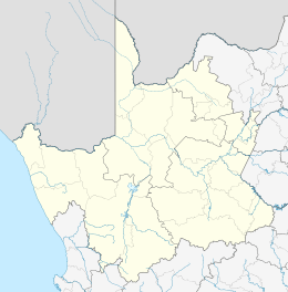
 KIM Location in the Northern Cape | |||||||||||||||
| Runways | |||||||||||||||
| |||||||||||||||

Six Romanian aviators and cpt. Fisher (airport chief, middle) at Kimberley Airport, 1935-04-24
Kimberley Airport (IATA: KIM, ICAO: FAKM) is an airport serving Kimberley,[2] the capital city of the province of Northern Cape in South Africa.
Facilities
The airport is at an elevation of 3,950 feet (1,204 m) above mean sea level. It has two asphalt paved runways: 02/20 measuring 3,000 by 46 metres (9,843 ft × 151 ft) and 10/28 measuring 2,439 by 46 metres (8,002 ft × 151 ft).[1]
- Non-directional beacon - KM365.0
- VHF omnidirectional range - KYV113.2
- Pilot Controlled Lighting - 5 clicks 118.6
Airlines and destinations
| Airlines | Destinations |
|---|---|
| Airlink | Cape Town, Johannesburg-OR Tambo |
| Fly Blue Crane | Cape Town, Johannesburg-OR Tambo |
| South African Express | Johannesburg-OR Tambo |
Traffic statistics
| Year | Passengers | % Change |
|---|---|---|
| 2006 | 129,037 | |
| 2007 | 147,275 | |
| 2008 | 155,615 | |
| 2009 | 130,506 | |
| 2010 | 132,756 | |
| 2011 | 135,939 | |
| 2012 | 153,125 | |
| 2013 | 152,667 | |
See also
References
- 1 2 "Aerodrome chart for FAKM – KIMBERLEY" (PDF). South African Civil Aviation Authority. 10 May 2007.
- 1 2 Airport information for FAKM from DAFIF (effective October 2006)
- ↑ Airport information for KIM at Great Circle Mapper. Source: DAFIF (effective October 2006).
- ↑ "ACSA Passenger Statistics". Airports Company South Africa. Retrieved 23 October 2013.
External links
- Kimberley Airport Homepage
- More useful information about Kimberley - Photos, planespotting,...
- Aerial Photograph on Google Maps
- Current weather for FAKM at NOAA/NWS
- Accident history for KIM at Aviation Safety Network
This article is issued from Wikipedia - version of the 12/4/2016. The text is available under the Creative Commons Attribution/Share Alike but additional terms may apply for the media files.