Killiniq Island
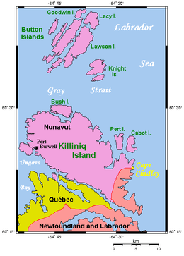 Map of Killiniq Island | |
| Geography | |
|---|---|
| Location | Northern Canada |
| Coordinates | 60°22′N 64°37′W / 60.367°N 64.617°WCoordinates: 60°22′N 64°37′W / 60.367°N 64.617°W |
| Archipelago | Canadian Arctic Archipelago |
| Area | 269 km2 (104 sq mi) |
| Administration | |
|
Canada | |
| Province / Territory |
Newfoundland and Labrador; and Nunavut |
| Demographics | |
| Population | Uninhabited |
Killiniq Island (English: ice floes[1]) is a small, remote island in northeastern Canada. Located at the extreme northern tip of Labrador between Ungava Bay and the Labrador Sea, it is notable in that it contains the only land border between Nunavut territory and the province of Newfoundland and Labrador. Most other islands off the northern coast of Quebec and Labrador belong exclusively to Nunavut. Some cartographic sources do not correctly show the island's geopolitical boundaries, for instance the Commission de toponymie du Québec seems to show it belonging to Quebec (an apparent consequence of the province's longstanding boundary dispute with Labrador).[2]
The northernmost point of Newfoundland and Labrador is Cape Chidley on the island. The largest identifiable land mass is the Torngat Mountains, a part of the Arctic Cordillera that proceed from the north to the south of the island.
A former community, meteorological station, coast guard radio station, trading post, missionary post, fishing station, and Royal Canadian Mounted Police post existed through 1978 when it was evacuated by the government of the Northwest Territories. The settlement, also called Killiniq (alternate spelling: Killinek; also known as: Port Burwell; local variants: Killipaartalik or Kikkertaujak; previously: Bishop Jones' Village) was situated on what is now the Nunavut side of the island, part of the territory's Qikiqtaaluk Region. The locality was known by Europeans as early as 1569, marked on a Mercator map.[3] The island is now uninhabited. An automated remote radio transmitter for Iqaluit Coast Guard Radio remains in operation.
References
- ↑ "killiniq". Asuilaak Living Dictionary. Retrieved 2007-12-22.
- ↑ Reference number 179335 of the Commission de toponymie du Québec (French)
- ↑ Barret, M. (September 1994). Killiniq (Port Burwell), an Environmental Survey (PDF). Kuujjuaq, Quebec: Makivik Corporation. pp. 43–45.