Killin
| Killin | |
| Scottish Gaelic: Cill Fhinn | |
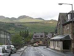 Main Street, Killin, with Meall nan Tarmachan in the background to the north |
|
 Killin |
|
| Population | 666 (2001 Census) |
|---|---|
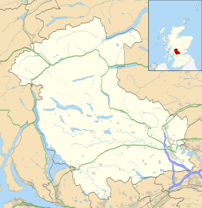
| OS grid reference | NN572328 |
| Civil parish | Killin |
| Council area | Stirling |
| Lieutenancy area | Stirling and Falkirk |
| Country | Scotland |
| Sovereign state | United Kingdom |
| Post town | Killin |
| Postcode district | FK21 |
| Dialling code | 01567 |
| Police | Scottish |
| Fire | Scottish |
| Ambulance | Scottish |
| EU Parliament | Scotland |
| UK Parliament | Stirling |
| Scottish Parliament | Stirling |
Coordinates: 56°27′58″N 4°19′05″W / 56.466°N 4.318°W
Killin (/ˌkɪlˈɪn/; from Cill Fhinn 'the White [or Fair] Church' in Gaelic) is a village situated at the western head of Loch Tay in Stirling (formerly Perthshire), Scotland.
The west end of the village is magnificently sited around the scenic Falls of Dochart, the main street leading down towards the Loch at the confluence of the rivers Dochart and Lochay. The falls are crossed by a narrow, multi-arched stone bridge carrying the main A827 road into Killin.
Killin railway station was on the Killin Railway. The railway station was officially closed on 1 November 1965.
Killin has a small primary school with 56 pupils. For secondary education the children have to travel to Callander, 21 miles to the south. The nearest Gaelic medium primary is in Stirling, 37 miles to the south.
History
The MacNab Clan were once dominant here, and have long been associated with Killin. Their ancient burial ground is on Inchbuie in the River Dochart, just below the falls, and is visible from the bridge.
Kinnell House was the seat of the MacNabs. A well-preserved prehistoric stone circle (possibly 'restored' to improve its appearance) known as Killin Stone Circle can be seen in the grounds of the house. To the north of the village lie the ruins of the Campbells of Breadalbane stronghold of Finlarig Castle, with its associated chapel. The growing power of the Campbells eventually ousted the MacNabs, who lost Kinnell House to their rivals. In 1694 Sir John Campbell of Glenorchy, 1st Earl of Breadalbane established Killin as a Burgh of barony. In 1949 Kinnell House and its estate returned to the ownership of the Chief of Clan Macnab, but in 1978 death duties forced the then Chief, James Charles Macnab of Macnab, to sell most of the estate.[1]
In 1767 the minister of Killin, James Stuart, published the first New Testament in Scottish Gaelic.
By the end of the 18th century there was a local linen industry. Flax was grown locally, spun in small mills and woven into linen by home based weavers. Today, Killin services the local rural community and the growing tourism and leisure industries. In addition to walking on Ben Lawers National Nature Reserve, fishing for trout and salmon there are various watersports available on Loch Tay. Many local vernacular buildings have been preserved or converted, allowing the village to retain much of its historic character.
The 19th century Moirlanich Longhouse in nearby Glen Lochay is a rare surviving example of the cruck frame Scottish longhouse, and is now in the care of the National Trust for Scotland. The former Breadalbane Folklore Centre in the Victorian mill by the falls displays the 'healing stones' of Saint Fillan.
Tomnadashan Mine, an abandoned copper mine overlooking the village, is sometimes identified as the haunt of the Rabbit of Caerbannog of Monty Python and the Holy Grail fame. Nearby Glen Lochay is the mysterious location to which Richard Hannay, played by Robert Donat, heads in the 1935 Alfred Hitchcock film of The 39 Steps.
 Loch Tay, Killin with Ben Lawers on the left taken from a short distance up Sron a Chlachain.
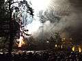 Hogmanay fireworks celebrations on the Bridge of Dochart, Killin.
 Breadalbane Visitor Centre, now Killin Water Mill, looking south east across the Falls of Dochart.
 Killin and Loch Tay from the sides of Sron a Chlachain.
 Killin memorial cross with the McLaren Hall in the background.
 One of many scarecrows in the main street in Killin which are part of the annual Agricultural Festival.
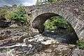 Falls of Dochart with the bridge.
 Finlaring Castle in Killin.
References
- ↑ Know Your Chief at macnabclanuk.org, accessed 25 February 2012
External links
| Wikimedia Commons has media related to Killin. |
- Killin.info community website, guides, photos, media, news.
- YouTube.com video of Killin area featuring Inchbuie.
- Killin - A Village History
- Killin on the Gazeteer for Scotland
- Killin war memorial
- The war memorial discussed on the sculptor's website