Kilflynn
| Kilflynn Cill Flainn | |
|---|---|
| Village | |
 | |
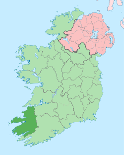
 Kilflynn Location in Ireland | |
| Coordinates: 52°21′02″N 9°37′31″W / 52.3505°N 9.6253°WCoordinates: 52°21′02″N 9°37′31″W / 52.3505°N 9.6253°W | |
| Country | Ireland |
| Province | Munster |
| County | County Kerry |
| Population (2006) | |
| • Total | 126 |
| Time zone | WET (UTC+0) |
| • Summer (DST) | IST (WEST) (UTC-1) |
| Irish Grid Reference | Q895239 |
Kilflynn (Irish: Cill Flainn)[1] is a village in north County Kerry, Ireland. The village is north-east of Tralee just off the N69 road from Tralee to Listowel.
Etymology
The origin of the place name Cill Flainn is unknown. Two suggestions are commonly circulated. ‘Cill’ in Irish can mean 'cell' or 'churchyard' so in context might mean 'church of Flainn.' A popularised tale[2][3] is that it was named after a Roman Catholic hermit monk, Flainn, said to have lived by the River Shannow (which runs through Kilflynn). Crippled and blind, he was visited by the Virgin Mary, who offered to restore his ailing sight. Flainn declined, asking for the miraculous power to be transferred to others via a local well (now Tobar Flainn, well or spring of Flainn). Some refer to this person as ‘St.Flainn,’ but no such person was canonised. There is possible confusion with St.Flannan, originally from Killaloe in County Clare.[4][5] The alternative suggestion is that the name derives from the 'O’Flannan tribe': in August 1931, in the Proceedings of the Royal Irish Academy, a paper referencing a 15th-century manuscript (itself said to be a copy of a 12th-century document) listing rents in Clanmaurice presents both 'O Flannayn' and 'Kyllflanyn' as 'Kilflyn' in the English translation from the original Latin, a significant error which may be the root of the suggestion.[6] The cantred (cf. Welsh cantref or English hundred) or rural deanery of Othorna & Oflannan (Irish Uí Thorna & Uí Flannáin) was an Anglo-Norman sub-division, in this case generally along the historical boundaries of much older kingdoms and regions which were part of West Munster (Irish Iarmuman or Iar Mbumba), in the realm of the Ciarraighe, and which later became County Kerry some time between 1222 and 1229.[7]
Different anglicised spellings appeared over the years. In William Petty's Down Survey of Ireland (1655-1656) the parish appears as 'Kilfloinie Parish'.[8] Charles Smith wrote it as 'Kilflin' in 1756,[9] as did William Wilson 30 years later.[10] In Taylor and Skinner’s road maps of 1777[11] it is spelt 'Kilftyn', likely a transcription error.

Samuel Lewis wrote it 'Kilflyn' in 1840[12] and this spelling is extant in places. Locally, and in most documentation, it is spelt Kilflynn.
Geography
The village lies in the southern part of the Listowel or Kerry plain. The rocks underlying the village area are typically Namurian sandstone and shale[13] which formed between 326 and 313 million years ago during the Carboniferous period and cover 27% of County Kerry. The centre of Kilflynn is actually on the edge of this area.


Immediately to the north and west the bedrock is limestone (later to be sourced from nearby Lixnaw and Abbeydorney for use in lime kilns). These rocks, as part of the Western Irish Namurian Basin (or Clare Basin) were formed in a sub-equatorial tropical environment, due to the deposition of fine particles in a delta, likely from a river flow to the south-west on a continental mass formed from what are now North America, Eastern Europe, Western Europe and Africa.[14] This area is thus part of the Iapetus Suture, that is a region where the ancient Iapetus Ocean closed up. The Atlantic Ocean had yet to form.
The area was subject to glaciation during the ice ages. The glacial meltwater evidence coincides with an area to the south and east of Kilflynn and the N26 road, broadly in line with the edge of the hills facing the north-west. The ice sheet that covered Ireland split about 19,000 years ago, along a corridor that included the area where Kilflynn lies and going down past Banna Strand (the sea level was lower then) towards the Atlantic. The main ice sheet retreated northwards, separated from the Kerry-Cork ice cap to the south which disappeared approximately 1000 years later.[15]
Kilflynn centre is currently 59m above sea-level, but the village elevation is between 45 and 70m. Its latitude and longitude are 52.3505 and -9.6253 respectively (52° 21' 2 N, 9° 37' 31 W). As with most of the West of Ireland, the weather of the area is strongly affected by the North Atlantic drift and the prevailing south-westerly winds. Being 10 km inland and well beyond the hills to the south-west, Kilflynn is somewhat sheltered from extremes of wind speed and precipitation experienced largely in the south and west of County Kerry. The average yearly rainfall is 1278mm with the wettest months between October and January. The average high/low summer and winter temperatures are 19 °C/12 °C and 9 °C/4 °C respectively.[16] For agriculture and horticulture, the last spring air frost is typically in late March or April, that is to say about five to six weeks later than coastal areas (on exposed land). This is still favourable compared to areas further inland.[17] The agricultural land surrounding the village is regarded as good and mostly unspoilt.
Surface spring water was used until the late 1970s for drinking in some surrounding areas. The regional bedrock aquifers for the purposes of drinking water are regarded as locally important and moderately productive, used where there was no water main connection. In the limestone areas to the north, the aquifers are regionally important.[18] The River Shannow, which runs through Kilflynn, emanates from the hills south-west of the N69 from Tooreen to Stacks Mountain townlands and is a tributary of the River Brick, which in turn joins the River Feale, entering the Atlantic south of Ballybunion. Up until the 1980s, there were eels and fish such as brown trout to be found in the river up at least as far as the Waterfall (where the N69 crosses), with birdlife such as various types of finch, dippers and what are locally called 'cranes' (grey herons, which were caught and eaten historically). Since then, the river life has been affected by pollution.
Kerry County Council, which expects a modest increase in population, has made plans for updated local water treatment, improvements for pedestrians and cyclists, and supporting repopulation with associated services, also commenting on Kilflynn as a choice for commuters [into Tralee and Listowel] while impressing the need to retain its peaceful character.[19]
History until 1900
The first known human presence in Ireland after the last ice age has been determined as c.10,500 years B.C.[20]
When the original Celts of Ireland actually arrived is unknown, with suggestions having been made of between 100 and 5000 years B.C. from linguistic and other evidence.[21] The late Neolithic Beaker folk introduced their cultural advances possibly from the Low Countries or from Iberia; this resulted in key changes and Irish becoming a unique Celtic language. Recent evidence shows a huge number of Irish men have the R1b DNA marker with similarly high percentages also found in other modern 'celtic' areas on the European Atlantic coast, including the Basque region.[22] The first known farmers in Ireland or Britain landed in Kerry c.4350 B.C. but the incidence of their DNA markers is now very scarce, the R1b marker replacing it c.2500 B.C.[23] This coincides well with the arrival of a dominant Beaker culture, including the introduction of copper mining and metallurgy in Kerry.
Kilflynn is in the middle of the area settled in the first century by the Ciarraighe (also Ciarraigh or Ciarraidh], the mediaeval tribe (from which the county name Kerry is derived) and claimed descendents of Ciar the son of the mythological queen Medb of Connacht and one of her lovers, king Fergus mac Róich of Ulster.[24][25]
Prior to this the Velabri[26] around Kerry Head and further south the Iverni people (or Iernoi from the earlier Greek) were noted by Ptolemy to be concentrated in the south-west area of Ireland, speaking the most primitive Goidelic language similar to Gaulish (as recorded on Ogham stones, with examples found close by in Knockbrack and Tralee, from the 6th Century).[27] The Érainn, in Irish tradition, may be the name for the same group of people as there are linguistic links.[28]
Kilflynn was a historical parish in the barony of Clanmaurice. This barony developed from the area which had been in the control of native leaders (especially O'Conors)[29] but was taken over by the Norman, Maurice, son of Thomas FitzGerald of Shanid who died in 1213. Thomas FitzGerald himself was son of Maurice FitzGerald, Lord of Llanstephan, who had supported 'Strongbow', Lord Pembroke, in his Cambro-Norman invasion of Ireland in 1169 and who began the Geraldine dynasty in Ireland and their House of Desmond. Later earls of all County Kerry were scions of the FitzMaurice barons.[30][31] Kilflynn was also the name of the local civil parish with its sixteen constituent townlands: Ballyconnell, Cappagh, Castletown, Cloghaneleskirt, Cloonnafinneela, Crotta, Fahavane, Glanballyma, Gortclohy, Kilflynn (village), Knockbrack East, Knockbrack West, Knocknahila, Rea, Stack’s Mountain and Tooreen.

The Stack family, also of Norman heritage, had their seat at Crotto (later known as Crotta) just north of Kilflynn and also owned surrounding townlands.

Kilflynn had been known as Stackstown, and the name remains geographically in Stack's Mountains south-east of Kilflynn. The family landowners, namely James (owner of Garrynagore, Gortclohy and Cloghanaleskirt), John (owner of Aghacoora), Richard (owner of Killaspicktarvin (and more northerly townlands)) and Thomas Stack (owner of Gortaneare, Ballyconnell, Castletown, Crotta, Glanballyma, Knocknahila, Cloonnafinneela, and Cappagh)[32] forfeited their landed possessions because of their support for the Irish Rebellion of 1641 and the subsequent Catholic Confederation. The reconquest of Ireland between 1649 and 1652 by Cromwellian forces after the English Civil War resulted in the Act for the Settlement of Ireland of 1652 which required a survey for the redistribution of land (hence William Petty's survey) often to invading soldiers in lieu of wages. Henry Ponsonby, the younger brother of a colonel in the New Model Army, was the recipient of the Stacks' (and other) confiscated land - much of which was profitable - and this was reconfirmed in 1666 under the Acts of Settlement.[33][34][35] He built Crotta House in 1669. The house was sold in 1842 by Thomas Carrique Ponsonby (later resident in Dublin, so this possibly marked the end of the Ponsonbys in Kerry)[36] and was being leased by about 1850 by Lieutenant Colonel Henry Horatio Kitchener, father to Horatio Herbert Kitchener, the first Earl Kitchener, Earl of Khartoum, Field Marshal of the British Army and Minister for War for Great Britain, who spent most of his youth at Crotta. The mostly derelict remains of the house itself collapsed or were demolished in the 20th century.[37]

From 1840 the Poor Law Union plans (as basic administrative division) of Listowel[38] replaced the Norman Clanmaurice barony and civil parish boundaries (although the latter continued to be used to make comparisons) after the act of 1838.[39]
Kilflynn was on the main road from Tralee to County Limerick. Farming was the principal industry for centuries and services such as forges for smithing, and lime kilns from the late 1600s (to make lime for acidic soils) developed around this. Local forges were still operational in the mid-20th century. The remains of some kilns can still be found dotted about the landscape. There was a population decline, possibly partly associated with the opening of what is now the main Tralee-Listowel road to the south in 1846, and then the North Kerry railway line with stations opening at Abbeydorney and Lixnaw in 1880 (the line ceasing services entirely from 1978).[40][41] However, there was also from the 1840s onwards the significant effect of the peak years of the Great Famine in which between 20% and 30% of the population of Kerry died or emigrated (see map[42]). In 1841, 1851 and 1861 the population of Kilflynn village was 147, 134 and 119 respectively[43] (in 2011 it was 126).[44] The area covers two election districts (Kilflynn and Kilfeighny) so these figures may not be entirely representative.[45]
History from 1900
Kilflynn people joined the Irish Volunteers, were involved in the War of Independence and the Civil War.
The Kilflynn company of the Irish Volunteers was formed in 1913 of about 100 men, drilled by two ex-British soldiers and reservists named Collins and Sheehy.[46] On 13 June 1914 a separate corps formed in Lixnaw,[47] supported on the day by the Kilflynn and other Volunteers. Later in 1914, the reservists were called up to fight in what became World War I and in addition John Redmond encouraged the Irish to join the Allied forces, so the company disbanded as a result and didn't reform until 1917 at Lixnaw. Engagements with the Royal Irish Constabulary (R.I.C) and the "Tans" ("Black and Tans", officially the R.I.C. Reserve Force) became vehement from 1919 after Churchill's call to British war veterans to assist in Ireland. In March 1921 British forces created a cordon starting from Kilflynn to the Atlantic coast in an attempt to trap and round up IRA members: hundreds of men were imprisoned in Ballyheigue Castle, including just one IRA man.
After two previous failures, the IRA succeeded in blowing up the bridge over the Shannow where the road to Kilflynn joins the Abbeydorney-Lixnaw road (R557). Units from Kilflynn and Abbeydorney lay in wait for Crown forces and opened fire. There were injuries on both sides and a British officer was killed attempting to cross the river.[48]
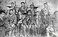
Kilflynn IRA members in the Civil War (‘Irregulars’) included John McElligott, Danny O’Shea, George O’Shea, Stephen Fuller and Tim Twomey. The latter three were blown up by Free State soldiers using a landmine at Ballyseedy Cross, near Tralee, along with six other Irregulars. Fuller, the only survivor of the explosion, was blown clear and escaped the subsequent coup-de-grâce shooting. A fabricated explanation of the event, blaming Irregulars for the mine, was given official approval.[49][50] An investigation by Free State Lieutenant Niall Harrington referred to the report as “totally untrue.” The killings came to represent a defining event in modern Irish history.
Fuller later became a Fianna Fáil T.D. for North Kerry.
Modern-Day Village
In recent decades, especially in the surrounding farmland, migration of youth for better financial prospects has kept a smaller, ageing population present, as is typically reflected elsewhere in rural villages of Ireland.[51] However, a number of new houses have been built and the local school, Scoil Treasa Naofa (St.Teresa's National School)[52] (first sited at Castletown in 1821, just north of the village), has had increased admissions.[53]
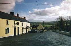
Kilflynn has two pubs, a restaurant, a post office, a florist and a shop. The Catholic Church is St.Mary’s[54] and there is also the 18th century Kilflynn Church of Ireland which is used as St.Columba’s Heritage Centre and Museum; these buildings are Recorded Protected Structures.[55] The latter contains the life story of the major local historical figure of note, Horatio Herbert Kitchener, Earl of Khartoum, the former British Field Marshal and Secretary of State for War, who was born in Ballylongford and spent most of his youth at nearby Crotta House. A few outbuildings are all that remain of the original estate.[56]
Kilflynn and Abbeydorney are the two villages in which church services are held in the modern Roman Catholic parish of Abbeydorney,[57] whose priest is the Very Reverend Denis O’Mahony. The parish is in the deanery of St.Brendan's and is one of 53 in the diocese of Kerry, whose bishop is The Most Reverend Raymond Anthony Browne.
The local parliamentary constituency (since 2016) is Kerry, returning five Teachtaí Dála (T.D.s) to the Dáil Éireann. The current T.D.s are John Brassil (Fianna Fáil), Martin Ferris (Sinn Féin), Brendan Griffin (Fine Gael), Danny Healy-Rae (Independent) and Michael Healy-Rae (Independent).[58]
References
- ↑ Placenames Database of Ireland (see archival records)
- ↑ Go Kerry. "Welcome to Kilflynn". GoKerry.ie. Retrieved 1 June 2015.
- ↑ Parker's Pub. "Parker's Pub". Parker's Pub. Retrieved 1 June 2015.
- ↑ "Dec 18th - St.Flannan (7th Century)". CatholicIreland.et. Retrieved 20 June 2015.
- ↑ "Clare People". Clare County Library. Retrieved 20 June 2015.
- ↑ Pierse, John H. "Pierse: The Pierse Family" (PDF). Pierse. Retrieved 4 August 2015.
- ↑ MacCotter, Paul. "Lordship and Colony in Anglo-Norman Kerry, 1177-1400". Academia. Retrieved 27 June 2015.
- ↑ Petty, William. "The Down Survey of Ireland". Trinity College Dublin: The Down Survey of Ireland. Retrieved 18 July 2015.
- ↑ Smith, Charles (1756). The Antient and Present State of the County of Kerry. Dublin: Charles Smith. p. 71. Retrieved 21 June 2015.
- ↑ Wilson, William (1786). The Post Chaise Companion or Travellers' Directory Through Ireland. Dublin. p. 166.
- ↑ Taylor and Skinner. "Maps of the Roads of Ireland Surveyed 1777". archive.org. open source. Retrieved 1 June 2015.
- ↑ Lewis, Samuel (1840). A Topographical Dictionary of Ireland. London: S.Lewis & Co. p. 446.
- ↑ "Issue No.6 Spring 2007". Geological Survey of Ireland. Geological Survey of Ireland. Retrieved 1 June 2015.
- ↑ "Clare Basin Upper Carboniferous Deepwater Sediments". SEPM Strata. Society for Sedimentary Geology. Retrieved 1 June 2015.
- ↑ Clark, Chris D.; Hughes, Anna L.C.; Greenwood, Sarah L.; Jordan, Colm; Sejrup, Hans Petter (June 2012). "Pattern and timing of retreat of the last British-Irish Ice Sheet". Quaternary Science Reviews. 44: 7, 13, 21–23. doi:10.1016/j.quascirev.2010.07.019.
- ↑ World Weather Online. "Kilflyn Monthly Climate Average, Ireland". World Weather Online. Retrieved 1 June 2015.
- ↑ [( http://www.agresearch.teagasc.ie/johnstown/Soil%20maps/Kerry/book.pdf "County Kerry Agricultural Resource Survey"] Check
|url=value (help) (PDF). 1972. - ↑ "Issue No.6 Spring 2007". Geological Survey of Ireland. Geological Survey of Ireland. Retrieved 1 June 2015.
- ↑ "Tralee Killarney Hub Adopted Settlements Plan: Kilflynn" (PDF). Kerry County Council. Retrieved 1 June 2015.
- ↑ Dowd, Marion; Carden, Ruth F. (21 March 2016). "First evidence of a Late Upper Palaeolithic human presence in Ireland". Quaternary Science Reviews. 140. Retrieved 29 March 2016.
- ↑ Burton, Holly (Spring 1979). "The Arrival of the Celts in Ireland" (PDF). Expedition. 21 (3): 16–22. Retrieved 27 June 2015.
- ↑ Hay, Maciamo. "Haplogroup R1b (Y-DNA)". Eupedia. Retrieved 1 August 2015.
- ↑ "Prehistoric Genocide in Ireland?" (PDF). Ireland's DNA. Retrieved 27 June 2015.
- ↑ "Kerry". LibraryIreland.com. Retrieved 1 June 2015.
- ↑ Ó Cléirigh, Mícheál; Ó Cléirigh, Cú Choigcríche; Ó Maol Chonaire, Fearfeasa; Ó Duibhgeannáin, Peregrine (1636). Annála Ríoghachta Éireann (The Annals of the Kingdom of Ireland) (2nd, 1856 translation ed.). Dublin: Hodges, Smith & Co. p. 177. Retrieved 1 June 2015.
- ↑ Moore, Thomas (1845). The History of Ireland; Commencing with its Earliest Period, to the Expedition Against Scotland in 1545. Philadelphia: Lea & Blanchard. p. 3.
- ↑ Murray, Griffin. "Mediaeval Treasures of County Kerry" (PDF). Comhairle Contae Chiarraí (Kerry County Council). Retrieved 21 July 2015.
- ↑ O'Rahilly, T.F. "On the Origin of the Names Érainn and Ériu". Royal Irish Academy. JSTOR 30007646.
- ↑ Ó Cléirigh, Mícheál; Ó Cléirigh, Cú Choigcríche; Ó Maol Chonaire, Fearfeasa; Ó Duibhgeannáin, Peregrine (1636). Annála Ríoghachta Éireann (The Annals of the Kingdom of Ireland) (2nd, 1856 translation ed.). Dublin: Hodges, Smith & Co. p. 178. Retrieved 1 June 2015.
- ↑ Curtis, Edmund (1923). (A History of Medieval Ireland: from 1086 to 1513,. Oxford: Routledge. pp. 119, 125. ISBN 978-0-4155-2596-1.
- ↑ Ó Cléirigh, Mícheál; Ó Cléirigh, Cú Choigcríche; Ó Maol Chonaire, Fearfeasa; Ó Duibhgeannáin, Peregrine (1636). Annála Ríoghachta Éireann (The Annals of the Kingdom of Ireland) (2nd, 1856 translation ed.). Dublin: Hodges, Smith & Co. Retrieved 1 June 2015.
- ↑ The Down Survey of Ireland. "The Down Survey of Ireland: 1641 landowner search". The Down Survey of Ireland. Retrieved 20 July 2015.
- ↑ Lodge, John (1789). The Peerage of Ireland. Dublin: James Moore. p. 269. Retrieved 21 June 2015.
- ↑ The Spectator eds. "The Ponsonbys". The Spectator Archive. The Spectator. Retrieved 18 July 2015.
- ↑ O'Carroll, Gerald. "How Officers of Cromwell Succeeded to Crotto (Stackstown)". Kerry's History for the E-reader. Retrieved 18 July 2015.
- ↑ Humphrys, Mark. "Thomas Carrique Ponsonby". HumphrysFamilyTree.com. Retrieved 1 June 2015.
- ↑ Humphrys, Mark. "Crotto (or Crotta) Co. Kerry". HumphrysFamilyTree.com. Retrieved 1 June 2015.
- ↑ Higginbotham, Peter. "Listowel, Co.Kerry". The Workhouse. Retrieved 2 August 2015.
- ↑ Poor Law Union. "Poor Relief (Ireland) Act, 1838". Irish Statute Book. Tithe an Oireachtas. Retrieved 1 August 2015.
- ↑ Coleman, Joe. "Limerick as a Railway Centre". Irish Railway Record Society. Retrieved 22 July 2015.
- ↑ Ayres, Bob. "Irish Railways" (PDF). Railscot. Retrieved 22 July 2015.
- ↑ Edwards, ed. R. Dudley; Williams, T.P. (1994). The great famine studies in Irish history 1845 - 52 ([Repr. der Ausg.] 1956, Browne and Nolan. ed.). Dublin: Lilliput Press. pp. 40, 41. ISBN 978-0946640942.
- ↑ Census of Ireland 1881. "Census of Ireland for the Year 1881". DIPPAM: Documenting Ireland: Parliament, People and Migration. EPPI. Retrieved 23 July 2015.
- ↑ An Phriom-Oifig Staidrimh (Central Statistics Office). "Central Statistics Office" (PDF). www.cso.ie. Retrieved 1 June 2015.
- ↑ "Tralee/Killarney Hub: Adopted Settlements Plan" (PDF). Kerry County Council. Retrieved 1 June 2015.
- ↑ Lynch, John. "Statement by Witness: document no W.S. 967" (PDF). Bureau of Military History. An Chartlann Mhíleata. Retrieved 1 June 2015.
- ↑ Lee, J.J. (2009). Kerry's fighting story, 1916-21, told by the men who made it ([New ed.]. ed.). Cork: Mercier Press. p. 79. ISBN 978-1856356411.
- ↑ Lee, J.J. (2009). Kerry's fighting story, 1916-21, told by the men who made it ([New ed.]. ed.). Cork: Mercier Press. pp. 291, 292. ISBN 978-1856356411.
- ↑ Harrington, Niall C. "Niall C. Harrington Papers" (PDF). National Library of Ireland (Leabharlain Náisiúnta na hÉirean)n. Retrieved 1 June 2015.
- ↑ Murphy, Breen Timothy. "The Government's Executions Policy During the Irish Civil War, 1922-1923" (PDF). Maynooth University. National University of Ireland, Maynooth. Retrieved 1 June 2015.
- ↑ "County Kerry Agricultural Resource Survey" (PDF). Teagasc: Agriculture and Food Development Authority. County Kerry Committee of Agriculture. Retrieved 1 June 2015.
- ↑ Scoil Treasa Naofa. "Scoil Treasa Naofa". St.Teresa's National School. Retrieved 20 July 2015.
- ↑ "Tralee/Killarney Hub: Adopted Settlements Plan" (PDF). Kerry County Council (Comhairle Contae Chiarraí). Kerry County Council Planning Department. Retrieved 1 June 2015.
- ↑ Flaherty, John. "St.Mary's Church, Kilflynn". St. Bernard's Parish. Retrieved 23 July 2015.
- ↑ Kerry County Development Plan. "Record of Protected Structures" (PDF). Comhairle Contae Chiarraí (Kerry County Council). Retrieved 21 July 2015.
- ↑ Humphrys, Mark. "Crotto (or Crotta) Co. Kerry". HumphrysFamilyTree.com. Retrieved 1 June 2015.
- ↑ "Abbeydorney". Diocese of Kerry. Diocese of Kerry Ireland. Retrieved 28 March 2016.
- ↑ Office of the Houses of the Oireachtas. "Dáil Éireann Members' Directory". Tithe an Oireachtas (Houses of the Oireachtas). Retrieved 28 March 2016.