Kigali
| Kigali | |
|---|---|
 Kigali, Rwanda | |
 Kigali Map of Rwanda showing the location of Kigali. | |
| Coordinates: 1°56′38″S 30°3′34″E / 1.94389°S 30.05944°ECoordinates: 1°56′38″S 30°3′34″E / 1.94389°S 30.05944°E | |
| Country | Rwanda |
| Province | Kigali City |
| Founded | 1907 |
| Government | |
| • Mayor | Monique MUKARURIZA |
| Area | |
| • Total | 730 km2 (280 sq mi) |
| Elevation | 1,567 m (5,141 ft) |
| Population (2015 census) | |
| • Total | 745,261 |
| • Density | 1,000/km2 (2,600/sq mi) |
| Time zone | CAT (UTC+2) |
| • Summer (DST) | none (UTC+2) |
| Districts 1. Gasabo 2. Kicukiro 3. Nyarugenge |
 |
| Website |
www |
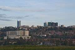
Kigali (Kinyarwanda: [ciɡɑlí]), with a population of more than 1 million (2012), is the capital and largest city of Rwanda. It is situated near the geographic centre of the nation. The city has been the economic, cultural, and transport hub of Rwanda since it became capital at independence in 1962. The main residence and offices of the President of Rwanda are located in the city, as are the government ministries. The city is coterminous with the province of Kigali City, which was enlarged in January 2006, as part of local government reorganisation in the country. Kigali's city limits covers the whole province, it is consolidated. The city's urban area covers about 70% of the municipal boundaries.[1]
History
Kigali was founded in 1907 by Dr. Richard Kandt under German colonial rule, but did not become the capital until Rwandan independence in 1962. The traditional capital was the seat of the mwami (Kings Yuhi V, Mutara III and Kigeli IV) in Nyanza, while the colonial seat of power was in Butare, then known as Astrida. Butare was initially the leading contender to be the capital of the new independent nation, but Kigali was chosen because of its more central location. Since then the city has grown very quickly and is now the major political, economic and cultural centre of Rwanda.
Beginning on April 6, 1994, Kigali was the scene of the Rwandan Genocide – the slaughter of approximately one million Tutsi by Hutu militias (Interahamwe), and some members of the Rwandan army. There was fierce fighting between the army (mostly Hutu) and Tutsi-dominated Rwandan Patriotic Front. Although damaged, the city's structure has recovered.
Geography
The city is built in hilly country, sprawling across about four ridges and the valleys in between. The city centre is located on one of these ridges, with the main government area on another. The tops of the ridges have an average elevation of 1,600 metres or 5,250 feet, while the valleys are around 1,300 metres or 4,270 feet. The bigger houses and office buildings tend to be on the tops of the ridges, while the poorer people live in the valleys. The city is ringed most of the way round by higher hills, with some suburban sprawl rising up these. The highest of these is Mt. Kigali, with an elevation of 1,850 metres or 6,070 feet above sea level.
Climate
Kigali possesses a tropical savanna climate with a pronounced dry season, the Köppen Climate Classification subtype being Aw.[2] Kigali is cooler throughout the year than in most other cities around the Equator due to its elevation, which tempers the heat and results in warm rather than hot days and mild rather than uncomfortably warm nights.
| Climate data for Kigali, Rwanda | |||||||||||||
|---|---|---|---|---|---|---|---|---|---|---|---|---|---|
| Month | Jan | Feb | Mar | Apr | May | Jun | Jul | Aug | Sep | Oct | Nov | Dec | Year |
| Average high °C (°F) | 26.9 (80.4) |
27.4 (81.3) |
26.9 (80.4) |
26.2 (79.2) |
25.9 (78.6) |
26.4 (79.5) |
27.1 (80.8) |
28.0 (82.4) |
28.2 (82.8) |
27.2 (81) |
26.1 (79) |
26.4 (79.5) |
26.89 (80.41) |
| Average low °C (°F) | 15.6 (60.1) |
15.8 (60.4) |
15.7 (60.3) |
16.1 (61) |
16.2 (61.2) |
15.3 (59.5) |
15.0 (59) |
16.0 (60.8) |
16.0 (60.8) |
15.9 (60.6) |
15.5 (59.9) |
15.6 (60.1) |
15.73 (60.31) |
| Average precipitation mm (inches) | 76.9 (3.028) |
91.0 (3.583) |
114.2 (4.496) |
154.2 (6.071) |
88.1 (3.469) |
18.6 (0.732) |
11.4 (0.449) |
31.1 (1.224) |
69.6 (2.74) |
105.7 (4.161) |
112.7 (4.437) |
77.4 (3.047) |
950.9 (37.437) |
| Average precipitation days (≥ 0.1 mm) | 11 | 11 | 15 | 18 | 13 | 2 | 1 | 4 | 10 | 17 | 17 | 14 | 133 |
| Source: World Meteorological Organization[3] | |||||||||||||
Cityscape

Kigali houses several memorials, museums, and centers dedicated to the Rwandan Genocide, including the Kigali Genocide Memorial Centre. Other museums include the Kandt House Museum of Natural History.
Urugwiro is the official residence of the President of Rwanda. It constitutes an entire village within the Kacyiru district of Kigali.
The city has international class hotels, some played a role in history:
- The Mille Collines in the Kiyovu area. This hotel became a refugee centre during the genocide, as famously depicted in the film Hotel Rwanda. It is also the setting for the famous novel Un dimanche à la piscine à Kigali, by Quebecer Gil Courtemanche, and its movie adaptation Un dimanche à Kigali.
- The Kigali Serena Hotel, formerly known as the InterContinental Kigali. Formerly a Belgian-owned hotel known as Hotel Diplomates, the hotel was briefly portrayed in the second half of Hotel Rwanda. It was later bought by the InterContinental Hotels group and remodeled in 2003.
- Kigali Convention Centre, currently under construction.
Economy
Mines for tin ore (cassiterite) have operated nearby, and the city built a smelting plant in the 1980s. Business in Rwanda has been growing in the 21st century, and many new buildings have arisen across the city, including the BCDI Tower, Centenary House and Kigali City Tower. Tourism provides important input into the economy.[4]
National economic background
Rwanda's real GDP growth averaged 8.3 percent between 2002 and 2009. Per capita GDP grew in those years by 252%: from $206 to $520. While 47 percent of Rwandans enjoyed clean water in 2000, the figure grew to 75 by 2010. While 78 percent of the country was considered poor in 1995, that number stood at 57 percent in 2009.[5]
Government
Kigali is a province-level city governed by a city council who appoints an executive committee to run the day-to-day operations of the city. The executive committee consists of a mayor and two deputies. The city is split into three administrative districts: Gasabo, Kicukiro, and Nyarugenge.[6] It contained parts of the former province of Kigali Rural.
Education
Colleges and universities
The administrative head office of the University of Rwanda (UR) is in Kigali.[7] The UR College of Science and Technology campus is in the Southern part of Kigali, at Avenue de l'Armee. (The main academic campus of University of Rwanda is in Butare, the former National University of Rwanda.) Carnegie Mellon University's The College of Engineering has an international campus located in Kigali.[8]
Kigali Independent University has a Kigali campus.[9]
Primary and secondary schools
Lycée de Kigali is the second-largest secondary school in Rwanda, after the Groupe Scolaire in Butare.
Green Hills Academy, in the upscale suburb of Nyarutarama, is a top private school, offering IB at A level, and the Cambridge International Program at O level. It is a PASCH partner school offering German. It has a 50/50 English-French curriculum as well. École Antoine de Saint-Exupéry de Kigali, the French school, is in Kigali. École Belge de Kigali, the Belgian school, is in Kigali. International School of Kigali is also in Kigali. The Earth School -the International Montessori School of Rwanda- is a private preschool and elementary program serving children ages 2–12.
Transportation
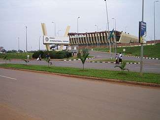
The city has an international airport, Kigali International Airport, with passenger flights to (among others) Amsterdam, Brussels, Nairobi, Entebbe, Johannesburg, and Istanbul. The airport is somewhat limited by its location on the top of a hill, and a brand new one is being considered in the Nyamata area, some 40 kilometres (25 mi) from Kigali.
There are several daily coach services which depart from Kigali to destinations in East Africa. Most leave from the Nyabugogo bus station. These services include:
- Jaguar Executive Coaches, which connects Kigali to Kampala, the Ugandan capital, via Gatuna or via Kayonza and Kagitumba.
- Akamba Bus Services, which runs services to Kampala (8 hours), Nairobi in Kenya (24 hours), Dar es Salaam in Tanzania (36 hours) and Mombasa in Kenya (32 hours)
- Onatracom Express - a Rwandan government service using quite basic buses, running between Kigali and Kampala.
- Yahoo Car Express - A minibus service running between Kigali and Bujumbura in Burundi.
- Kampala Coach Ltd, which runs services to Kampala (8 hours), Nairobi in Kenya (24 hours), Dar es Salaam in Tanzania (36 hours) and Mombasa in Kenya (32 hours).

Kigali is the hub of the Rwanda transport network, with 15 minutes express bus routes to all major towns in the country. The major nationwide companies are Rftc, Stella, Omega, Virunga, Impala and Onatracom, all offers a big bus service, while Volcano Express (to Butare), Virunga Express and Onatracom (to Musanze), Muhabura Express (to Ruhengeri and Rubavu) serve specific destinations and follow a set schedule. There are also taxi minibus services (matatus) leaving from Kigali, which also go through to the major towns, but some of them stop frequently along the route to pick people up or drop them off.
Public transport within Kigali is exclusively by taxi minibus (matatu) routes, connecting the main hubs of Mu (Mujyi) in the city centre, Nyabugogo, Kacyiru, Kimironko and Remera. Similar to the national taxi minibuses, these services wait to fill up before setting off from the terminus, then pick up and drop off frequently en route.
Kigali has many taxis (known as 'special hire' or 'taxi voiture'), which are generally painted white with an orange stripe down the side. There are also motorbike taxis ('taxi moto'), which offer a service similar to a taxi, but for lower prices, typically in the range 300-1000 FRW.
Future
Under a master plan for 2040, Kigali will be decentralized, with business, shopping, and leisure districts, and suburbs. The plan calls for skyscrapers, arching pedestrian walkways and green spaces to be built, alongside amenities such as fountains and a wetlands conservation area. In addition, there will be an effective public transportation network. However, among the most pressing problems is affordable housing for the majority of the city's population, and a number of schemes are under consideration. The city's population of about 1.2 million is expected to triple by that time.[10]
Notes
- ↑ "Kigali at a Glance", Official Website of Kigali City, accessed 15 August 2008
- ↑ Climate Summary for Kigali, Rwanda
- ↑ "World Weather Information Service - Kigali". World Meteorological Organization. Retrieved November 16, 2012.
- ↑ City of Kigali: Kigali Development Strategy, Final Report. Kigali: Kigali Institute of Science Technology & Management. November 2001. See pp. 31–32.
- ↑ Deroy Murdock (February 17, 2011). "The Hills are Alive with the Sounds of Rwanda". National Review.
- ↑ "Administrative Map of Kigali", KigaliCity.gov.rw.
- ↑ "Itegeko rishyiraho Kaminuza y'u Rwanda (UR) rikanagena inshingano, ububasha, imiterere n'imikorere byayo/Law establishing the University of Rwanda (UR) and determining its mission, powers, organisation and functioning/Loi portant création de l'Université du Rwanda (UR) et déterminant ses missions, sa compétence, son organisation et son fonctionnement" (PDF). Official Gazette of the Republic of Rwanda (Igazeti ya Leta ya Repubulika y'u Rwanda/Journal Officiel de la République du Rwanda). Republic of Rwanda Office of the Prime Minister. 23 September 2013. p. 39. Retrieved 8 April 2015.
- ↑ https://www.cmu.edu/rwanda/
- ↑ "Contact Us." Kigali Independent University. Retrieved on 28 February 2013.
- ↑ http://www.theguardian.com/world/2014/apr/04/kigali-plan-rwandan-city-afford-new-homes-offices
External links
![]() Media related to Kigali at Wikimedia Commons
Media related to Kigali at Wikimedia Commons
| Wikivoyage has a travel guide for Kigali. |
| | |
|---|---|