Kies (crater)
|
Lunar Orbiter 4 image (Dark triangle at upper rim is blemish on original photo) | |
| Coordinates | 26°18′S 22°30′W / 26.3°S 22.5°WCoordinates: 26°18′S 22°30′W / 26.3°S 22.5°W |
|---|---|
| Diameter | 44 km |
| Depth | 0.4 km |
| Colongitude | 327° at sunrise |
| Eponym | Johann Kies[1] |
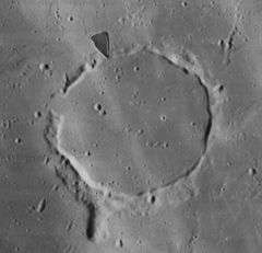
Kies is the remnant of a lunar crater that has been flooded by basaltic lava, leaving only a remnant of the outer rim. It is located in the Mare Nubium almost due south of the crater Bullialdus. Northwest of Kies is König. To the south-southwest lies a lunar dome structure designated Kies Pi (π). It has a small crater at the top, and is most likely volcanic in origin.
The rim of Kies has numerous gaps, and forms a series of ridges in a ring-shaped formation. The most intact rim structures lie in the south and northeast sections of the wall. A low promontory ridge is attached to the southern end of the rim, pointing southwards.
Satellite craters
By convention these features are identified on lunar maps by placing the letter on the side of the crater midpoint that is closest to Kies.
| Kies | Latitude | Longitude | Diameter |
|---|---|---|---|
| A | 28.3° S | 22.7° W | 16 km |
| B | 28.7° S | 21.9° W | 9 km |
| C | 26.0° S | 26.1° W | 5 km |
| D | 24.9° S | 18.5° W | 6 km |
| E | 28.7° S | 22.7° W | 6 km |
References
- Andersson, L. E.; Whitaker, E. A. (1982). NASA Catalogue of Lunar Nomenclature. NASA RP-1097.
- Blue, Jennifer (July 25, 2007). "Gazetteer of Planetary Nomenclature". USGS. Retrieved 2007-08-05.
- Bussey, B.; Spudis, P. (2004). The Clementine Atlas of the Moon. New York: Cambridge University Press. ISBN 978-0-521-81528-4.
- Cocks, Elijah E.; Cocks, Josiah C. (1995). Who's Who on the Moon: A Biographical Dictionary of Lunar Nomenclature. Tudor Publishers. ISBN 978-0-936389-27-1.
- McDowell, Jonathan (July 15, 2007). "Lunar Nomenclature". Jonathan's Space Report. Retrieved 2007-10-24.
- Menzel, D. H.; Minnaert, M.; Levin, B.; Dollfus, A.; Bell, B. (1971). "Report on Lunar Nomenclature by the Working Group of Commission 17 of the IAU". Space Science Reviews. 12 (2): 136–186. Bibcode:1971SSRv...12..136M. doi:10.1007/BF00171763.
- Moore, Patrick (2001). On the Moon. Sterling Publishing Co. ISBN 978-0-304-35469-6.
- Price, Fred W. (1988). The Moon Observer's Handbook. Cambridge University Press. ISBN 978-0-521-33500-3.
- Rükl, Antonín (1990). Atlas of the Moon. Kalmbach Books. ISBN 978-0-913135-17-4.
- Webb, Rev. T. W. (1962). Celestial Objects for Common Telescopes (6th revised ed.). Dover. ISBN 978-0-486-20917-3.
- Whitaker, Ewen A. (1999). Mapping and Naming the Moon. Cambridge University Press. ISBN 978-0-521-62248-6.
- Wlasuk, Peter T. (2000). Observing the Moon. Springer. ISBN 978-1-85233-193-1.