Khentii Province
| Khentii Province Хэнтий аймаг ᠬᠡᠨᠲᠡᠢᠠᠶᠢᠮᠠᠭ | |||
|---|---|---|---|
| Province | |||
 | |||
| |||
 | |||
| Coordinates: 47°19′N 110°39′E / 47.317°N 110.650°ECoordinates: 47°19′N 110°39′E / 47.317°N 110.650°E | |||
| Country | Mongolia | ||
| Established | 1930 | ||
| Capital | Öndörkhaan | ||
| Area | |||
| • Total | 80,325.08 km2 (31,013.69 sq mi) | ||
| Population (2011) | |||
| • Total | 65,811 | ||
| • Density | 0.82/km2 (2.1/sq mi) | ||
| Time zone | UTC+8 | ||
| Area code(s) | +976 (0)156 | ||
| ISO 3166 code | MN-039 | ||
| Vehicle registration | ХЭ_ | ||
| Website |
khentii | ||

Khentii (Mongolian: Хэнтий) is one of the 21 aimags (provinces) of Mongolia, located in the east of the country. Its capital is Öndörkhaan. The aimag is named after the Khentii Mountains. It is best known as the birthplace and likely final resting place of Temüjin (otherwise known as Genghis Khan.)
Geography
The aimag borders with Russia in the north. The neighbouring aimags are Selenge in the northwest, Töv in the west, Govisümber in the southwest, Dornogovi in the south, Sükhbaatar in the southeast, and Dornod in the east. The border to Töv is divided by the city of Baganuur, an administrative exclave of Ulaanbaatar.
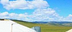
The northwest of the aimag is covered by the eastern part of the Khentii Mountains, towards the southeast the landscape changes into the eastern Mongolian steppe plains. The mountain Burkhan Khaldun in the Khan Khentii Strictly Protected Area is considered sacred, and assumed to be the birthplace of Genghis Khan.
South of Burkhan Khaldun the Kherlen River originates, which crosses the south of the aimag in eastern direction after a detour through Töv. A little further east is the spring of the Onon River. The Balj-Onon National Park is located in the northeast of the aimag.

Population
| Ethnic group | Mongolian name | 1979 | % | 1989 | % | 2000 | % |
|---|---|---|---|---|---|---|---|
| Khalkha | Халх | 42,883 | 81.21 | 57,391 | 77.76 | 61,363 | 86.49 |
| Buriad | Буриад | 6,550 | 12.40 | 7,044 | 9.54 | 6,223 | 8.77 |
| Uriankhai | Урианхай | 595 | 1.13 | 1,004 | 1.36 | 951 | 1.34 |
| Kazakh | Казак (Хасаг) | 1,290 | 2.44 | 3,655 | 4.95 | 629 | 0.89 |
| Dariganga | Дарьганга | 177 | 0.34 | 353 | 0.48 | 361 | 0.51 |
| Dörvöd | Дөрвөд | 154 | 0.29 | 208 | 0.28 | 186 | 0.26 |
| Bayad | Баяд | 56 | 0.11 | 185 | 0.25 | 120 | 0.17 |
| Darkhad | Дархад | 18 | 0.03 | 24 | 0.03 | 32 | 0.05 |
| Torguud | Торгууд | 37 | 0.07 | 19 | 0.03 | 16 | 0.02 |
| Üzemchin | Үзэмчин | 18 | 0.03 | 8 | 0.01 | 3 | 0.00 |
| Other Mongolian citizens | 209 | 0.40 | 161 | 0.22 | 482 | 0.68 | |
| Foreigners | 816 | 1.55 | 3,752 | 5.08 | 580 | 0.82 | |
| Total | 52,803 | 100.00 | 73,804 | 100.00 | 70,946 | 100.00 |
Administrative Subdivision
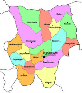
| City | Mongolian | Sum | Population (1994)[2] |
Population (2001)[3] |
Population (2006)[4] |
Population (2007)[5] |
Population (2008)[5] |
Population (2010)[6] |
|---|---|---|---|---|---|---|---|---|
| Berkh | Бэрх | Batnorov | 4,517 | 3,871 | 3,890 | 3,673 | 3,541 | 2,413 |
| Bor-Öndör | Бор-Өндөр | Darkhan | 2,695 | 6,406 | 8,510 | 8,932 | 8,902 | 8,080 |
| Öndörkhaan (capital) | Өндөрхаан | Kherlen | 14,409 | ~12,000 | ~14,800 | ~15,000 | ~15,000 | 17,164 |
| Sum | Mongolian | Population (1994)[2] |
Population (2001)[3] |
Population (2005)[7] |
Population (2008)[5] |
Population (2010)[8] |
Area (km²) |
Density (/km²) |
|---|---|---|---|---|---|---|---|---|
| Batnorov | Батноров | 3,169 | 2,986 | 6739* | 2,833 | 2,693 | 4,968 | 0.54 |
| Batshireet | Батширээт | 2,591 | 2,196 | 2,009 | 2,092 | 2,086 | 7,018 | 0.30 |
| Bayan-Adarga | Баян-Адарга | 2,493 | 2,333 | 2,413 | 2,429 | 2,205 | 3,021 | 0.73 |
| Bayankhutag | Баянхутаг | 2,130 | 2,280 | 2,090 | 1,949 | 1,656 | 6,029 | 0.27 |
| Bayanmönkh | Баянмөнх | 1,646 | 1,790 | 1,693 | 1,532 | 1,347 | 2,540 | 0.53 |
| Bayan-Ovoo | Баян-Овоо | 1,917 | 1,697 | 1,701 | 1,765 | 1,581 | 3,381 | 0.47 |
| Binder | Биндэр | 4,184 | 3,615 | 3,537 | 3,784 | 3,455 | 5,386 | 0.64 |
| Dadal | Дадал | 2,826 | 2,387 | 2,534 | 2,667 | 2,612 | 4,727 | 0.55 |
| Darkhan | Дархан | 1,949 | 1,904 | 9,462** | 1,899 | 1,549 | 4,455 | 0.35 |
| Delgerkhaan | Дэлгэрхаан | 3,029 | 2,902 | 2,339 | 2,353 | 2,040 | 3,986 | 0.51 |
| Galshar | Галшар | 2,575 | 2,906 | 2,468 | 2,074 | 1,807 | 6,676 | 0.27 |
| Jargaltkhaan | Жаргалтхаан | 1,863 | 2,073 | 1,848 | 1,926 | 1,831 | 2,752 | 0.67 |
| Kherlen *** | Хэрлэн | 20,172 | 16,578 | 16,783 | 17,154 | 19,000 | 3,788 | 5.02 |
| Mörön | Мөрөн | 2,444 | 2,264 | 2,026 | 1,934 | 1,326 | 2,196 | 0.60 |
| Norovlin | Норовлин | 2,713 | 2,777 | 2,255 | 2,341 | 2,254 | 5,334 | 0.42 |
| Ömnödelger | Өмнөдэлгэр | 3,895 | 5,739 | 5,208 | 5,148 | 5,156 | 10,877 | 0.47 |
| Tsenkhermandal | Цэнхэрмандал | 2,361 | 1,791 | 1,661 | 1,447 | 2,004 | 3,177 | 0.63 |
- * - including Berkh.
- ** - including Bor-Öndör.
- *** - including The aimag capital Öndörkhaan.
References
- ↑ Khentii Aimag Statistical Office. Statistical Booklet 2008
- 1 2 http://www.reliefweb.int/library/documents/oxfamannex1-4.pdf
- 1 2 The Khentii aimag official site
- ↑ Rural Poverty Reduction Programme:semi-annual report 2007
- 1 2 3 Khentii Aimag Statistical Office. 2008 Annual Report
- ↑ National Census 2010 (bag level divisions)
- ↑ Rural Poverty Reduction Programme official site
- ↑ National Census 2010 (sum level divisions)
 |
Selenge Province | |
| |
| Tov Province | |
Dornod Province | ||
| ||||
| | ||||
| Govisumber Province | Dornogovi Province | Sukhbaatar Province |
| Aimags (provinces) | 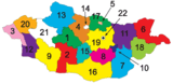 | |
|---|---|---|
| Municipality | ||