Khaset (nome)

Khaset (Mountain bull, also Chasuu) was one of 42 nomes (administrative division) in Ancient Egypt.[1][2][3][4]
| ||
| Khaset in hieroglyphs |
|---|
Geography
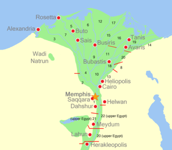
Khaset was one of the 20 nomes in Lower Egypt and had district number 6.
The area of the district is not readable, usually the nomes were about 30-40 km (18-24 miles) in length and their area depending on the depth of the Nile valley and the beginning of the desert.[1] The area was calculated in cha-ta (1 cha-ta equals roughly 2,75 hectare / 2.4 acres) and the distance was calculated in iteru (1 iteru equals roughly 10,5 km / 6.2 miles) in length. [5]
The Niwt (main city) was Khasu/Xois (part of modern Sakha) and among other cities were Per-Wadjet/Buto (modern Tell el-Farain). Per-Wadjet was sometimes also part of the Sap-Meh nome. [2][3][4]
History
Every nome was ruled by a nomarch (provincial governor) who answered directly to the pharaoh.[2][3]
Every niwt had a Het net (temple) dedicated to the chief deity and a Heqa het (nomarch's residence).[1]
The district's main deities were Wadjet and Ra. Other major deities in the area included Isis and Osiris.[2][3][4] Today the area is part of the Gharbia Governorate.
References
- Helck, Wolfgang ; Westendorf, Wolfhart: Lexikon der Ägyptologie. Wiesbaden: Harrassowitz 1977. ISBN 3-447-01876-3
| Wikimedia Commons has media related to Nome of ancient Egypt. |