Kharimkotan
| Native name: <span class="nickname" ">Харимкотан 春牟古丹島 | |
|---|---|
 Wintertime view of Kharimkotan Island | |
 | |
| Geography | |
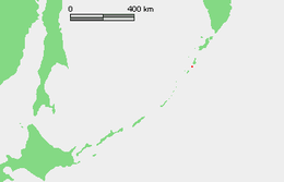
| Location | Sea of Okhotsk |
| Coordinates | 49°07′12″N 154°30′29″E / 49.12°N 154.508°E |
| Archipelago | Kuril Islands |
| Area | 68 km2 (26 sq mi) |
| Highest elevation | 1,145 m (3,757 ft) |
| Highest point | Pik Severgin |
| Administration | |
|
Russia | |
| Demographics | |
| Population | 0 |
| Ethnic groups | Ainu (formerly) |
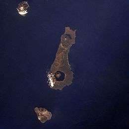
Kharimkotan (Russian: Харимкотан); Japanese 春牟古丹島; Harimukotan-tō, alternatively Harumukotan-tō or 加林古丹島; Karinkotan-tō) is an uninhabited volcanic island located 13 km (8 mi) from Onekotan near the northern end of the Kuril Islands chain in the Sea of Okhotsk in the northwest Pacific Ocean. Its name is derived from the Ainu language, from “village of many Cardiocrinum”.
Geology
Kharimkotan is roughly oval, measuring 8 kilometres (5.0 mi) by 12 kilometres (7.5 mi) with an area of 68 km2 (26 sq mi).[1]
The island consists of a dormant stratovolcano, Pik Severgin -(Russian: влк.Севергина ; Japanese 春牟古丹岳; Harikotan-dake), which rises to 1,157 m (3,796 ft) above sea level. The peak is marked by two horseshoe shaped volcanic craters created by the collapse of the volcanoes upper slopes. Other evidence of the collapse can be seen on the peninsulas to the east and northwest which were formed by the debris. The volcano has erupted occasionally from the 18th century onwards, with the last recorded eruption in 1933 sending volcanic ash as far away as Paramushir. The collapse of the cone resulted in a debris-avalanche which subsequently caused a tsunami, which killed two people on Pamamushir. The path on which the debris took is visible on satellite imagery.
History
Kharimkotan as inhabited by the Ainu at the time of European contact. The remains of a village exist in the northeast of the island, and the inhabitants subsisted by growing the edible bulbs of the Cardiocrinum, as well as fishing and hunting. The island appears on an official map showing the territories of Matsumae Domain, a feudal domain of Edo period Japan dated 1644, and these holdings were officially confirmed by the Tokugawa shogunate in 1715. Subsequently, claimed by the Empire of Russia, sovereignty initially passed to Russia under the terms of the Treaty of Shimoda, but was returned to the Empire of Japan per the Treaty of Saint Petersburg (1875) along with the rest of the Kuril islands. The island was formerly administered as part of Shimushu District of Nemuro Subprefecture of Hokkaidō. After World War II, the island came under the control of the Soviet Union, and is now administered as part of the Sakhalin Oblast of the Russian Federation.
See also
Notes
- ↑ "International Kuril Island Project(IKIP)". University of Washington Fish Collection or the respective authors.
References
Further reading
- Gorshkov, G. S. Volcanism and the Upper Mantle Investigations in the Kurile Island Arc. Monographs in geoscience. New York: Plenum Press, 1970. ISBN 0-306-30407-4
- Krasheninnikov, Stepan Petrovich, and James Greive. The History of Kamtschatka and the Kurilski Islands, with the Countries Adjacent. Chicago: Quadrangle Books, 1963.
- Rees, David. The Soviet Seizure of the Kuriles. New York: Praeger, 1985. ISBN 0-03-002552-4
- Takahashi, Hideki, and Masahiro Ōhara. Biodiversity and Biogeography of the Kuril Islands and Sakhalin. Bulletin of the Hokkaido University Museum, no. 2-. Sapporo, Japan: Hokkaido University Museum, 2004.
External links
| Wikimedia Commons has media related to Kharimkotan. |
- Oceandots at the Wayback Machine (archived December 23, 2010)