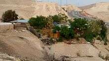
Khan al-Ahmar
.jpg)
| Part of a series on |
| Palestinians |
|---|
 |
| Demographics |
| Politics |
|
| Religion / religious sites |
| Culture |
| List of Palestinians |
Khan al-Ahmar (Arabic: الخان الأحمر, Hebrew: חאן אל-אחמאר, lit. The Red Inn) is a Palestinian village in the Jerusalem Governorate of the West Bank. In 2010, there were 100 Bedouin living there in tents and huts.[1] Khan al-Ahmar is located between the Israeli settlements of Ma'ale Adumim and Kfar Adumim.
History
According to a census conducted in 1931 by the British Mandate authorities, Al-Auja had a population of 27, in 3 houses.[2] Many of the families living in Khan al-Ahmar, from the Bedouin Jahalin tribe, were expelled from the Negev in 1952 by the Israeli army and moved to a location currently within the boundaries of Maale Adumim.[3] The village is one of the only remaining Palestinian areas within the E1 zone, strategically significant because it connects the north and south of the West Bank.[4]
The village was slated to be demolished by Israel in February 2010 due to allegations of illegal building.[5] The Israeli state announced plans in September 2012 to relocate the villagers to the an-Nuway'imah area in the Jordan Valley, north of Jericho. The people of Khan al-Ahmar have opposed this plan.[6] Abu Khamiss, a spokesperson for Khan al-Ahmar residents, said in 2015 that the relocation site would be "like a prison for us".[4]
In July 2009, Italian aid organization Vento Di Terra (Wind of Earth) and other volunteers built a school in the village, using the radical tyre earth method, to address the needs of the community and the difficulty for children to access other schools within the West Bank.[1] A demolition order was served against the school by the Civil Administration one month after it opened, on the basis that it had been built too close to Highway 1, for which expansion plans have already been approved (although representatives of the State have stated demolition would not be carried out until the village relocation is completed).[7]
Since 2009, residents of the nearby Israeli settlements of Kfar Adumim, Alon and Nofei Prat have filed petitions to the Israeli Supreme Court calling for the Israeli military to immediately carry out the standing demolition order against 257 Palestinian structures in the area, including the Khan al-Ahmar school.[8] A lawyer representing the Bedouin community has also petitioned to overturn the demolition order against the school. UNRWA, which operates an education program in Palestine, has also campaigned to defend the Khan al-Ahmar school, arguing that demolishing the school would "effectively deny the children of the community their education and jeopardise their future".[9] The court has so far rejected both sets of petitioners, leaving the village with standing demolition orders.[10]
In 2015, Palestinian NGO Future for Palestine donated solar panels to provide the village with electricity. In July, the Civil Administration confiscated the solar panels, as well as one which had been in the village for several years.[4]
Landmarks
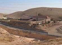
The Good Samaritan Inn (Khan al-Hatruri) is 2.5 kilometres (1.6 mi) east of the village. It is a 16th-century Ottoman-era building believed to have sheltered caravans of traders.[11]
Another inn, traditionally identified as "The Red Inn", hence the Arabic name of the village (Khan al-Ahmar), was built in the 13th century on the site of St Euthymius' monastery , after it was destroyed by the Mamluk sultan Baybars. The monastery had also included an inn, and developed on the remains of The Church of St. Euthymius, built in the 5th century to commemorate Jesus's New Testament story of the Good Samaritan.[12]
References
- 1 2 Jewish Settlements Squeeze Bedouin Enclave National Public Radio, July 23, 2009
- ↑ Mills, 1932, p.45
- ↑ Palestine & Palestinians. Beit Sahour: Alternative Tourism Group. September 2008. p. 162. ISBN 9950-319-01-3.
- 1 2 3 Bainier, Corentin (4 July 2015). "Khan al-Ahmar: the village holding out against Israel". France 24. Israel & the Palestinian Territories. Retrieved 9 March 2016.
- ↑ West Bank village under threat Al Jazeera, 22 February 2010
- ↑ "Bedouins around Ma'ale Adumim". B'Tselem. 18 May 2014. Retrieved 7 March 2016.
In September 2012, the State announced that two alternative sites in the Jericho area – Nu’eimeh North and Armonot Hashmonaim – were being considered for relocation of Bedouins from the area of Khan al-Ahmar near Ma’ale Adumim, adding that the relocation would be carried out through a process that would include representatives of the Jahalin.
- ↑ "Bedouins around Ma'ale Adumim". B'Tselem. 18 May 2014. Retrieved 7 March 2016.
Before the school was opened, the village children had to go schools that were far distant, making trips that were both costly and risky. A month after the school opened, the Civil Administration issued it a demolition order, arguing that it was too close to a main road for which expansion plans have already been approved.
- ↑ Court rejects petition to demolish Beduin school, Jerusalem Post
- ↑ "Campaign to save a West Bank school from demolition". UNRWA. 1 September 2011. Retrieved 9 March 2016.
- ↑ "Bedouins around Ma'ale Adumim". B'Tselem. 18 May 2014. Retrieved 7 March 2016.
- ↑ http://www.parks.org.il/sites/English/ParksAndReserves/GoodSamaritanInn/Pages/default.aspx
- ↑ http://biblewalks.com/Sites/EuthemiusMonastery.html
External links
- http://www.guardian.co.uk/world/2011/jun/12/west-bank-bedouin-school-israeli-bulldozers
- http://www.bbc.co.uk/news/world-middle-east-19985183
Coordinates: 31°48′45.00″N 35°20′16.00″E / 31.8125000°N 35.3377778°E