Kafr Thulth
| Kafr Thulth | |
|---|---|
| Other transcription(s) | |
| • Arabic | كفر ثلث |
| • Also spelled | Kufr Thulth (official) |
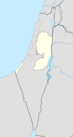 Kafr Thulth Location of Kafr Thulth within the Palestinian territories | |
| Coordinates: 32°9′9″N 35°2′39″E / 32.15250°N 35.04417°ECoordinates: 32°9′9″N 35°2′39″E / 32.15250°N 35.04417°E | |
| Palestine grid | 154/173 |
| Governorate | Qalqilya |
| Government | |
| • Type | Municipality |
| • Head of Municipality | Hussein al-Saifi |
| Area | |
| • Jurisdiction | 24,938 dunams (24.9 km2 or 9.6 sq mi) |
| Population (2007)[1] | |
| • Jurisdiction | 3,921 |
| Name meaning | "The ruin of the village of the third part"[2] |
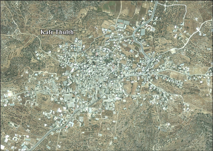
Kafr Thulth (Arabic: كفر ثلث) is a Palestinian town located on high, flat land south of Azzoun, 28 kilometers (17 mi) south of Tulkarm in the Qalqilya Governorate. The average elevation is 270 meters (890 ft) above sea level. According to the Palestinian Central Bureau of Statistics, the town's population was 3,921[1] in the 2007 census.
Name
Kafr in arabic means "village" and Thulth means "three" or "a third".[2] This Arabic name preserves the place name of Baal-shalisha,[3] an ancient village believed to have been located 3.5 miles (5.6 km) to the south at a site known in modern times as Khirbat Sirisya.[4]
Geography

Kafr Thulth is bordered by Azzun to the south, Sanniriya and Biddya villages to the east and Deir Istiya to the west. In 1948, parts of Kharab and Aizab, such as, Salman, al-Moudwer, al-Sheikh Ahmad, al-Ashqar, Ras Tirah, al-Dabha, Kirash Kherba and Ras Atiya — villages or land areas that originally belonged to Kafr Thulth were separated from the town by the Green Line, which forms the border between Israel and the West Bank.
Kafr Thulth's land was extended to the border of the Auja stream and by the 19th century the town's total land area was about 50-60,000 dunams. It had bordered Habla, Jaljuliya, Azzun and Islah, but Kafr Thulth's jurisdiction decreased in 1954; Then, the distance was 924 dunams, while the distance reached up to Kherash Kherba that belong to Kafr Thulth 3,665 dunams.
Archeology
There are several ruins or khirbets in Kafr Thulth:
- Khirbet Kharab: Located in the north direction of the town, with one water well, and has many tombs where can be placed dead people.
- Khirbet Kafr Qari'a: Located one kilometer on the east direction, it has a destroyed mosque, cemetery, wells, cajes, pools, refers to romantic regine' (century), and this place was destroyed after misunderstanding with Kafr Thulth people, and these people transfer to Kufr Qaria; this happened in the 19th century.
- Khirbet al-Baiad: It is on the west side of Kafr Thulth at about 800 meters distance. It has wells and cafes but it has no ruins, or marks, like Kufur Qari'a.
- Khirbet al-Basateen: To the south west of Kafr Thulth, it has wells, and pieces of ruins refers to Romantic period .
- Khirbet al-Zakoor: Located on high land west of Kafr Thulth, lost to Israel in 1948. and transfer the inhabitants of this area, Garaba family was living in this place who the belong to Kufur Thulth, with cafes houses, wells of water, and pools.
- Khirbet Khuraish: Named after Sheikh Mohammad Al-Kheerashi, who worked as Imam of Al-Aqsa mosque, and died in 1033 Higri.
- Khirbet Shuhadi: It is an old place and it is located on the east side of Kafr Thulth within the land of Diristia may be refer to Romantic age, it has water wells and walls.
- Khirbet Abdul Rahim: It has well and walls. Near the old places there is Al-Jamal cafe, it is called Al-Jamal café, because there is a statue of kamel, there was a bridegroom loaded on it, and there are some writings on it, pictures, and may refer to Kanains, many troops have visited Kafr Thulth from Arabs and foreigners. One of these visitors was Al-Bakri Al-Sideeq who visited Palestine who said going to Kafr Thulth is goodness, and we get in to forest during night and we visited Al-Sheilk Rabee, and with us were many of people (religious people) from sofia.
History and occupation
In 1517, the village was incorporated into the Ottoman Empire with the rest of Palestine, and in 1596, Kafr Tult appeared in Ottoman tax registers as being in nahiya (subdistrict) of Jabal Qubal under the liwa' (district) of Nablus. It had a population of 13 households and 1 batchelor, all Muslims. They paid taxes on wheat, barley, summer crops, occasional revenues, goats and/or beehives.[5] In 1835, Kafr Thulth was included in a village list drawn up by Edward Robinson, part of Jurat Merda, south of Nablus.[6]
In 1852, Robinson described Kafr Thulth as "a ruin",[7] and the same did Victor Guérin in 1870.[8] However, later researchers have noted that both only saw Kafr Thulth from a distance, and might have had it mixed up with the ruin Kufr Qara.[9]
In 1882 the Palestine Exploration Fund's Survey of Western Palestine described the village (called Khurbet Kefr Thilth) as "a small village on high ground, with two wells. It was in ruins in 1852, but has now a few inhabitants, the ground round is rough and uncultivated."[3]
In the 1922 census of Palestine conducted by the British Mandate authorities, Kufr Thelth had a population of 643, all Muslims,[10] while in the 1931 census Kafr Thulth, (including Khirbat Khris), had 169 occupied houses and a population of 955, still all Muslim.[11]
Land ownership in 1945
| Ethnic group | Land ownership (dunums)[12] |
|---|---|
| Arab | 24,851 |
| Jewish | 82 |
| Public | 5 |
| Total | 24,938 |
Land usage in 1945
| Land usage type[13] | Arab (dunum) | Jewish (dunum) |
|---|---|---|
| Irrigated and plantation | 1,629 | 0 |
| Area planted with olives | 1,921 | 0 |
| Planted with cereals | 6,329 | 62 |
| Built up[14] | 55 | 0 |
| Cultivable | 7,958 | 62 |
| Non-cultivable | 16,843 | 20 |
| Lands usurped within armistice area | 0 | 1,241 dunums |
Israeli settlements on Kafr Thulth lands
| Arabic | English | Hebrew | Year of construction | Population (2015) |
|---|---|---|---|---|
| أورانيت | Oranit | אורנית | 1983 | 9073 |
Economy
Agriculture
The people of this town work hard to get use of land and plant olive trees the use local workers, and machinal, the land distance increased from 1000 donoms, in 1945 to 18000 donoms, in 2004 before the citizens were working with their neighbors in olive the income of a family reached up to 500 kg of olive oil, in addition of planting vegetables and Blastic houses, in addition of cultivating their lands different kinds of trees, Kafr Thulth is considered the second town in Palestine dealing with the distance of its land, about 2600 donoms, a lot of lands were lost because of occupations, like Turkish, British mandate, most of its people worked in Israeli settlements, the other worked in commercial back to Jordanian Authority on Palestine, they work in cultivation, as farmers, and digging wells of water, and there are eight wells, in salman village, Al-Moudawar and Alsheilk Ahmad.
This town considered as one of towns that plant olive trees and producing a lot of olive oil. So there are three places for squeezing olive fruit in order to get oil out of it. One of these projects is out of service because of having a misunderstanding between the partner, in general the most important problem that the town suffer from is water and this was reflected on planting and cultivating more, and concentrating on well water for irrigation.
Most of people in Kafr Thulth like to breed different kinds of animals and birds like sheep. Goats, doves, chickens, hens, to reinforce the idea of self autonomy, and number of sheep reached up to 10,000 head, besides 40,000 birds in 1998 but these numbers were decreased because of establishing "apartheid wall campaign" which cover a distance of 7000 donoms of land that belong to Kafr Thulth.
Services
General services in Kafr Thulth people are Economical Activity: Kafr Thulth people are very active in all fields "agricultural, educational and commercial" they work very hard, man, woman, worked together to keep live.
Kafr Thulth has many establishments formal and local and these give services to people, like : Local Council : Mayer's worked for a long time in delivering services to people, in Jordanian period and British one, from 1958–1994, this period ended when our Palestinian Authority came in to Palestine and Kafr Thulth became a municipality, because of increasing of people and citizens, and this municipality is run by a chief and twelve members covering all period because of the political reasons from 1966-1974 they establish a clinic, and a public telephone, building more rooms and halls and transfer of school level –from primary to elementary- establishing a school especially for girls in 1972. In period expanded from 1974–1994, many rooms were established, repairing streets and roads, and establishing electrical project by buying electrical motors, fits the needs of the town and establishing Kufur Thuluth charitable society, while period extended from 1995-1997 adding more rooms schools and repairing Al-Ashkar road in cooperation with other establishment, two primary schools were built so far, for girls and boys they spend many efforts to bring in water for Kafr Thulth, but Israeli objected that.
Industry
The industrial sector is very simple and primary one, because of the shortage of the mair resources this sector needs, like electricity isn't enough to over come this problem, while in the last period a wide development was achieved by providing the town with electric – motors – In our town there are four sewing shops, and two metal workshops in addition to mechanic and flat tires workshops.
Education
There are four schools in town, including males and females (girls & boys) and cover different levels of education. The importance of Kafr Thulth secondary school is obvious because other surrounded villages joined in this school, in spite of having schools in place.
References
- 1 2 Census 2007 Locality Population Statistics. Palestinian Central Bureau of Statistics
- 1 2 Palmer, 1881, p. 234
- 1 2 Conder and Kitchener, 1882, SWP II, p. 285
- ↑ Freedman et al., 2000, p. 136.
- ↑ Hütteroth and Abdulfattah, 1977, p. 132
- ↑ Robinson and Smith, 1841, vol 3, 2nd appendix, p.126
- ↑ Robinson and Smith, 1856, p. 136
- ↑ Guérin, 1875, p. 176
- ↑ Grossman and Safrai, 1980, p. 453.
- ↑ Barron, 1923, Table IX, Sub-district of Nablus, p. 26
- ↑ Mills, 1931, p. 65
- ↑ Government of Palestine, Department of Statistics. Village Statistics, April, 1945. Quoted in Hadawi, 1970, p. 75
- ↑ Government of Palestine, Department of Statistics. Village Statistics, April, 1945. Quoted in Hadawi, 1970, p. 126
- ↑ Government of Palestine, Department of Statistics. Village Statistics, April, 1945. Quoted in Hadawi, 1970, p. 176
Bibliography
- Barron, J. B., ed. (1923). Palestine: Report and General Abstracts of the Census of 1922. Government of Palestine.
- Conder, Claude Reignier; Kitchener, H. H. (1882). The Survey of Western Palestine: Memoirs of the Topography, Orography, Hydrography, and Archaeology. 2. London: Committee of the Palestine Exploration Fund.
- Freedman, David Noel; Myers, Allen C.; Beck, Astrid B. (2000). Eerdmans dictionary of the Bible (Illustrated ed.). Wm. B. Eerdmans Publishing. ISBN 9780802824004.
- Grossman, David; Safrai, Ze'ev (1980). "Satellite Settlements in Western Samaria". Geographical Review. American Geographical Society. 70 (4): 446–461. JSTOR 214078.
- Guérin, Victor (1875). Description Géographique Historique et Archéologique de la Palestine (in French). 2: Samarie, pt. 2. Paris: L'Imprimerie Nationale.
- Hadawi, Sami (1970). Village Statistics of 1945: A Classification of Land and Area ownership in Palestine. Palestine Liberation Organization Research Center.
- Hütteroth, Wolf-Dieter; Abdulfattah, Kamal (1977). Historical Geography of Palestine, Transjordan and Southern Syria in the Late 16th Century. Erlanger Geographische Arbeiten, Sonderband 5. Erlangen, Germany: Vorstand der Fränkischen Geographischen Gesellschaft. ISBN 3-920405-41-2.
- Mills, E., ed. (1932). Census of Palestine 1931. Population of Villages, Towns and Administrative Areas. Jerusalem: Government of Palestine.
- Palmer, E. H. (1881). The Survey of Western Palestine: Arabic and English Name Lists Collected During the Survey by Lieutenants Conder and Kitchener, R. E. Transliterated and Explained by E.H. Palmer. Committee of the Palestine Exploration Fund.
- Robinson, Edward; Smith, Eli (1841). Biblical Researches in Palestine, Mount Sinai and Arabia Petraea: A Journal of Travels in the year 1838. 3. Boston: Crocker & Brewster.
- Robinson, Edward; Smith, Eli (1856). Later Biblical Researches in Palestine and adjacent regions: A Journal of Travels in the year 1852. London: John Murray.
External links
- Palestine Remembered Kafr Thulth Page
- Survey of Western Palestine, Map 14: IAA, Wikimedia commons
- Kafr Thulth Town (including ‘Arab al Khawla Locality) (Fact Sheet), ARIJ
- Kafr Thulth Town Profile (including ‘Arab al Khawla Locality), ARIJ
- Kafr Thulth, aerial photo, ARIJ
- Development Priorities and Needs in Kufr Thulth (including ‘Arab al Khawla Locality), ARIJ
| Cities |  | |
|---|---|---|
| Municipalities |
| |
| Villages |
| |