Kfar Tapuach
| Kfar Tapuach כפר תפוח | ||
|---|---|---|
 | ||
| ||
 Kfar Tapuach | ||
| Coordinates: 32°7′5″N 35°15′0″E / 32.11806°N 35.25000°ECoordinates: 32°7′5″N 35°15′0″E / 32.11806°N 35.25000°E | ||
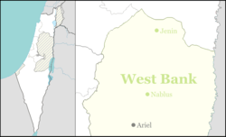
| District | Judea and Samaria Area | |
| Council | Shomrom | |
| Region | West Bank | |
| Affiliation | Hapoel HaMizrachi | |
| Founded | 1978 | |
| Founded by | The Jewish Agency | |
| Population (2015)[1] | 970 | |
| Name meaning | Apple Village | |
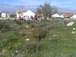
Kfar Tapuach (Hebrew: כְּפַר תַּפּוּחַ, lit., Apple-village), is an Orthodox Jewish Israeli settlement in the West Bank, founded in 1978. It sits astride one of the major traffic junctions in the West Bank. The executive director of the village council is Yisrael Blunder and the chief rabbi is Shimon Rosenzwieg. In 2015 it had a population of 970.
The international community considers Israeli settlements in the West Bank illegal under international law, but the Israeli government disputes this.[2]
Demographics
Although its population consists entirely of Jews, Kfar Tapuach is one of the more diverse Israeli settlements, with its population coming from a range of backgrounds. Founded by a core of Habbani Yemenite Jews from the moshav of Bareket, it has since absorbed Jewish immigrants from Russia and the United States, a large group of Peruvian converts to Judaism from Trujillo, Peru, and others. Between February 2004 and August 2009, over 90 new families moved to Kfar Tapuach.[3]
Public services
- Four synagogues, two of which have three minyanim (prayer gatherings) daily and evening Torah classes; all four are fully functional on Shabbat.
- Two Mikvaot (ritual baths), one for women and one for men.
- A nursery school, and three kindergartens with a playground.[4]
- A qualified and experienced volunteer emergency medical and anti-terrorist team.[5]
Private businesses
Private businesses include a grocery store, mechanic garage, moving company, goat farm, honey bee farm, Klaf (leather parchment) factory, and a perfume factory.[5]
Biblical Tappuah
Kfar Tapuach is located near the archaeological site of Tapuach (Tappuah or Taphua [6]), which appears in the Bible in the Book of Joshua (Joshua 12:17) as one of the first 31 cities conquered by Joshua Bin-Nun and the children of Israel.[7]
Joshua 17:7-8 places Tapuach at the border between the territory of the two sons of Joseph, i. e., the tribes of Manasseh and Ephraim:[8]
- The border [of Manasseh] went along south to the inhabitants of En Tappuah. Manasseh had the [rural] land of Tappuah, but Tappuah on the border of Manasseh belonged to the children of Ephraim.
See also
References
| Wikimedia Commons has media related to Kfar_Tapuach. |
- ↑ "List of localities, in Alphabetical order" (PDF). Israel Central Bureau of Statistics. Retrieved 16 October 2016.
- ↑ "The Geneva Convention". BBC News. 10 December 2009. Retrieved 27 November 2010.
- ↑ "Kfar Tapuach Population Doubles in Two Years - Good News - Israel News". Israel National News. Retrieved 2010-10-21.
- ↑ "The Kfar Tapuach Playground Project". Tapuach.org. Retrieved 2010-10-21.
- 1 2 "Kfar Tapuach - The Shomron Liaison Office". Yeshuv.org. 2010-09-26. Retrieved 2010-10-21.
- ↑ Douai-Rheims 1899 American Edition
- ↑ Bitan, Hanna: 1948-1998: Fifty Years of 'Hityashvut': Atlas of Names of Settlements in Israel, Jerusalem 1999, Carta, p.34, ISBN 965-220-423-4 (Hebrew)
- ↑ Carta's Official Guide to Israel and Complete Gazetteer to all Sites in the Holy Land (3rd edition 1993) Jerusalem, Carta, p.266, ISBN 965-220-186-3 (English)
External links
- Tapuach Playground Project
- NYTimes Israel and U.S. Can’t Close Split on Settlements
- Olive wars, 2014, BBC