Keweenaw Fault
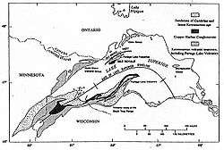
The Keweenaw Fault is a reverse fault that bisects the Keweenaw Peninsula of the Upper Peninsula of Michigan.[1] The fault is the boundary between the Midcontinent Rift System and adjacent Precambrian terrain. The peninsula, itself, is the southeastern side of a large syncline beneath Lake Superior. The northwestern side forms Isle Royale.[2]
The fault is more than 100 miles (160 kilometers) long and traces a northwesterly path.[3] The fault is most likely younger than the Jacobsville Formation and the Devonian Period.[4]
An seismic event in 1906 claimed to be an earthquake has been attributed to a rock burst, as the area has been significantly mined.[5]
The Natural Wall
One significant feature along the Keweenaw Fault is known as the Natural Wall. The Wall is a near-vertical slope of sandstone at a maximum inclination of 85°.[6]
References
- ↑ Brandes, Paul. "Geology of the Keweenaw Peninsula, Michigan". mindat.org. Retrieved March 4, 2012.
- ↑ Huber, N. King (1975). "The Geologic Story of Isle Royal National Park". United States Geological Survey. Retrieved February 2, 2008.
- ↑ Hamblin, W.M. Kenneth (1958). The Cambrian Sandstones of Northern Michigan (PDF) (Report). State of Michigan Department of Conservation. p. 47. Retrieved February 16, 2012.
- ↑ Hamblin, W.M. Kenneth (1958). The Cambrian Sandstones of Northern Michigan (PDF) (Report). State of Michigan Department of Conservation. p. 48. Retrieved February 16, 2012.
- ↑ McLaren, Noël (August 30, 2011). "Could the Keweenaw Fault become active?". Upper Michigan's Source. Retrieved March 4, 2012.
- ↑ Irving, E. D.; Chamberlin, T. C. "Observations on the Junction Between the Eastern Sandstone and the Keweenwaw Series on Kweweenaw Point, Lake Superior" (PDF). State of Michigan. Retrieved July 21, 2011.