Kettle Moraine

Kettle Moraine is a large moraine in the state of Wisconsin, United States. It stretches from Walworth County in the south to Kewaunee County in the north. It has also been referred to as the Kettle Range and, in geological texts, as the Kettle Interlobate Moraine.
The moraine was created when the Green Bay Lobe of the Laurentide Ice Sheet, on the west, collided with the Lake Michigan Lobe of the glacier, on the east, depositing sediment. The western glacier formed Green Bay, Lake Winnebago and the Horicon Marsh. The major part of the Kettle Moraine area is considered interlobate moraine, though other types of moraine features, and other glacial features are common.
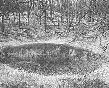
The moraine is dotted with kettles caused by buried glacial ice that calved off the terminus of a receding glacier and got entirely or partly buried in glacial sediment and subsequently melted. This process left depressions ranging from small ponds to large lakes and enclosed valleys. Water-filled kettles range in depth from 3 to 200 ft (0.9 to 60 m). The topography of this area is widely varied between the lakes and kettles and the hills of glacial deposits, which can rise up to 300 ft (90 m) from the lakes. The largest include Holy Hill, Pulford Peak and Lapham Peak. Elkhart Lake, Geneva Lake, and Little Cedar Lake are among the larger kettles now filled by lakes. Kames are also found in the kettle moraine area, and are mounds of compressed glacial till.
Parts of the area have been protected in the Kettle Moraine State Forest.
Recreation
Outdoor recreation opportunities include hiking, biking, cross-country skiing, snowshoeing, horseback riding, and snowmobiling. Fourteen trailheads are dispersed throughout the Northern Unit of the Kettle Moraine State Forest.[1] and 17 in the Southern Unit.[2]
References
- ↑ "Kettle Moraine North trails - Wisconsin DNR". dnr.wi.gov. Retrieved 2015-11-10.
- ↑ "Kettle Moraine South trails - Wisconsin DNR". dnr.wi.gov. Retrieved 2015-11-10.
External links
- Summary of the geological history of Kettle Moraine, northern unit, Wisconsin Department of Natural Resources
- "Northern Kettle Interlobate Moraine", from Geology of Ice Age National Scientific Reserve of Wisconsin by Robert F. Black
- Kettle Moraine Geological Society
Coordinates: 43°35′N 88°11′W / 43.583°N 88.183°W