Keosauqua, Iowa
| Keosauqua, Iowa | |
|---|---|
| City | |
|
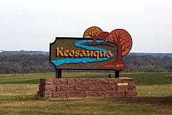
Keosauqua welcome sign | |
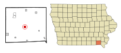 Location of Keosauqua, Iowa | |
| Coordinates: 40°43′56″N 91°57′47″W / 40.73222°N 91.96306°WCoordinates: 40°43′56″N 91°57′47″W / 40.73222°N 91.96306°W | |
| Country |
|
| State |
|
| County | Van Buren |
| Area[1] | |
| • Total | 1.57 sq mi (4.07 km2) |
| • Land | 1.45 sq mi (3.76 km2) |
| • Water | 0.12 sq mi (0.31 km2) |
| Elevation | 584 ft (178 m) |
| Population (2010)[2] | |
| • Total | 1,006 |
| • Estimate (2012[3]) | 993 |
| • Density | 693.8/sq mi (267.9/km2) |
| Time zone | Central (CST) (UTC-6) |
| • Summer (DST) | CDT (UTC-5) |
| ZIP code | 52565 |
| Area code(s) | 319 |
| FIPS code | 19-40935 |
| GNIS feature ID | 0458057 |
Keosauqua (/ˌkiːəˈsɔːkwə/ KEE-ə-SAW-kwə) is a city in Van Buren County, Iowa, United States. The population was 1,006 at the 2010 census. It is the county seat of Van Buren County.[4]
History

Keosauqua was laid out in 1839.[5] The word Keosauqua derives from the Meskwaki and Sauk name for the Des Moines River, "Ke-o-saw-qua", which literally translates as "Bend in the River".[6] The Hotel Manning, a three story relic from the Des Moines River's steamboat days, is Keosauqua's most notable landmark. Also located in Keosauqua are many other notable historic sites. The 1847 Pearson House was a stop on the underground railroad.
The Honey War was fought south of Keosauqua in what is now Lacey-Keosauqua State Park. Lacey-Keosauqua is one of the largest state parks in Iowa and was built by the Civil Conservation Corps during the Great Depression. Keosauqua hosts its annual Fall Festival the second full weekend in October.[7]
Geography
Keosauqua is located at 40°43′56″N 91°57′47″W / 40.73222°N 91.96306°W (40.732089, -91.963027).[8]
According to the United States Census Bureau, the city has a total area of 1.57 square miles (4.07 km2), of which, 1.45 square miles (3.76 km2) is land and 0.12 square miles (0.31 km2) is water.[1]
Demographics
| Historical populations | ||
|---|---|---|
| Year | Pop. | ±% |
| 1850 | 705 | — |
| 1870 | 869 | +23.3% |
| 1880 | 883 | +1.6% |
| 1890 | 831 | −5.9% |
| 1900 | 1,117 | +34.4% |
| 1910 | 1,009 | −9.7% |
| 1920 | 851 | −15.7% |
| 1930 | 855 | +0.5% |
| 1940 | 1,040 | +21.6% |
| 1950 | 1,101 | +5.9% |
| 1960 | 1,023 | −7.1% |
| 1970 | 1,018 | −0.5% |
| 1980 | 1,003 | −1.5% |
| 1990 | 1,020 | +1.7% |
| 2000 | 1,066 | +4.5% |
| 2010 | 1,006 | −5.6% |
| 2014 | 995 | −1.1% |
| 2015 | 947 | −4.8% |
| Source:"American FactFinder". United States Census Bureau. and Iowa Data Center Source: | ||
2010 census
As of the census[2] of 2010, there were 1,006 people, 459 households, and 251 families residing in the city. The population density was 693.8 inhabitants per square mile (267.9/km2). There were 515 housing units at an average density of 355.2 per square mile (137.1/km2). The racial makeup of the city was 97.6% White, 0.4% African American, 0.9% Asian, 0.1% from other races, and 1.0% from two or more races. Hispanic or Latino of any race were 1.1% of the population.
There were 459 households of which 20.7% had children under the age of 18 living with them, 43.1% were married couples living together, 7.4% had a female householder with no husband present, 4.1% had a male householder with no wife present, and 45.3% were non-families. 41.6% of all households were made up of individuals and 23.3% had someone living alone who was 65 years of age or older. The average household size was 2.06 and the average family size was 2.79.
The median age in the city was 50.9 years. 17.5% of residents were under the age of 18; 7.2% were between the ages of 18 and 24; 18.5% were from 25 to 44; 28.3% were from 45 to 64; and 28.8% were 65 years of age or older. The gender makeup of the city was 46.9% male and 53.1% female.
2000 census
As of the census[10] of 2000, there were 1,066 people, 467 households, and 270 families residing in the city. The population density was 728.7 people per square mile (281.9/km²). There were 505 housing units at an average density of 345.2 per square mile (133.5/km²). The racial makeup of the city was 98.59% White, 0.19% African American, 0.28% Asian, and 0.94% from two or more races. Hispanic or Latino of any race were 0.09% of the population.
There were 467 households out of which 24.6% had children under the age of 18 living with them, 44.5% were married couples living together, 10.5% had a female householder with no husband present, and 42.0% were non-families. 38.5% of all households were made up of individuals and 24.8% had someone living alone who was 65 years of age or older. The average household size was 2.10 and the average family size was 2.77.
Age spread: 19.9% under the age of 18, 6.1% from 18 to 24, 19.5% from 25 to 44, 23.1% from 45 to 64, and 31.4% who were 65 years of age or older. The median age was 49 years. For every 100 females there were 77.4 males. For every 100 females age 18 and over, there were 73.9 males.
The median income for a household in the city was $27,833, and the median income for a family was $37,063. Males had a median income of $25,489 versus $19,904 for females. The per capita income for the city was $16,097. About 7.7% of families and 12.1% of the population were below the poverty line, including 14.5% of those under age 18 and 12.7% of those age 65 or over.
Education
Keosauqua is home to the Van Buren Warriors.
Government
Keosauqua is the location of Iowa's oldest courthouse in continuous use; it was built in 1840. The adjacent Hangman's Hollow is the site of the first legal hanging in the state of Iowa.[7]
Notable people
- Josiah H. Bonney (1817-1887), Iowa Secretary of State and territorial legislator.[11]
- Smith W. Brookhart (1869–1944) US Senator from Iowa[12]
- Henry Clay Caldwell (1832–1915) United States federal judge and Union Army officer.[13]
- Sallie Fox (1845–1913), California pioneer who spent her childhood in Keosauqua[14]
- James B. Howell (1816-1880), newspaper editor and U.S. Senator, resided in Keosauqua[15]
- Leonard John Rose (1827-1899), California pioneer and leader of the Rose–Baley Party who lived in Keosauqua from 1848 to 1858[14]
- Phil Stong (1899-1957), an American author, journalist and Hollywood scenarist. He is best known for writing the novel State Fair, upon which three films were based; one starring Will Rogers (1933) and two that were Rodgers and Hammerstein musicals (1945 and 1962).
- Voltaire P. Twombly, (1842-1918), Iowan politician, businessman and Medal of Honor recipient for the American Civil War, is buried in Keosauqua. Twombly briefly served as mayor of Keosauqua, where he had worked as a merchant.[16]
- Edward K. Valentine (1843–1916) US Representative from Nebraska[17]
- George G. Wright (1820–1896) US Senator from Iowa[18]
Gallery
 Historic Hotel Manning, built in the 1890s.
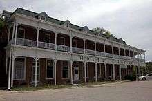 Closeup of Hotel Manning, showing the "steamboat style" design.
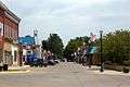 Street scene, downtown Keosauqua.
 Franklin Pearson House, listed on the National Register of Historic Places
See also
- Bentonsport is a 35-acre historical district that was listed on the National Register of Historic Places in 1972.
- Lake Sugema is a constructed artificial 574 acres (2.32 km2) lake.
- The Great Flood of 1851
- USS Keosauqua was a proposed and partially built United States Navy ship during the civil war.
- Des Moines Rapids limited Steamboat traffic through the early 19th century.
- Sullivan Line is the history of the border between Missouri and Iowa.
- Shimek State Forest
Footnotes
- 1 2 "US Gazetteer files 2010". United States Census Bureau. Retrieved 2012-05-11.
- 1 2 "American FactFinder". United States Census Bureau. Retrieved 2012-05-11.
- ↑ "Population Estimates". United States Census Bureau. Retrieved 2013-05-23.
- ↑ "Find a County". National Association of Counties. Retrieved 2011-06-07.
- ↑ The History of Van Buren County, Iowa: Containing a History of the County, Its Cities, Towns, &c. Western Historical Company. 1878. p. 467.
- ↑ Isaac Galland, 1840, Galland's Iowa emigrant: containing a map, and general descriptions of Iowa, p 6-7.
- 1 2 "The Village of Keosauqua Iowa". Affordable-Website-Solutions. Retrieved 2011-01-17.
- ↑ "US Gazetteer files: 2010, 2000, and 1990". United States Census Bureau. 2011-02-12. Retrieved 2011-04-23.
- ↑ "Census of Population and Housing". Census.gov. Retrieved June 4, 2015.
- ↑ "American FactFinder". United States Census Bureau. Retrieved 2008-01-31.
- ↑ University of Iowa Libraries-Papers of Josiah H. Bonney
- ↑ "BROOKHART, Smith Wildman". Biographical Directory of the United States Congress. Retrieved 2011-01-17.
- ↑ "Biographical Directory of Federal Judges Caldwell, Henry Clay". Federal Judicial Center. Retrieved 2011-01-17.
- 1 2 Cheney, J.W. (1915). "The Story of An Emigrant Train". The Annals of Iowa, Vol. 12, No. 2, pp. 82–83.
- ↑ "James B. Howell," National Cyclopaedia of American Biography: Volume 9. New York: James T. White and Company, 1899; pg. 450.
- ↑ "Voltare Paine Twombly". Retrieved July 11, 2014.
- ↑ "VALENTINE, Edward Kimble". Biographical Directory of the United States Congress. Retrieved 2011-01-17.
- ↑ "WRIGHT, George Grover". Biographical Directory of the United States Congress. Retrieved 2011-01-17.
External links
| Wikimedia Commons has media related to Keosauqua, Iowa. |
- City-Data Comprehensive Statistical Data and more about Keosauqua
- Keosauqua Chamber of Commerce
Municipalities and communities of Van Buren County, Iowa, United States | ||
|---|---|---|
| Cities | ||
| CDPs | ||
| Other unincorporated communities | ||
| Ghost town | ||