Kentmere Reservoir
| Kentmere Reservoir | |
|---|---|
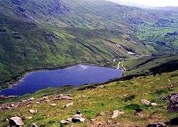 Looking down on the reservoir from Froswick | |
| Location | Kentmere, Cumbria |
| Coordinates | 54°27′54″N 2°51′27″W / 54.46500°N 2.85750°WCoordinates: 54°27′54″N 2°51′27″W / 54.46500°N 2.85750°W |
| Type | reservoir |
| Basin countries | United Kingdom |
Kentmere Reservoir is a water storage facility situated in the Kentmere valley in the county of Cumbria, England. It is located 10.5 km north-northeast of the town of Windermere. The reservoir is fed by the streams which form the headwaters of the River Kent which rises 1.5 km to the north in Hall Cove on the southern slopes of High Street as well as Lingmell Gill which drains the large corrie on the western side of Harter Fell beneath the Nan Bield Pass.
History
The reservoir was built in 1848 after the mill owners on the banks of the River Kent decided they needed a regular and regulated supply of water to drive their water wheels.[1] The main protagonists in the effort to build the reservoir were the James Cropper paper mill at Burneside, Benjamin Turton’s wood mill at Staveley, Wakefield’s gunpowder works at Sedgwick and Gawith Hoggarth’s snuff mill at Helsington.
The mill owners introduced a private bill into parliament in 1845 to get permission to build the reservoir, construction went ahead and was completed three years later.[2] Over the years the James Cropper paper mill became sole owners of the reservoir with exclusive rights for use of the water. However, the firm no longer need the reservoir in their production process even though there is a high use of water in paper making. In 1995 they offered to hand the reservoir over to any new owner for free in return for their paying for repairs totalling £100,000 plus annual maintenance of over £2,000.[3] No buyers came forward and Croppers are still the de facto owners of the reservoir today.[4]
Physical features and location
The reservoir is built in an area of volcanic and low-grade metamorphic (slatey) rocks, which are overlain by a wide tract of Silurian rocks comprising slates and grits. These very old “basement beds” are considered to be effectively impermeable.[5] The reservoir covers an area of 19.5 hectares[6] and holds 1020,000,000 litres of water. It has a 200-metre-long dam wall with a stepped weir type overflow at the western end, and there is a lower outlet for the River Kent in the middle of the dam wall. The reservoir's location is quiet and secluded, surrounded by the fells of Yoke, Froswick, Ill Bell, Thornthwaite Crag, Harter Fell, Mardale Ill Bell and Kentmere Pike. These fells, which make up the Kentmere horseshoe walk around the head and flanks of the Kentmere valley, throw down steep slopes to the shore and give fine views of the reservoir.
References
- ↑ www.cleo.net.uk. Gives construction date and reason for construction.
- ↑ Environment Agency. Gives history.
- ↑ Unwanted reservoir offers Lakeland idyll. Gives details of attempt to give away reservoir in 1995.
- ↑ Croppers confirmed they are still the owners in an email.
- ↑ Environment Agency. Gives geology.
- ↑ www.edenlinks.co.uk. Gives reservoir's area as 48 acres (19.5 hectares).