Kenmore Square
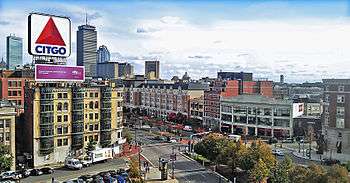
Kenmore Square is a square in Boston, Massachusetts, United States, consisting of the intersection of several main avenues (including Beacon Street and Commonwealth Avenue) as well as several other cross streets, and Kenmore Station, an MBTA subway stop. Kenmore Square is close to or abuts Boston University, Fenway Park, and Lansdowne Street, a center of Boston nightlife. It is also the eastern terminus of U.S. Route 20, the longest road in the United States.
History

The land that is now Kenmore Square was originally the swampy, uninhabited corner of the mainland, which marked where the narrow Charles River fed into the wide, marshy Back Bay. It was part of the colonial settlement of Boston until 1705, when the hamlet of Muddy River incorporated as the independent town of Brookline. The land ended up in Brookline because the Muddy River - several blocks to the east - formed the eastern border of the new city.[1]
Known as Sewell's Point at the time, an 1821 map shows the Great Dam, Brighton Road (Brighton Ave and Commonwealth Ave), and Punch Bowl Road (now Brookline Ave)[2] intersecting at Kenmore[3] which was now connected to the mainland to the west, in addition to the southern connection shown in 1777.[4]
The portion of Beacon Street west of Kenmore Square was laid out in 1850, intersecting with Avenue Street (now the Allston portion of Commonwealth Avenue), Mill Dam Road (now Brookline Avenue), and Western Avenue, a road traversing the Back Bay mill dam in approximately the modern location of Beacon Street. The Boston and Worcester Rail Road and the Charles River Branch Railroad combined here to cross the Back Bay on a separate railroad bridge, making a beeline for the Leather District. The railroad lines still exist on more or less their original alignments, with the city developing around them. Minor adjustments have been made for the construction of South Station, what is now the MBTA Green Line, and the Massachusetts Turnpike.
The city of Brighton was merged with Boston in 1874, and the Boston-Brookline line was redrawn to connect the new Back Bay neighborhood with Allston-Brighton.
Even as late as 1880, Kenmore Square was only sparsely developed.[5] By 1890, the Back Bay landfill project had reached Kenmore Square, for the first time fully connecting it with parts of the city to the east.
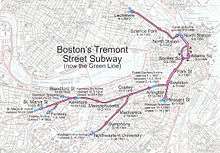
Streetcar tracks were laid on Beacon Street in 1888, passing through Kenmore Square on the surface, from Coolidge Corner to Massachusetts Avenue. These would eventually become the Green Line "C" Branch. Tracks were laid on what by then was called Commonwealth Avenue in 1896, from Union Square in Brighton. These would later serve the Green Line "A" Branch and Green Line "B" Branch. The Boylston Street Subway was extended to Kenmore Square in 1914, where it rose above ground. In 1932, the Kenmore Square portion of the Green Line was put underground, and branch portals opened at Blandford and St. Mary's Streets.
In 1915, the Kenmore Apartments were built on the corner of Kenmore and Commonwealth Avenue. Later, the apartments became the Hotel Kenmore with 400 guest rooms. The Kenmore was owned by Bertram Druker, a prominent Boston developer and was known as the baseball hotel. It housed every one of the 14 teams after World War II. From the 1960s to 1979 it was used by Grahm Junior College as a residence hall, cafeteria, library, and classroom facility. Later, after Grahm Junior College closed and larger hotels like the Sheraton were built, the Hotel Kenmore started to show its age and eventually became apartments again. It is now called Kenmore Abbey.
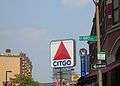
The Citgo sign
A large, double-faced sign featuring the logo of oil company Citgo overlooks Kenmore Square, and has become a famous landmark, partly because of its appearance in the background of televised Red Sox baseball games. The current iteration, 60 feet (18m) square, unveiled in March 2005[6] after a six-month restoration project, features thousands of light-emitting diodes (LEDs) that turn off at 00:00. LEDs were selected for their durability, energy efficiency, intensity, and ease of maintenance; however, the sign was shut down for several months beginning in July 2010 to replace the LEDs with a newer version hopefully more capable of withstanding the winds and temperature extremes seen by the sign. Earlier versions featured neon lighting; the previous sign contained some 5,878 glass tubes with a total length of over 5 miles (8 km).[7] Citgo, which is a subsidiary of Petróleos de Venezuela S.A., refers to its logo as the "trimark". Service on the sign is provided by Federal Heath Sign Company.
The first sign, featuring the Cities Service logo, was built in 1940, and replaced with the trimark in 1965. In 1979, Governor Edward J. King ordered it turned off as a symbol of energy conservation. Four years later, Citgo attempted to disassemble the weatherbeaten sign and was surprised to be met with widespread public affection for the sign and protest at its threatened removal. The Boston Landmarks Commission ordered its disassembly postponed while the issue was debated. While never formally given landmark status, it was refurbished and relit by Citgo in 1983 and has remained in operation ever since.
Although there was, originally, a Cities Service station on the ground floor of the building, there is no associated Citgo gas station—the sign is now a historical landmark, visible over Fenway Park's Green Monster during most televised Boston Red Sox games. It was highlighted in the 1968 short film Go, Go Citgo and a 1983 Life Magazine photograph feature. The association with Fenway and the Red Sox is so strong that local little league fields often are decorated with replicas of the Citgo sign, as is Hadlock Field in Portland, Maine, home of the Red Sox' Double-A minor league affiliate, the Portland Sea Dogs. The sign is caricatured in Neal Stephenson's 1984 book The Big U as "the Big Wheel sign", worshipped by members of a fictional American Megaversity fraternity.
In September 2006, Jerry McDermott, a Boston city councillor, proposed that the sign be removed in response to Venezuelan President Hugo Chávez's insults toward American President George W. Bush. McDermott also suggested draping an American flag or Boston Red Sox banner over the sign until Chávez is out of office.[8]
On October 15, 2008, a small electrical fire inside the sign caused approximately $5,000 worth of damage, partially melting the plastic and leaving visible smoke damage.[9]
In July 2016, the Boston Landmarks Commission voted to grant preliminary landmark status to the famous sign. The preliminary status prevents the sign from being removed from the building until the commission conducts a three-month study and then will vote on permanent landmark status in October 2016.[10]
In October 2016, the Boston Globe reported the building and sign at 660 Beacon Street was purchased by Related Beal. The purchase was part of a nine building deal in Kenmore Square totalling a reported $140 million.[11]
-
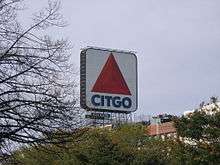
Citgo sign
-
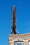
Profile view revealing inner steel skeleton
-
Citgo sign viewed from the end of Yawkey Way
In media
Gary Cherone reminisces about the Kenmore Square music scene in the 1980s on disc one (track six) of Extreme’s 2010 live album Take Us Alive.
The Mighty Mighty Bosstones' reminisce about the closing of The Rathskeller (or "The Rat") on Kenmore Square in "I Want My City Back", a track on A Jacknife to a Swan.
The Queers, on the album Grow Up, mention Kenmore Square in "I Met Her at the Rat" (I lost my brain and I don't know where/somewhere down in Kenmore Square).
See also
References
- ↑ See Image:Middlesex Canal (Massachusetts) map, 1852.jpg or 1844 Brookline map
- ↑ "Boston Fire Historical Society". Bostonfirehistory.org. Retrieved 2013-10-12.
- ↑ "Photo". Bostonhistory.typepad.com. Retrieved 2013-10-12.
- ↑ "Photo". Bostonhistory.typepad.com. 2007-03-16. Retrieved 2013-10-12.
- ↑ "Boston in 1880 : Showing all ground occupied by buildings : Map". Lib.utexas.edu. Retrieved 2013-10-12.
- ↑ Tench, Megan (2005-03-16). "Kenmore Sq. sign gets high-tech makeover". The Boston Globe. Retrieved 2006-09-24.
- ↑ "CITGO.com, Company History, Sign Facts". Citgo.com. Retrieved 2013-10-12.
- ↑ "Boston Official Wants Citgo Sign Removed". Turnto10. 2006-08-22. Retrieved 2006-09-24.
- ↑ "Omen? Citgo sign burns in small fire". The Boston Globe. 2008-10-15. Retrieved 2008-10-15.
- ↑ Handy, Delores (2016-07-13). "Citgo Sign Is Granted Preliminary 'Landmark' Status". WBUR-FM. Retrieved 2016-07-14.
- ↑ Logan, Tim (2016-10-21). "Sale finalized for Kenmore buildings, including Citgo sign location". Boston Globe. Retrieved 2016-10-24.
External links
- Kenmore Square Memorial Facebook Page
- bostonsquares.com - Boston Squares Guide Guide to restaurants, bars and shops in Kenmore Square
- Icons Among Us: The CITGO Sign Article with slideshow
Coordinates: 42°20′55″N 71°05′44″W / 42.348712°N 71.095619°W