Kendrick Peak
| Kendrick Peak | |
|---|---|
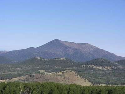 Kendrick Peak as seen from the San Francisco Peaks | |
| Highest point | |
| Elevation | 10,425 ft (3,178 m) NAVD 88[1] |
| Prominence | 2,478 ft (755 m) [2] |
| Coordinates | 35°24′29″N 111°51′04″W / 35.408077619°N 111.850989053°WCoordinates: 35°24′29″N 111°51′04″W / 35.408077619°N 111.850989053°W [1] |
| Geography | |
 Kendrick Peak
| |
| Location | Coconino County, Arizona, U.S. |
| Topo map | USGS Kendrick Peak |
| Geology | |
| Mountain type | dacite, rhyolite |
| Volcanic field | San Francisco volcanic field |
| Climbing | |
| Easiest route | Kendrick Peak Trail[3] |
Kendrick Peak or Kendrick Mountain is one of the highest peaks in the San Francisco volcanic field north of the city of Flagstaff in the U.S. State of Arizona and is located on the Coconino Plateau in Coconino County.
Kendrick Peak rises to a height of 10,425 feet (3,178 m), which makes it the 11th or 12th tallest summit (depending on the source) in Arizona.[4] Kendrick Peak is between 2.7 and 1.4 million years old and consists primarily of dacite and rhyolite flows that were partly buried by andesite according to the USGS.
Kendrick Peak is in the Kendrick Mountain Wilderness which is administered by the Kaibab National Forest. A fire lookout, manned by the United States Forest Service during the week and by volunteers on the weekends, has stood on top of Kendrick Peak since the early 1900s.
There are three maintained trails to the summit of Kendrick Peak - Kendrick Mountain Trail, Pumpkin Trail and Bull Basin Trail.
Along the Kendrick Mountain Trail, near the summit of Kendrick Peak, there is a Colorado Pinyon (Pinus edulis) growing at an altitude of nearly 10,400 feet (3,169.9 meters). This is a rare high-elevation example of this species growing amongst Engelmann spruce (Picea engelmannii) and limber pine (Pinus flexilis).
In the year 2000 the Kendrick Wilderness and Kendrick Peak were involved in a large wildfire, the results of which are still quite evident to hikers or visitors to the peak. In an effort to return the forest to its "pre-fire" state, cattle are sometimes grazed near the Kendrick Mountain Trail trailhead.
Geology
Kendrick Peak is a dome volcano,[5] with some having multiple extrusion vents. Other Arizona examples of dome volcanoes are Mount Elden, Bill Williams Mountain, and Sitgreaves Mountain.[5]
References
- 1 2 "Kendrick". NGS data sheet. U.S. National Geodetic Survey. Retrieved 2016-08-18.
- ↑ "Kendrick Peak, Arizona". Peakbagger.com. Retrieved 2013-01-23.
- ↑ "Kendrick Mountain Trail". Retrieved 2016-08-17.
- ↑ "Arizona 10,000-foot Peaks". Peakbagger.com. Retrieved 2013-01-23.
- 1 2 Luchhitta, Ivo (2001). Hiking Arizona's Geology. Seattle, WA: Mountaineers Books. pp. 128–131. ISBN 978-0898867305.
External links
| Wikimedia Commons has media related to Kendrick Peak. |
- "Kendrick Peak Trail #22." HikeArizona.com
- "Kendrick Wilderness." Wilderness.net.
- "Kendrick Wilderness." Recreation.gov.
- "Kendrick Wilderness." U.S Forest Service.
- "Kendrick Peak". Geographic Names Information System. United States Geological Survey.