Kehewin 123

Kehewin Cree Nation #123 is a Cree Indian reserve in Alberta.[1] Located 20 km south of Bonnyville AB, off Hwy 41 in the northern part of the Moose-hills area (moosachee) and is situated between the Kehewin Lake and Muriel Lake, formerly known as (Goose Lake)with the salt lakes to the north. Approximately 8,212.2 Hectares. Religion in Kehewin is characterised by the predominance of Christianity, Catholic Church, and Native Culture and an increasing diversity of religious practices, beliefs and denominations.
Treaty was signed in February 4, 1884 at Fort Pitt, Saskatchewan and belongs to the Treaty 6 territory area.
Kehewin was first established in the year 1876 when the treaties were first signed. The first Indian agent was Mr. G.G. Mann who was stationed in Onion Lake, Saskatchewan, serving six reserves.
The first Chief "(in Cree) Okimaw" of Kehewin was Chief Kehewin. He was chief till 1885 when the Royal Commissioner took away his chieftainship and his medal. So the Long Lakers were minus a chief for many years. The next chief was Chief J.B. John who was selected by the people of the Kehewin Reserve. He was the grandson of the old Okimaw Kehewin. He was selected in the year 1911. He resigned as chief after ten years due to his illness.
In Cree Language "Kehew" means "Eagle", so therefore the reserve is called "Land of the Eagles", and in Cree language is "Kehewin".
Chief Kehewin selects a land for his people.
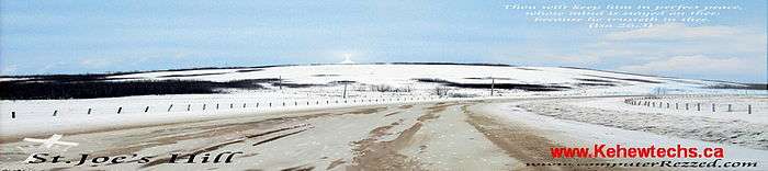
"Chief Kehewin had begun to look for a place to live a more settled existence - a place where there was both an abundance and diversity of resources. They headed north to an area known /ke'poh kepa / (densely enclosed with trees) and now known as Elk Point, this was close to a ford on the North Saskatchewan and not far from where the 'dog rump creek' joins the larger river. Chief Kehewin delegated two hunters from the band to go north from their camp to see if they could find an area that was suitable. He sent the hunters Burland and Gadios. When the two arrived at the top of / (the place you can hear bears crunching choke cherries ) known as St. Joseph's Hill they could see that to the north there was / / (stinking lake) , to the northeast /niska'sagaigun/(goose lake) and to the southwest was /ki'nogimas/ (long lake) - all lakes that could provide fish as well as ducks and eggs in season. Still farther to the north there was an even larger body of water and to the northeast, south and southeast there was the rolling expanse of the
/moos'wachi/ forests - rich in wildlife. It was an excellent place for hunting and
fishing".
Historic Women Chiefs of Kehewin.
The last women Chief, Kehewin had was 1975, Theresa Gadwa, a 51-year-old lady. Her comments that historic time was:
In a telephone interview on the weekend, Chief Gadwa told The Journal being elected chief "doesn't change me. I don't feel any more special or mightier than any other persons on the reserve. I feel I'll be more humble. The people voted for me and I will continue to speak for them." Sadly Theresa Gadwa died on November 27, 2015. She was 95 years old.
Brenda Joly is the new Chief of Kehewin - September 29, 2015.
Events of times...
St.Joseph Hill and The Little Church - Heart of Kehewin.


Visit to 100 year old church at Kehewin Cree Nation
A Merlin Rosser, our Heritage Sites Manager, was recently given the opportunity to visit a 100 year old catholic church at the Kehewin Cree Nation.- See more...
Kehewin Community Education Centre
Education is highly praised and encouraged at Kehewin Schools, ranging from daycare, elementary and high school. For more information on Kehewin School visit the link: Kehewin Community Education Centre.
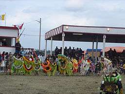
Kehewin Reserve continues to move towards productive lives, promoting Native Culture, language and traditional values which is shown by an Annual Pow-wow every year if time permits with song and dance.

 Promoting good healthy living in Kehewin.
References
- ↑ "Kehewin 123". Statistics Canada. 2001. Retrieved 5 January 2010.
- http://www.elkpointhistory.ca/beginnings/regional-histories/kehewin More...history of Kehewin Cree Nation.
- Visit to 100 year old church at Kehewin Cree Nation
- Visit www.kehewincreenation.ca
- Kehewtechs
- Kehewin Community Education Centre
- KEHEWIN-NATIVE-DANCE-THEATRE-
Coordinates: 54°05′28″N 110°50′46″W / 54.091°N 110.846°W