Kedumba River
| Kedumba | |
| Kedumba Creek (Part), Katoomba Creek (Part)[1] | |
| River | |
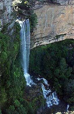 Kedumba River descending into the Jamison Valley over the Katoomba Falls, viewed from Scenic World, Katoomba, 2013. | |
| Country | Australia |
|---|---|
| State | New South Wales |
| Regions | Sydney Basin (IBRA), Blue Mountains, Macarthur |
| Local government areas | Blue Mountains, Wollondilly |
| Part of | Hawkesbury-Nepean catchment |
| Source | Blue Mountains |
| - location | Walford Park, Katoomba, Blue Mountains (New South Wales) |
| - elevation | 556 m (1,824 ft) |
| - coordinates | 33°42′54″S 150°18′23″E / 33.71500°S 150.30639°E |
| Mouth | confluence with the Coxs River to form Lake Burragorang |
| - location | Policeman Point, Warragamba |
| - elevation | 120 m (394 ft) |
| - coordinates | 33°51′21″S 150°20′27″E / 33.85583°S 150.34083°ECoordinates: 33°51′21″S 150°20′27″E / 33.85583°S 150.34083°E |
| Length | 20 km (12 mi) |
| National park | Blue Mountains National Park |
| Valleys | Jamison, Kedumba |
| Waterfalls | Katoomba Cascades, Katoomba Falls |
 | |
| [1][2] | |
The Kedumba River, a perennial river that is part of the Hawkesbury-Nepean catchment, is located in the Blue Mountains and Macarthur regions of New South Wales, Australia.
Course and features
The Kedumba Creek rises on the eastern side of Walford Park, Katoomba and flows generally south over the Katoomba Cascades, Katoomba Falls, and off the Blue Mountains Range, becoming the Kedumba River below the Three Sisters flowing through the Jamison and Kedumba valleys within the Blue Mountains National Park, before reaching its confluence with the Coxs River within Lake Burragorang. The river descends 178 metres (584 ft) over its 20-kilometre (12 mi) course.[2]
See also
- Gandangara people
- List of rivers of Australia
- List of rivers of New South Wales (A-K)
- Rivers of New South Wales
References
- 1 2 "Kedumba River". Geographical Names Register (GNR) of NSW. Geographical Names Board of New South Wales. Retrieved 3 April 2013.
- 1 2 "Kedumba River, NSW". Bonzle Digital Atlas of Australia. Retrieved 3 April 2013.
"Jamison Creek". Geographical Names Register (GNR) of NSW. Geographical Names Board of New South Wales.
River systems and rivers of Sydney Basin, New South Wales, Australia | |||||||
|---|---|---|---|---|---|---|---|
| |||||||
| |||||||
| |||||||
|
This article is issued from Wikipedia - version of the 3/23/2015. The text is available under the Creative Commons Attribution/Share Alike but additional terms may apply for the media files.