Keats Island (British Columbia)
| Keats Island | |
|---|---|
| Coordinates: 49°24′N 123°27′W / 49.400°N 123.450°WCoordinates: 49°24′N 123°27′W / 49.400°N 123.450°W | |
| Country | Canada |
| Province | British Columbia |
| Region | Howe Sound |
| Area | |
| • Total | 6 km2 (2.3 sq mi) |
| • Land | 6 km2 (2.3 sq mi) |
| Elevation | 242 m (795 ft) |
| Exact population is suppressed in Canada Census, because the population is so small. | |
| Time zone | PST (UTC−8) |
| • Summer (DST) | PDT (UTC−7) |
| Area code(s) | 604, 778 |

Keats Island is an inhabited island located in Howe Sound near Vancouver, British Columbia. Around eighty people live on Keats Island year-round.
Physical geography, settlements and climate
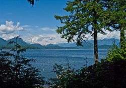
Keats Island is one of the smaller islands in Howe Sound, located offshore from the community of Gibsons on the Sunshine Coast and directly west of Bowen Island.
Other than a few cleared fields, the entire island is covered in forest. There are several beaches scattered around the island, and a prominent rocky outcrop called Salmon Rock at the Southwest tip.
History
Like many of the features in Howe Sound, Keats Island was named by George Henry Richards, who surveyed the British Columbia Coast from 1857 to 1862, first in the HMS Plumper (which is commemorated by the name of Plumper Cover) until 1861, and then in the HMS Hecate. Keats Island is named after Sir Richard Goodwin Keats, a British Admiral. Admiral Keats served under Horatio Nelson, 1st Viscount Nelson and was famous for sailing the HMS Superb through a blockade at Gibraltar in 1801 during the Napoleonic wars. In 1813 Admiral Keats was also a governor of the Island of Newfoundland. Keats Island is the only large island in Howe Sound named for an officer who did not take part in the Battle of Trafalgar, as his ship was undergoing refit at the time. However, he had already established his fame in the Second Battle of Algeciras.
Settlement and services
Residential development on Keats Island is mostly summer cabins, with about 80 full-time residents. Most residents shop and obtain other services in Gibsons, the nearest town of any size.
The communities on Keats Island are clustered around the two government wharves; Keats Landing on the west coast, facing Gibsons and having a view of Shoal Channel separating the island from the mainland, and the larger community of Eastbourne located on the southeast shore. In addition, Plumper Cove extends along the west shore of the island from Freeman's Bluff (just north of the government wharf at Keats landing) to Plumper Cove Marine Provincial Park, and Melody Point on the northwest tip of the island, facing Langdale, British Columbia on the mainland.
Keats Camps is a Baptist summer camp, founded in 1926 on the site of a former orchard, operated on 93 hectares of land on the west part of the island. Keats Landing grew up around the camp, on lots leased from the Baptist Convention of British Columbia.
Barnabas Family Ministries is a camp and retreat centre operated on 64 hectares on the north side of the island. This land was formerly owned by the Corkum family, and was referred to as "Corky's Farm". It is now owned by Rob Bentall.
Access
Visitors to Keats Island can take a BC Ferry vessel from Horseshoe Bay north of Vancouver to Langdale Ferry Terminal on the Sunshine Coast. Keats Island and nearby Gambier Island are served by foot passenger ferry from the ferry terminal at Langdale, and Keats is accessible by water taxi from Gibsons and Horseshoe Bay. For years, Keats was served from Langdale by the ferry "Dogwood Princess" and is now served by the ferry "Stormaway".
There are a few rough roads connecting locations on the island, but there is very little vehicle use. A high proportion of the residential properties are accessible only from the water.
Amenities
Plumper Cove Marine Provincial Park, one of the oldest marine parks in BC, is a popular overnight destination for boats from nearby Gibsons and Vancouver.
External links
| Wikimedia Commons has media related to Keats Island (British Columbia). |
- The Keats Island Website
- Keats Island Conservation Group
- Keats Island Official Community Plan
- BC Ferry schedule for Langdale-Keats Island
- BC Government website for Plumper Cove Marine Provincial Park
- Information about camping on Keats Island
- Keats Camp
- Barnabas Family Ministries
- Mercury Water Taxi (Horseshoe Bay)