Kearsarge North
| Kearsarge North | |
|---|---|
 Kearsarge North as seen from South Baldface | |
| Highest point | |
| Elevation | 3,268 ft (996 m) [1] |
| Prominence | 1,748 ft (533 m) [1] |
| Coordinates | 44°06′20″N 71°05′39″W / 44.105624°N 71.0942377°WCoordinates: 44°06′20″N 71°05′39″W / 44.105624°N 71.0942377°W [2] |
| Geography | |
| Location | Carroll County, New Hampshire, U.S. |
| Topo map | USGS North Conway East |
| Climbing | |
| Easiest route | Hike Kearsarge North Trail from Hurricane Mtn Road. |
Kearsarge North is a mountain located about 4 miles (6 km) northeast of North Conway, Carroll County, New Hampshire. The U.S. Board on Geographic Names accepted the name Pequawket Mountain in 1915 but it was renamed Kearsarge North in 1957.[2] The Pequawket are subdivision of the Abenaki people who formerly lived in the area. It sometimes referred to as Mount Kearsarge, a name officially assigned to a mountain in Merrimack County.
.jpg)
%2C_1836-1918.jpg)
Kearsarge North is located on the eastern fringe of the White Mountains. It is drained by various brooks into the Saco River.
There are two hiking routes up Kearsarge. The first, and most popular, is the 3.1-mile (5.0 km) Mount Kearsarge North Trail, which ascends 2,600 feet (790 m) from the North Conway side of Hurricane Mountain Road, near Intervale. The Weeks Brook Trail, a much less-used 4.7-mile (7.6 km) route, approaches Kearsarge from the east, from a trailhead on Forest Road 317 in Chatham.[3]
An inn was built on the summit, only to be twice destroyed by storms. In 1909, the Appalachian Mountain Club granted the New Hampshire Forestry Commission use of the destroyed hotel for a fire lookout.[4]
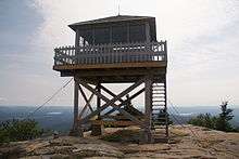
Pequawket Fire Tower
The Pequawket Fire Tower fire lookout tower was built in 1913 and staffed by the state and the US Forest Service until 1960. In 1991, the fire tower was added to the National Historic Lookout Register,[5] and is open to visitors to the summit of Kearsarge North.
See also
References
- 1 2 "Kearsarge North, New Hampshire". Peakbagger.com. Retrieved 2013-01-31.
- 1 2 "Kearsarge North". Geographic Names Information System. United States Geological Survey. Retrieved 2013-01-31.
- ↑ Daniell, Gene; Smith, Steven D. (2003). White Mountain Guide (27th ed.). Appalachian Mountain Club Books. ISBN 9781929173228.
- ↑ Baird, Iris W.; Haartz, Chris (1992). NH Lookout Towers - A Short History. Third Annual Conference of the Forest Fire Lookout Association. Retrieved 2013-01-31.
- ↑ "Pequawket Fire Tower". National Historic Lookout Register. Retrieved 2013-01-31.
External links
- "Mount Kearsarge Gallery". White Mountain Art & Artists.
- "Kearsarge North Mountain Hiking Guide". FranklinSites.com.
- "Mount Kearsarge North (Mount Washington Valley)". SummitPost.org.