Kawachinagano, Osaka
| Kawachinagano 河内長野市 | ||
|---|---|---|
| City | ||
|
Kawachinagano Station, Kōya Kaido, Mikanodai, Kongō-ji, Mikkaichi Station, Kanshin-ji, Takihata 48 Waterfalls, View of Center in Kawachinagano | ||
| ||
 Location of Kawachinagano in Osaka Prefecture | ||
 Kawachinagano Location in Japan | ||
| Coordinates: 34°28′N 135°34′E / 34.467°N 135.567°ECoordinates: 34°28′N 135°34′E / 34.467°N 135.567°E | ||
| Country | Japan | |
| Region | Kansai | |
| Prefecture | Osaka Prefecture | |
| Government | ||
| • Mayor | Keiji Shibata | |
| Area | ||
| • Total | 109.61 km2 (42.32 sq mi) | |
| Population (January 2010) | ||
| • Total | 112,696 | |
| • Density | 1,030/km2 (2,700/sq mi) | |
| Symbols | ||
| • Tree | Camphor laurel | |
| • Flower | Chrysanthemum | |
| Time zone | Japan Standard Time (UTC+9) | |
| City hall address |
1-1-1, Harachō, Kawachinagano-shi, Ōsaka-fu 586-8501 | |
| Website |
www | |
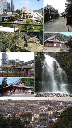

Kawachinagano (河内長野市 Kawachinagano-shi) is a city located in Osaka Prefecture, Japan. The city was founded on April 1, 1954. The city is frequently known as Okukawachi.
As of 2010, the city has an estimated population of 112,696 and a population density of 1,030 persons per km². The total area is 109.61 km².
Having a history extending beyond 1,000 years, the city has the 12th most cultural assets in Japan. Much of the city area is within the forest and mountains, and the riches of nature abound in this district.
Geography
Two major rivers flow through the city; the Ishikawa (the larger) and the Amamigawa (the smaller, a tributary of the Yamatogawa). There are mountains such as Mt.Iwawaki and Mt.Kongō in the south and east.
Transportation
Rail
Kawachinagano Station is the central station of the city.
- Nankai Kōya Line
- Chiyoda Station - Kawachinagano Station - Mikkaichichō Station - Mikanodai Station - Chihayaguchi Station - Amami Station
- Kintetsu Nagano Line
- Shionomiya Station - Kawachinagano Station (terminal)
Bus
- Nankai Bus
- Mockle Community Bus
- Airport Bus Sorae (direct to Kansai Airport)
Road
|
|
Places of interest
Temples and Shrines
- Iwawaki-ji
- Emmei-ji
- Kanshin-ji
- Kawaidera
- Kongō-ji
- Eboshigata Hachiman Jinja
Nature and Parks
- Mount Iwawaki
- Mount Kongō
- Mount Makio
- Takihata Dam
- Teragaike
- Kongō-Ikoma-Kisen Quasi-National Park
- Nagano Park
- Teragaike Park
Amusement parks
- Kansai Cycle Sports Center
- Osaka Prefectural Flowers Garden
Schools
- Osaka Chiyoda Junior College
- Osaka Prefectural Nagano High School
- Osaka Prefectural Naganokita High School
- Seikyo Gakuen High School & Junior High School
- Osaka Gyoko High School
There are 7 junior high schools, 13 elementary schools, 11 kindergartens and 14 day-care centers.
Sister city
People from Kawachinagano
- Shinji Tanimura (singer and songwriter)
- Asuka Hinoi (singer)
- Takuro Fujii (swimmer)
Gallery
 City hall
 kiccs (Library)
 Kawachinagano Station
 Kanshinji
 Kōya Kaidō
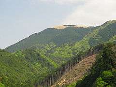 Mt Iwawaki
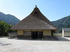 Takihata
.jpg) Kōtaki (Takihata 48 Waterfalls)
Kōtaki (Takihata 48 Waterfalls).jpg) Nantenen (Amami Onsen)
Nantenen (Amami Onsen)
References
- ↑ "City of Carmel, IN: History". City of Carmel, IN. Retrieved 21 October 2011.
External links
| Wikimedia Commons has media related to: |
- Kawachinagano City official website (Japanese)
- Kawachinagano City official website (English)
| Wards of Osaka | ||
|---|---|---|
| Wards of Sakai | ||
| Core cities | ||
| Special cities | ||
| Cities | ||
| Minamikawachi District | ||
| Mishima District | ||
| Senboku District | ||
| Sennan District | ||
| Toyono District | ||