Kavala (regional unit)
| Kavala Περιφερειακή ενότητα Καβάλας | |
|---|---|
| Regional unit | |
|
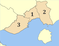
Municipalities of Kavala and Thasos | |
 Kavala within Greece | |
| Coordinates: GR 41°00′N 24°25′E / 41.000°N 24.417°ECoordinates: GR 41°00′N 24°25′E / 41.000°N 24.417°E | |
| Country | Greece |
| Region | East Macedonia and Thrace |
| Capital | Kavala |
| Area | |
| • Total | 1,728 km2 (667 sq mi) |
| Population (2011) | |
| • Total | 124,917 |
| • Density | 72/km2 (190/sq mi) |
| Postal codes | 64x xx, 65x xx |
| Area codes | 2510, 259x0 |
| ISO 3166 code | GR-55 |
| Car plates | ΚΒ |
| Website |
www |
Kavala (Greek: Περιφερειακή ενότητα Καβάλας) is one of the regional units of Greece. It is part of East Macedonia and Thrace. Its capital is the city of Kavala. Kavala regional unit is the easternmost within the geographical region of Macedonia.
Geography
The Pangaio mountains, reaching 1,957 m, are situated in the west. The neighbouring regional units are Serres to the west, Drama to the north and Xanthi to the east. The river Nestos flows along the eastern border. Arable lands are located along the coastline, in the north and in the east.
The regional unit has a predominantly Mediterranean climate.
Administration
The regional unit Kavala is subdivided into 3 municipalities. These are (number as in the map in the infobox):[1]
Prefecture
As a part of the 2011 Kallikratis government reform, the former Kavala Prefecture (Greek: Νομός Καβάλας) was transformed into a regional unit within the East Macedonia and Thrace region. The prefecture also included the island of Thasos, which became a separate regional unit. At the same time, the municipalities were reorganised, according to the table below.[1]
| New municipality | Old municipalities | Seat |
|---|---|---|
| Kavala | Kavala | Kavala |
| Filippoi | ||
| Nestos | Chrysoupoli | Chrysoupoli |
| Keramoti | ||
| Oreino | ||
| Pangaio | Pangaio | Eleftheroupoli |
| Eleftheroupoli | ||
| Eleftheres | ||
| Orfani | ||
| Piereis |
Thasos was and remained one municipality.
Provinces
- Province of Kavala - Kavala
- Province of Pangaio - Eleftheroupoli
- Province of Nestos - Chrysoupoli
- Province of Thasos - Thasos
Note: Provinces no longer hold any legal status in Greece.
Transport
- GR-2/E75, Via Egnatia, old and new, SW, Cen., E
- GR-57, Cen., N
- GR-69, S on the island of Thasos
See also
References
- 1 2 "Kallikratis reform law text" (PDF).
Administrative division of the Eastern Macedonia and Thrace Region | ||
|---|---|---|
| Regional unit of Drama |  | |
| Regional unit of Evros | ||
| Regional unit of Kavala | ||
| Regional unit of Rhodope | ||
| Regional unit of Thasos | ||
| Regional unit of Xanthi | ||
| ||