Kau Yi Chau
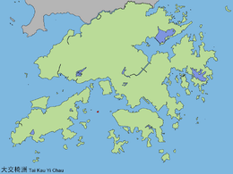 Map showing the location of Kau Yi Chau in Hong Kong | |
| Geography | |
|---|---|
| Location | Between Hong Kong and Lantau islands |
| Highest elevation | 120 m (390 ft) |
| Administration | |
| Islands District | |
| Kau Yi Chau | |||||||||
| Traditional Chinese | 交椅洲 | ||||||||
|---|---|---|---|---|---|---|---|---|---|
| Literal meaning | "chair island" | ||||||||
| |||||||||

Kau Yi Chau (Chinese: 交椅洲, formerly Kau I Island or Kau-i-chau), also known as Tai Kau Yi Chau (大交椅洲), is an uninhabited island located west of Victoria Harbour, between Peng Chau and Green Island in Hong Kong. It is located on the crossroad of sea routes, east to west and north to south. The ferry between Central (Hong Kong Island) and Mui Wo (Lantau Island) sails close to the south of the island. Administratively it is part of Islands District.
Location
The island is isolated from other islands. To its east are Green Island, Little Green Island and Hong Kong Island. To its west are Siu Kau Yi Chau, Peng Chau. To its southwest are Sunshine Island and Hei Ling Chau. To its northwest is Lantau Island.
Geography
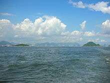
The island is no higher than 120 m (394 ft). A radar station is situated south of its peak. Wave measurement monitors the wave surrounding since 1994.[1] The island south is largely cliff and island is uninhabited. Other than the radar station, the island left Qing tombs, woods and rocks. Chun Hoi Shek (鎮海石) is a major spot on the island. As uninhabited, no regular transport was set up for the island.
Name
Kau Yi (交椅) means chair in the Cantonese language for the island's shape. It is also known as Tai Kau Yi (大交椅) as it is a larger chair compared to Siu Kau Yi (小交椅), a smaller chair, on its west.
History
.jpg)
In 1971, the United States Navy ship USS Regulus (AF-57) riding out typhoon Rose grounded on Kau Yi Chau. After three weeks of attempting to refloat Regulus, it was finally decided that the damage she had incurred was too severe to warrant salvage.
The island was part of the blueprint of Port and Airport Development Strategy. A container port was drawn between the proposed reclamation between Lantau Island and Kau Yi Chau. A proposed cross harbour tunnel connects the reclamation and another proposed reclamation of Green Island. The plan was not realised as a result of prolong disagreement between the governments of British and PRC.
References
External links
| Wikimedia Commons has media related to Kau Yi Chau. |
Coordinates: 22°17′3″N 114°4′36″E / 22.28417°N 114.07667°E