Katakekaumene
| Katekaumene | |
|---|---|
| Kula[1] | |
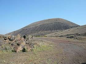 Burnt lands of the Katakekaumene. | |
| Highest point | |
| Elevation | 750 m (2,460 ft) |
| Coordinates | 38°34′38″N 28°31′12″E / 38.57722°N 28.52000°ECoordinates: 38°34′38″N 28°31′12″E / 38.57722°N 28.52000°E |
| Geography | |
 Katekaumene | |

Kula Yanıkyöre rock formations
Katakekaumene or Catacecaumene (Greek: Κατακεκαυμένη) was a name for a district in Lydia (modern western Turkey), and a union of ten cities in the area, during the Hellenistic and Roman periods.
The name means burnt lands and refers to the dormant volcanic belt of Kula,[2] which was first described by Strabo.[3] Strabo (Geography, 12.8.19) reported that some made Katakekaumene the site of the mythological battle between Zeus and the giant Typhon.
Decapolis
Cities of the ancient decapolis included:
- Satala in Lydia
- Maionia in Lydia
- Tabala in Lydia
- Bagis
- Silandos
- Saittae
- Daldis
- Philadelphia in Lydia[4]
- Apollonos-Hieron
- Mesotimolos or Gordos[5]
References
- ↑ Patricia Erfurt-Cooper, Volcanic Tourist Destinations (Springer Science & Business Media, 8 August 2012)| pages 100–101.
- ↑ E. Akdeniz. "SOME EVIDENCE ON THE FIRST KNOWN RESIDENTS OF KATAKEKAUMENE (BURNED LANDS)". Mediterranean Archaeology and Archaeometry. 11 (1): 69–74.
- ↑ The American Journal of Science, Volume 38 (Kline Geology Laboratory, Yale University., 1840 ) p207.
- ↑ Philadelphia in Lydia.
- ↑ W. M. Ramsay, The Historical Geography of Asia Minor (Cambridge University Press, 24 Jun. 2010 ) p132.
This article is issued from Wikipedia - version of the 11/21/2016. The text is available under the Creative Commons Attribution/Share Alike but additional terms may apply for the media files.