Kasol
| Kasol | |
|---|---|
| Hill Station | |
|
Kasol Mountain View | |
 Kasol  Kasol Location in Himachal Pradesh, India | |
| Coordinates: 32°00′35″N 77°18′55″E / 32.00972°N 77.31528°E | |
| Country |
|
| State | Himachal Pradesh |
| District | Kullu |
| Area | |
| • Total | 0.36 km2 (0.14 sq mi) |
| Elevation | 1,580 m (5,180 ft) |
| Languages | |
| • Official | Hindi English |
| Time zone | IST (UTC+5:30) |
| Telephone code | 01907 |
| Vehicle registration | HP- |
| Nearest city | Kullu |
| Literacy | Low% |
| Climate | cool (Köppen) |

Kasol is a village in Himachal Pradesh, northern India.[1][2] It is situated in Parvati Valley, on the banks of the Parvati River, on the way between Bhuntar to Manikaran. It is located 42 km east of Kullu at the height of 1640 meters. It is popular with tourists many of whom also visit nearby village of Tosh.
Parvati Valley
The river Parvati meanders through Kasol producing beautiful landscapes.
Climate
Köppen-Geiger climate classification system classifies its climate as humid subtropical (Cfa).[3]
| Climate data for Kasol, Himachal Pradesh | |||||||||||||
|---|---|---|---|---|---|---|---|---|---|---|---|---|---|
| Month | Jan | Feb | Mar | Apr | May | Jun | Jul | Aug | Sep | Oct | Nov | Dec | Year |
| Average high °C (°F) | 11.6 (52.9) |
14.2 (57.6) |
18.8 (65.8) |
24 (75) |
28.2 (82.8) |
29.3 (84.7) |
25.9 (78.6) |
25 (77) |
24.6 (76.3) |
22.2 (72) |
18.3 (64.9) |
14.2 (57.6) |
21.36 (70.43) |
| Daily mean °C (°F) | 7.4 (45.3) |
9.7 (49.5) |
14 (57) |
18.7 (65.7) |
22.9 (73.2) |
24.3 (75.7) |
22.3 (72.1) |
21.7 (71.1) |
20.6 (69.1) |
17.5 (63.5) |
13.3 (55.9) |
9.7 (49.5) |
16.84 (62.3) |
| Average low °C (°F) | 3.2 (37.8) |
5.2 (41.4) |
9.2 (48.6) |
13.4 (56.1) |
17.6 (63.7) |
19.4 (66.9) |
18.8 (65.8) |
18.4 (65.1) |
16.7 (62.1) |
12.8 (55) |
8.4 (47.1) |
5.3 (41.5) |
12.37 (54.26) |
| Average precipitation mm (inches) | 111 (4.37) |
108 (4.25) |
155 (6.1) |
103 (4.06) |
100 (3.94) |
93 (3.66) |
324 (12.76) |
276 (10.87) |
160 (6.3) |
70 (2.76) |
27 (1.06) |
55 (2.17) |
1,582 (62.3) |
| Source: Climate-Data.org (altitude: 1582m)[3] | |||||||||||||
Gallery
 Kasol Valley Forest Camping
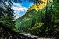 Kasol River Side Village
 Himalayan Region View from Kasol
 Parvati River
.jpg) Himalayan Bulbul spotted
Himalayan Bulbul spotted Parvati River in between Kasol mountains
 The famous Kheerganga Trek route
 Parvati Valley amazing view
References
- ↑ "Say 'High' - Kasol". Retrieved 7 May 2014.
- ↑ NREGA report
- 1 2 "Kasol - Climate graph, Temperature graph, Climate table". Climate-Data.org. Retrieved 2016-03-10.
| Wikimedia Commons has media related to Kasol. |
This article is issued from Wikipedia - version of the 10/1/2016. The text is available under the Creative Commons Attribution/Share Alike but additional terms may apply for the media files.