Kaski District
| Kaski कास्की | |
|---|---|
| District | |
 Location of Kaski | |
| Country | Nepal |
| Region | Western (Pashchimanchal) |
| Zone | Gandaki |
| Headquarters | Pokhara |
| Area | |
| • Total | 2,017 km2 (779 sq mi) |
| Population (2011) | |
| • Total | 492,098 |
| • Density | 240/km2 (630/sq mi) |
| Time zone | NPT (UTC+5:45) |
| Website | www.ddckaski.gov.np/ |
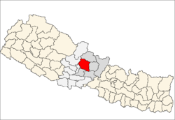
Kaski District (Nepali: कास्की जिल्ला ![]() Listen , a part of Province No. 4, is one of the seventy-five districts of Nepal. The name is disambiguated from Kaskikot, the ancient Kaski Kingdom.
Listen , a part of Province No. 4, is one of the seventy-five districts of Nepal. The name is disambiguated from Kaskikot, the ancient Kaski Kingdom.
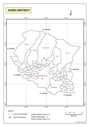
The district, with Pokhara as its district headquarters, covers an area of 2,017 square km and had a population of 492,098 according to 2011 Census. This district lies at the centroid point of the country. The altitude of Kaski district ranges from 450 meters the lowest land to 8091 meters the highest point in the Himalaya range. Kaski District politically has 32 VDCs, 2 municipalities, 13 ilakas and 4 electoral sectors.[1]
The district covers parts of the Annapurna mountain range, and the picturesque scene of the mountains can be observed from most parts of the district. It is one of the best tourist destinations of Nepal. The district is full of rivers such as SetiGandaki, Modi and Madi along with other rivulets. The district headquarters Pokhara lies about 750 m above the sea level and is one of the best tourist destinations in the world. The district is famous for the Himalayan range with about 11 Himalayas with height greater than 7000 m. The famous Peaks include Machhapuchhre (Virgin Peak - 6993m). The Annapurna Range in the northern side is always full of snow. The beautiful scenery of northern mountains, gorge of Seti River, Davis Falls, natural caves, Fewa Lake, Begnas Lake and Rupa Lake are important natural resources of this district with great tourism values.
Etymology
Regarding the name of kaski district, there are many conventions. the main conventions are listed below:
1.The name was derived from Kashyap Rishi who spent his time in Kaskikot making ayurvedic grantha "Kashyap Sagita".
2.The second theory suggests that the name was derived from the people used to live here before many years named "kasayaki".
3. Next theory suggests that the place with natural mineral resources is called "koshkash" and as the district was full of natural mineral resources it was named kaski.
4.Next theory suggests that in the Gurung language the meaning of "kash" is "kachhad-dress of Nepali people" and as here are many people who dress "kachhad" the place was named kaski.
5.Next saying states that the name was originated from the central part of Kaski called Kaskikot.
History
It is believed that human settlement in Kaski was there from Pre-historic period. It was ruled by Malla Kings in the 12th century and after the downfall of Khas Malla kings, the area was believed to be ruled by Gurungs. And with the influence of unification of great Nepal it was ruled by Shah dynasty bIt was then unified into Greater Nepal during the process of unification led by Shree 5 Prithvi Narayan Shah in 1842 B.S.
Politics

All the governance and development of Kaski District are handled mainly by District Development Committee Kaski (DDC-Kaski).
Culture
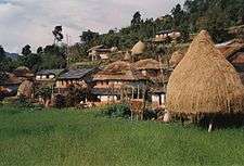
The district is full of people with multi-language, multi-religion and multiple cultures. Different people have different foods, dresses and norms based on their caste and religion. Many places offer Home Stay for internal as well as international tourists along with performance of local dance according to caste and cultures. According to the census of 2068 Kaski district has people of about 84 castes, 44 languages and 11 religions. The dressing style of people here matches with national dress. The main foods of people here are Dal-Bhat Tarkari, Roti, and Dhindo (These are typical Nepalese foods). The district is the common place of different castes such as Gurung, Brahmin, Chhetri, Newar, Thakali, kumal and many more.
Sports
According to the District Sport Committee, Kaski District have one stadium, named Pokhara Rangashala, of about 417 Ropani of area and capacity of 21,000 spectators.
Tourism
1. Phewa Lake: Phewa Lake is one of the most tourism destination of Nepal and the Second big lake of Nepal with the area of 4.43 square km and a perimeter of 18 km The lake is beautiful with the image of Machhapuchhre on it. Boating is fun in Phewa Lake due to the surrounding green forest and the beautiful settlements near it. The Lake also has a beautiful Tal Barahi temple situated at the middle of the lake.
2.Begnas Lake: Located at Lekhnath of Kaski district, is the third big lake of Nepal with the area of 3.73 square km. The lake is famous for its pure water compared with other lakes and the amazing view of Annapurna and Machhapuchhre.
3.Patale Chhango: water falls located at Chorepatan-Pokhara.
4.Gupteshwar Cave: Located at Chorepatan-Pokhara, the cave is famous as religious and tourism destination.
5.Mahendra Cave: Located at Bataulechaur, the cave has length of about 125 m. It has different images of Lord Shiva and Lord Ganesh and others that are natural and are the attracting points of this cave.
6.Seti River: Originated from Machhapuchhre Peak, the river is different from others . The river is astounding because of its beautiful gauges with the depth of about 200 feet.
7.Bindhabasini Temple: The temple is one of the most important religious destination of Nepal. Different beautiful Himalayas can be seen from this temple.
8.Sarangkot: The place is famous for view of sun rise, sun set, awesome view of Pokhara city and paragliding. It is located at about 5500 feet.
9.Machhapuchhre: The peak is famous for its fish tail structure and is 6997m in height, the peak is still not open for mountaineers.
10.Annapurna: The beautiful Annapurna Range is easily seen from almost all places of Kaski district and the range lies in the border between Manang and Myagdi District.
11.Panchase Chhetra: The place is known for its natural, cultural and religious importance. This region lies in the border of Kaski, Parbat and Syangja district. It is important and famous for its following features-
a. It has huge area of about 5500 Hector and with different botanical diversities.
b. It is called 'Panchadham' as it is the combination of 5 different peaks.
c. It is the main origination of 5 important rivers Harpan, Rati, Jare, Aandhi, Seti.
d. Many Himalayas can be seen from this place.
e. It has lake without any origin of water source and the lake is cleaned by Birds around the lake.
f. This is the place with many 'Sunakhari' - you can find about 113 different types of Sungava.
g. The region is famous for its biodiversity as it has different faunas such as 'Lali Gurans', 'Kharshu', 'Chap', 'Chandan' and many more of about 600 types and also the place for different animals such as Tiger, Beer, Deer.
i. Panoramic view of Sun rise and sun set along with the peaceful environment.
Geography and Climate
| Climate Zone[2] | Elevation Range | % of Area |
|---|---|---|
| Upper Tropical | 300 to 1,000 meters 1,000 to 3,300 ft. |
18.6% |
| Subtropical | 1,000 to 2,000 meters 3,300 to 6,600 ft. |
29.4% |
| Temperate | 2,000 to 3,000 meters 6,400 to 9,800 ft. |
16.6% |
| Subalpine | 3,000 to 4,000 meters 9,800 to 13,100 ft. |
12.1% |
| Alpine | 4,000 to 5,000 meters 13,100 to 16,400 ft. |
14.8% |
| Nival | above 5,000 meters | 7.4% |
| Trans-Himalayan | 3,000 to 6,400 meters 9,800 to 21,000 ft. |
0.6% |
Municipalities and Village Development Committees (VDC)
Arba Vijaya, Armala, Begnas, Bhachok, Bhadaure Tamagi, Bhalam, Bharat Pokhari, Chapakot, Dangsing, Deurali, Dhampus, Dhikur Pokhari, Dhital, Ghachok, Ghandruk, Hansapur, Hemja, Kahun, Kalika, Kaskikot, Kristinachnechaur, Lahachok, Lamachaur, Lekhnath Municipality Lumle, Lwangghale, Machhapuchchhre, Majhthana, Mala, Mauja, Mijuredanda, Namarjung, Nirmalpokhari, Parche, Pokhara Sub-metropolitan Municipality, Pumdibhumdi, Puranchaur, Rakhi, Ribhan, Rupakot, Saimarang, Salyan, Sarangkot, Sardikhola, Shisuwa, Siddha, Sildujure, Thumakodada, Thumki
,
See also
References
- ↑ Handbook of District Development Committee, Kaski, 2015. Pokhara, Kaski. 2015. pp. 3–5.
- ↑ The Map of Potential Vegetation of Nepal - a forestry/agroecological/biodiversity classification system (PDF), . Forest & Landscape Development and Environment Series 2-2005 and CFC-TIS Document Series No.110., 2005, ISBN 87-7903-210-9, retrieved Nov 22, 2013 horizontal tab character in
|series=at position 91 (help)
- "Districts of Nepal". Statoids.
- RoyalArk-Nepal history
Coordinates: 28°20′N 84°00′E / 28.333°N 84.000°E
| Wikimedia Commons has media related to Kaski District. |