Kasilof River
| Kasilof River | |
|---|---|
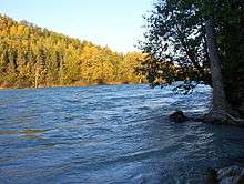 The silty glacial content of the river produces the milky blue coloration | |
| Country | US |
| Basin | |
| Main source | Tustumena Lake |
| River mouth |
Cook Inlet, Kenai Peninsula Borough, Alaska sea level |
| Physical characteristics | |
| Length | 17 miles (27 km) |
The Kasilof River (/kəˈsiːlɒf/ kə-SEE-lof) or Ggasilatnu in the Dena'ina language is a river on the western Kenai Peninsula in southern Alaska. The name is an anglicization of Reka Kasilova, the name given to the river by early Russian settlers in the area.[1] It begins at Tustumena Lake and flows northwest to Cook Inlet near Kasilof. The upper section of the river is very swift, with several sections considered Class II whitewater, and underwater hazards are difficult to detect, due to the silty nature of the glacial runoff that comprises most of the river. The entire river has powerful currents and is very cold. There is public access to the lower section from the Sterling Highway. Drift and bank fishing for salmon is popular on the lower Kasilof.[2]
See also
References
- ↑ U.S. Geological Survey Geographic Names Information System: Kasilof River
- ↑ The Milepost, 61st edition, page 616, ISBN 978-1892-15426-2
Coordinates: 60°23′19″N 151°18′11″W / 60.38861°N 151.30306°W