Kashihara, Nara
| Kashihara 橿原市 | ||
|---|---|---|
| City | ||
|
Kashihara Shrine | ||
| ||
 Location of Kashihara in Nara Prefecture | ||
 Kashihara Location in Japan | ||
| Coordinates: 34°31′N 135°48′E / 34.517°N 135.800°ECoordinates: 34°31′N 135°48′E / 34.517°N 135.800°E | ||
| Country | Japan | |
| Region | Kansai | |
| Prefecture | Nara Prefecture | |
| Government | ||
| • Mayor | Yutaka Morishita | |
| Area | ||
| • Total | 39.52 km2 (15.26 sq mi) | |
| Population (April 1, 2015) | ||
| • Total | 124,829 | |
| • Density | 3,176.79/km2 (8,227.8/sq mi) | |
| Symbols | ||
| • Tree | Oak | |
| • Flower | Common gardenia | |
| Time zone | Japan Standard Time (UTC+9) | |
| City hall address |
1-1-18 Yagi-chō, Kashihara-shi, Nara-ken 634-8586 | |
| Website |
www | |


Kashihara (橿原市 Kashihara-shi) is a city located in Nara Prefecture, Japan.
As of April 1, 2015, the city has an estimated population of 124,829, with 52,034 households.[1] Population density is around 3,176.79 persons per km², and the total area is 39.52 km².
The city was founded on February 11, 1956. The former mayor was Yutaka Asoda, who was elected to his third term of office in 2003. The present mayor is Yutaka Morishita, who was elected in 2007.
The exact spot of Emperor Jimmu's descent to earth was debated for centuries until in 1863 an area that is now part of the city was claimed to be the exact location. The city was the location of the Imperial capital Fujiwara-kyō, from 694 to 710.
At that time it was said to be one of the two richest cities of Japan: Umi no Sakai, Riku no Imai (tr. "by the sea, Sakai – inland, Imai" - Imai now being a part of Kashihara).
 Mount Unebi, one of Yamato Sanzan |
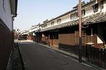 Imai area, built in around the 15th century |
Transport
Rail
- Kintetsu Railway
- Osaka Line: (<< for Osaka) - Masuga - Yamato-Yagi - Miminashi - (for Toba, Nagoya >>)
- Kashihara Line: (<< for Kyoto) - Ninokuchi - Yamato-Yagi - Yagi-nishiguchi - Unebigoryomae - Kashiharajingu-mae (line terminus)
- Minami Osaka Line: Bojo - Kashiharajingu-nishiguchi - Kashiharajingu-mae - (Yoshino Line >>)
- Yoshino Line: (<< Minami-Osaka Line) - Kashiharajingu-mae - Okadera - (Yoshino >>)
- West Japan Railway Company
- Sakurai Line: (<< for Yamatotakada) - Unebi - (for Nara >>)
Road
- Expressways
- Keinawa Expressway
 Japan National Route 24
 Japan National Route 165
 Japan National Route 166
 Japan National Route 169
See also
References
- ↑ "市町村別推計人口・世帯数". Nara Prefecture. April 1, 2015. Retrieved May 5, 2015.
External links
| Wikimedia Commons has media related to Kashihara, Nara. |
- Kashihara City official website (Japanese)
| Core city | ||
|---|---|---|
| Cities | ||
| Ikoma District | ||
| Kitakatsuragi District | ||
| Shiki District | ||
| Takaichi District | ||
| Uda District | ||
| Yamabe District | ||
| Yoshino District | ||