Karkar River
For the Syrian town, see Qarqar. For the island, see Karkar Island. For the Iranian village, see Karkar, Selseleh. For other uses, see Qarqar (disambiguation).
The Karkar (Azerbaijani: Qarqarçay, Armenian: Քարքար Karkar) is a river located de jure in Azerbaijan and de facto in Nagorno-Karabakh Republic, in the drainage basin of the Kura. Its length is 115 kilometres (71 mi), the area of the basin is 1,490 square kilometres (580 sq mi).[1] The river begins on the Karabakh Plateau at the altitude of 2,080 metres (6,820 ft) and is formed by the confluence of the rivers Zarysly and Khalfali.[1] The main tributaries are Ballyja, Badara and Daghdaghan. The Karkar is fed by the rain, snow and underground waters.
The Askeran fortress is situated on the banks of the Karkar.
- widths="220px"
 Karkar river
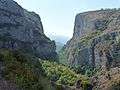 Canyon of the Karkar river
 Natural monument "Umbrella"
See also
| Wikimedia Commons has media related to Karkar River. |
Notes
| Major rivers | |
|---|---|
| Major lakes | |
| Major reservoirs | |
Coordinates: 40°09′32″N 47°32′06″E / 40.15889°N 47.53500°E
This article is issued from Wikipedia - version of the 6/15/2016. The text is available under the Creative Commons Attribution/Share Alike but additional terms may apply for the media files.