Kapoho, Hawaii
Coordinates: 19°30.164′N 154°50.762′W / 19.502733°N 154.846033°W
Kapoho, Hawaiʻi was a town in Puna district, Hawaiʻi County, Hawaiʻi, located near the eastern tip of the island of Hawaiʻi, in the easternmost end of the graben overlying Kīlauea's east rift zone.
Eruption of January 1960
On January 12, 1960 residents of Kapoho experienced over 1,000 small earthquakes shaking the area.[1] Deep cracks opened up in the street, and there are historic photos of residents inspecting the damage.[2]
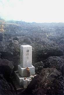
The eruption began on the night of the 13th, spilling lava out in the middle of a sugar cane field just above Kapoho. Although the main flow of lava flowed into the ocean, a slow-moving offshoot crept towards the town of Kapoho. Despite frantic efforts to divert the flow with earthen barricades or to harden it by spraying water on it, on January 28 the flow entered and buried the town. Nearly 100 homes and businesses as well as a hot spring resort were destroyed. The Cape Kumukahi Light east of the town was spared and continues in operation, but the keeper's dwellings were destroyed.
Kapoho today
There has been no lava activity in Kapoho now for over 50 years. While the original town is gone, the name Kapoho remains associated with the area. Today, the natural tide pools, black sand beach, and warm hot springs help make Kapoho an attractive spot to live and tourists to visit. Owing to these two factors, Kapoho is the most expensive area to live in Puna, with many homes costing over $1,000,000.[3]

See also
References
- Bendure, Glenda; Friary, Ned (September 1997). "Hawaii – The Big Island". Hawaii (4th ed.). Australia: Lonely Planet. p. 322. ISBN 0-86442-489-2.
External links
- See Ka-Wai-o-Pele
- The 1960 Kapoho Eruption of Kīlauea Volcano, Hawaiʻi at the Hawaiian Volcano Observatory website