Kapatagan, Lanao del Norte
| Kapatagan | |
|---|---|
| Municipality | |
|
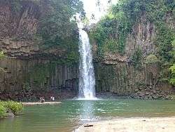
Cathedral Falls in Kapatagan | |
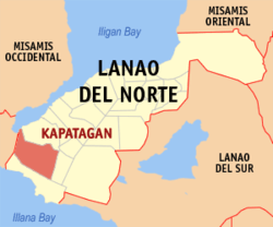 Map of Lanao del Norte with Kapatagan highlighted | |
.svg.png) Kapatagan Location within the Philippines | |
| Coordinates: 07°54′N 123°46′E / 7.900°N 123.767°ECoordinates: 07°54′N 123°46′E / 7.900°N 123.767°E | |
| Country | Philippines |
| Region | Northern Mindanao (Region X) |
| Province | Lanao del Norte |
| District | 2nd district of Lanao del Norte |
| Founded | July 5, 1949 |
| Barangays | 33 |
| Government[1] | |
| • Mayor | Benjie Y. Baguio |
| • Vice-Mayor | Perlito B. Gonzaga |
| Area[2] | |
| • Total | 242.89 km2 (93.78 sq mi) |
| Population (2010)[3] | |
| • Total | 53,916 |
| • Density | 220/km2 (570/sq mi) |
| Time zone | PST (UTC+8) |
| ZIP code | 9214 |
| Dialing code | +63 (0)63 |
| Income class | 2nd |
Kapatagan is a second class municipality in the province of Lanao del Norte, Philippines. According to the 2010 census, it has a population of 53,916 people.[3]
Geography
Kapatagan has a total land area of 25,048.41 hectares which include the area that is now being contested by the Municipality of Lala with an approximate area of 759 hectares.
Topography
On the southern and eastern sides of the locality are mountains which serve as natural barriers protecting the Municipality from typhoons. Offsetting the mountain is the presence of flat coastal lands and valley. Kapatagan has some rolling plains.
It has five (5) major rivers that flow to Panguil Bay, namely: Maranding, Panoloon, Butadon, Kidalos, and Balili. These rivers sometimes, especially during the rainy season, overflow causing floods resulting to destruction and even death of farm and land animals.
The Cathedral Falls and Sta. Cruz waterfalls are located at Barangays Cathedral Falls, Sta. Cruz, and Waterfalls respectively. At present, the spring supplies water into Poblacion and some neighboring barangays.
Climate
The Municipality has a tropical climate. Dry season starts during the month of October and ends in June. Wet season starts in the month of July and ends in December.
Barangays
Kapatagan is politically subdivided into 34 barangays.[2]
- Bagong Badian
- Bagong Silang
- Balili
- Bansarvil
- Belis
- Buenavista
- Butadon
- Cathedral Falls
- Concepcion
- Curvada
- De Asis
- Donggoan
- Durano
- Kahayagan
- Kidalos
- La Libertad
- Lapinig
- Mahayahay
- Malinas
- Maranding
- Margos
- Poblacion
- Pulang Yuta
- Quarry
- San Isidro
- San Vicente
- Santa Cruz
- Santo Tomas
- Suso
- Taguitic
- Tiacongan
- Tipolo
- Tulatulahan
- Waterfalls
Demographics
| Population census of Kapatagan | ||
|---|---|---|
| Year | Pop. | ±% p.a. |
| 1990 | 33,397 | — |
| 1995 | 37,006 | +1.94% |
| 2000 | 42,783 | +3.16% |
| 2007 | 49,134 | +1.93% |
| 2010 | 53,916 | +3.44% |
| Source: National Statistics Office[3] | ||
Economy
The municipality is beginning to gain economic favor mainly due to the funds released by some international organizations like GEM. Many companies will plan to build some stores in Kapatagan to boost its economic growth like Julies Bakeshop and Vina Shopping Center.
References
- ↑ "Official City/Municipal 2013 Election Results". Intramuros, Manila, Philippines: Commission on Elections (COMELEC). 1 July 2013. Retrieved 5 September 2013.
- 1 2 "Province: LANAO DEL NORTE". PSGC Interactive. Makati City, Philippines: National Statistical Coordination Board. Retrieved 7 July 2014.
- 1 2 3 "Total Population by Province, City, Municipality and Barangay: as of May 1, 2010" (PDF). 2010 Census of Population and Housing. National Statistics Office. Retrieved 7 July 2014.
External links
- Philippine Standard Geographic Code
- Philippine Census Information
- Official site of Kapatagan, Lanao del Norte
- Local Governance Performance Management System
 |
Panguil Bay | Lala | | |
| Aurora, Zamboanga del Sur | |
Sapad | ||
| ||||
| | ||||
| Sultan Naga Dimaporo |
Tubod (capital) | |
| Municipalities | |
| Highly urbanized city |
|