Kansas, Ohio
| Kansas, Ohio | |
|---|---|
| census-designated place | |
|
Community post office | |
 Location of Kansas, Ohio | |
| Coordinates: 41°14′42″N 83°17′05″W / 41.24500°N 83.28472°WCoordinates: 41°14′42″N 83°17′05″W / 41.24500°N 83.28472°W | |
| Country | United States |
| State | Ohio |
| County | Seneca |
| Township | Liberty |
| Time zone | Eastern (EST) (UTC-5) |
| • Summer (DST) | EDT (UTC-4) |
| ZIP codes | 44841 |
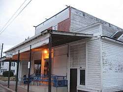
Kansas is a census-designated place in northwestern Liberty Township, Seneca County, Ohio, United States.[1] Although it is unincorporated, it has a post office, with the ZIP code of 44841.[2] It is located along State Route 635.[3]
Kansas was platted in early 1855 along a line of the Lake Erie and Louisville Railroad.[4] The community took its name from the Kansas Territory.[5] A short distance south of the community on State Route 635 is the Michaels Farm, which has been named a historic site.[6]
References
- ↑ U.S. Geological Survey Geographic Names Information System: Kansas, Ohio
- ↑ Zip Code Lookup
- ↑ DeLorme. Ohio Atlas & Gazetteer. 7th ed. Yarmouth: DeLorme, 2004, 37. ISBN 0-89933-281-1.
- ↑ Lang, William (1880). History of Seneca County, from the Close of the Revolutionary War to July, 1880. Springfield, Ohio: Transcript Printing Company. p. 550.
- ↑ Overman, William Daniel (1958). Ohio Town Names. Akron, OH: Atlantic Press. p. 67.
- ↑ National Park Service (2010-07-09). "National Register Information System". National Register of Historic Places. National Park Service.
Municipalities and communities of Seneca County, Ohio, United States | ||
|---|---|---|
| Cities | 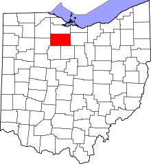 | |
| Villages | ||
| Townships | ||
| CDPs | ||
| Unincorporated communities | ||
| Ghost towns | ||
| Footnotes | ‡This populated place also has portions in an adjacent county or counties | |
This article is issued from Wikipedia - version of the 10/30/2016. The text is available under the Creative Commons Attribution/Share Alike but additional terms may apply for the media files.