Kangaroo Point, Queensland
| Kangaroo Point Brisbane, Queensland | |||||||||||||
|---|---|---|---|---|---|---|---|---|---|---|---|---|---|
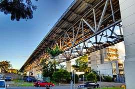 Kangaroo Point, underneath the Story Bridge | |||||||||||||
| Population | 7,000 (2011 census)[1] | ||||||||||||
| • Density | 5,400/km2 (13,900/sq mi) | ||||||||||||
| Postcode(s) | 4169 | ||||||||||||
| Area | 1.3 km2 (0.5 sq mi) | ||||||||||||
| LGA(s) | City of Brisbane | ||||||||||||
| Federal Division(s) | Griffith | ||||||||||||
| |||||||||||||
Kangaroo Point is a suburb of Brisbane, Queensland, Australia, located directly east across the Brisbane River from the Brisbane central business district. At the 2011 Australian Census the suburb recorded a population of 7,000.[1]
The suburb features two prominent attractions, the Story Bridge and Kangaroo Point Cliffs.
Geography
Kangaroo Point is located on a peninsula formed of harder rhyolite rock which the Brisbane River flows around. On the northern tip of the peninsula the Story Bridge connects it to the central business district and the suburb of Fortitude Valley. The suburb of Woolloongabba is located to the south. The six-lane Main Street runs from Story Bridge to Woolloongabba. The landscape of Kangaroo Point is predominantly high rise apartments towards the tip of the peninsula while the other end is predominantly low-medium density apartments and houses.
Attractions
Kangaroo Point is a popular recreation spot, conveniently close to the city and the South Bank Parklands. The Kangaroo Point Cliffs, situated on the east bank of the city bend of the Brisbane River north of the Maritime Museum, opposite Riverstage and the Queensland University of Technology at Gardens Point. The Look-out at Kangaroo Point is also included as one of the stops of the Brisbane City Council's City Sights bus service. Kangaroo Point is also home to one of less than 200 Mormon temples in the world {as of August 2015}. Kangaroo Point is also home to Ellis Street, one of the 20 steepest hills in Brisbane according to Brisbane City Council. Kangaroo Point is also home to the more-than-160-year-old St Mary's Anglican Church.

The cliffs are a popular picnic, rock climbing and abseiling site. The steepness of the cliffs was increased by quarrying operations which mined the volcanic rock or rhyolite lava flows which form the cliffs. The lava was deposited in the Triassic Period about 230 million years ago and filled up an ancient river valley. They currently form the banks of the Brisbane River.
The Story Bridge is a prominent landmark. It is able to be climbed with authorised tourist groups and provides the main means of access to the north of Brisbane. Directly under the bridge is the Story Bridge Hotel, and Yungaba, one of Brisbane's most unusual and iconic landmarks.[2]
The Kangaroo Point Natural History Project was implemented by the council in 2013 to recognise the contribution by some of Queensland's pioneering scientists and researchers from the area. Along a heritage trail through the CT White and James Warner parks are a series of signs and sculptures to commemorate their lives and work: Cyril Tenison White (government botanist), Frederick Manson Bailey (colonial botanist), Silvester Diggles (naturalist), Oscar Werner Tiegs (entomologist and zoologist), James Warner (surveyor), and Harry Oakman (landscape artist).[3]
Transport


By bus the suburb is serviced by the South East Busway transit line and buses along Main Street and Shafstons Avenue. By road Kangaroo Point residents rely on the Story Bridge and Captain Cook Bridge for access to the north, and the Southeast Freeway for access to the south. Main Street connects the Story Bridge through the suburb to the South East Freeway. Bicycle paths run along the Brisbane River from South Bank to and over the Story Bridge. The bicycle paths are heavily used by cyclists, roller skaters and pedestrians.
CityFerry service from the Eagle Street Pier in the CBD and the Sydney Street Pier in New Farm to Holman Street ferry wharf near the peak of Kangaroo Point, Thornton Street ferry wharf on the west side of the point, or Dockside ferry wharf on the east side. CityCat services do not directly service Kangaroo Point.[4]
The M7 Clem Jones Tunnel, a toll tunnel, which opened in March 2010, has a connection on Shafston Avenue. It diverts some traffic travelling through the suburb while providing an additional transport route for residents.
A green bridge was proposed in 2010 to the west to connect Kangaroo Point to the City and to the east to connect Kangaroo Point to Merthyr Road New Farm.[5] The Cross River Rail tunnel is planned to connect under Kangaroo Point Cliffs from Woolloongabba to an Albert Street railway station.
Demographics
In the 2011 census of Population and Housing, the population of Kangaroo Point postcode area was 7,000 people, in an area of 1.3 square kilometres.[1] The population was 48.3% females and 51.7% males. The median age of the Kangaroo Point population was 35 years of age, 2 years below the Australian median. 53.1% of people living in Kangaroo Point were born in Australia, compared to the national average of 69.8%; the next most common countries of birth were New Zealand 5.2%, England 4.4%, India 1.6%, Ireland 1.6%, Taiwan 1.2%. 69.6% of people spoke only English at home; the next most popular languages were 1.9% Mandarin, 1.8% Spanish, 0.9% Cantonese, 0.9% Nepali, 0.9% Italian. It has one of the city's highest proportion of residents living in flats, units or apartments (78.8%). Residents in stand alone houses make up only 16.6% of the population. 59.9% of residents are renters while only 18.7% fully own their dwelling. According to REIQ, the median house price in Kangaroo Point for the calendar year 2010 was $658,500.[6]
Education
Situated in Kangaroo Point is St. Joseph's Primary School which offers private schooling from grades 1 to 7. Although the suburb has no public schools to call its own, it is close to East Brisbane State School. For secondary/late primary school year entrancing, Kangaroo Point is close to St Laurence’s College, Anglican Church Grammar, All Hallows' School, Somerville House, Brisbane State High School and Villanova College. For tertiary studies, Kangaroo Point is host to campuses of Southbank Institute of TAFE (now demolished), Shafston University and the National Aboriginal Centre for the Performing Arts (ACPA). Directly across the river from the cliffs is the Queensland University of Technology (Gardens Point campus).
History


Before British settlement, Kangaroo Point was occupied by the Turrbal people.[7] It is one of the earliest suburbs settled in Brisbane and subsequently, is one of Brisbane's oldest suburbs, rich in history and character. It had a reputation for violent and rowdy street gangs around the 1900s, with a number of street riots.[8]
In 1823, explorer John Oxley described Kangaroo Point as a "jungle, fringed with mangroves with the higher land open forest, covered with grass". During the time of the subsequent convict settlement (1825–41), Kangaroo Point was cleared and used for cultivation of crops. Subsequently, the area was opened up for free settlement, the first land sales taking place on 13 December 1843. Among the early purchasers was Captain J.C.Wickham, the Police Magistrate. Surveyor James Warner built the first house at Kangaroo Point in 1844.[9]
Kangaroo Point's first school was opened in 1861 by the Church of England. It came under the control of the Board of Education in 1867 and consisted of a boys department and a girls department. A separate Girls and Infants school opened on 2 March 1874. This was replaced by the Kangaroo Point Girls School and the Kangaroo Point Infants School which both opened on 20 January 1890. The Kangaroo Point Boys School, Girls School and Infants School closed on 28 April 1950 and amalgamated to become the Kangaroo Point State School.[10] The Kangaroo Point State School closed on 30 June 1965.[11] It was located on the site of the old Southbank Institute of TAFE, on the corner of River Tce and Main St. In January 2010 this site was then redeveloped into parkland.
In 1887, the Yungaba Immigration Centre was built on Main Street at Kangaroo Point to replace the poor facilities at the existing centre in William Street.[12]
For many years the suburb was dominated by the factories of heavy engineering businesses, particularly those involved in the maritime industry, such as Evans Deakin, Buzzacott & Co and Evans Anderson & Phelan. Evans Deakin built the largest ship ever constructed on the Brisbane River, the 66,000 tonne oil tanker Robert Miller, which became adrift in the river during the 1974 Brisbane flood.[13] The last vessel to be built by Evans Deakin was an oil rig called Southern Cross. The company vacated the site in 1976,[13] with it later being redeveloped for high-rise accommodation.
Stone was quarried from the cliffs and used as building material. Until the 1930s, Evans Anderson & Phelan built steam locomotives at their Kangaroo Point works for Queensland Railways, however their works were not located near a railway, so the completed locomotives were delivered along Main Street on temporary track.
Until the federation of the Australian colonies in 1901, the Queensland Navy's main storage facility was located in the suburb. The first ship-based radio transmission in Australia was made between HMAS Gayundah and the buildings in 1903. The naval stores buildings were occupied by the Royal Australian Navy until 1959, and then by the Australian Army until 1984. The heritage-listed buildings are now used by an adventure company focussing on river activities and rock climbing.
The opening of the Story Bridge in July 1940 was the most significant development of the suburb. Trolleybuses operated by the Brisbane City Council linked the suburb with Fortitude Valley via the Story Bridge from 1953 to 1969, running along Main Street from Woolloongabba and other eastern suburbs.[14]
Heritage listings


Kangaroo Point has a number of heritage-listed sites, including:
- 34 Amesbury Street: former Naval Stores[15]
- 94 Baines Street: Raymond Park (West) Air Raid Shelter[16]
- 23 Castlebar Street: Shafston House[17]
- 116 Holman Street: Holman Street Ferry Terminal[18]
- 9 Leopard Street: Lamb House[19]
- Lower River Terrace: Kangaroo Point Cliffs[20]
- 76 Lower River Terrace: Cliffside Apartments[21]
- 102 Main Street: Yungaba Immigration Centre[12]
- 255 Main Street: Sunnyside[22]
- 261 - 267 Main Street: Silverwells[23]
- 433, 447 & 449 Main Street: St Mary's Anglican Church[24]
- 2 Scott Street: Scott Street Flats[25]
- 69 Shafston Avenue: Leckhampton[26]
- 330-334B Vulture Street: St Nicholas Russian Orthodox Cathedral[27]
- 184 Wellington Road: Raymond Park (East) Air Raid Shelter[28]
Notable people
- Frederick Manson Bailey, Australian botanist
- Peter Burge, Australian cricketer
- James Davis, convict and pioneer
- Silvester Diggles, Australian musician and ornithologist
- Graham K. Furness, Australian actor [29]
- Alec Hurwood, Australian cricketer
- John Lavarack, A Former Governor of Queensland
- Alfred John Raymond, alderman for Kangaroo Point and mayor of Brisbane in 1912
- Oscar Werner Tiegs, Australian zoologist
- Cyril Tenison White, Australian botanist
- Christopher Wrench, organist
- Charles Jackson Stewart,[30] (1876-1954) hotel keeper at the Criterion Hotel, George St.
- Frances Mallalieu Payne (1885-1976) artist and illustrator[31]
References
- 1 2 3 Australian Bureau of Statistics (31 October 2012). "Kangaroo Point (State Suburb)". 2011 Census QuickStats. Retrieved 14 March 2013.
- ↑ Kangaroo Point Brisbane Tourism Guide. Retrieved on 2013-11-07.
- ↑ "Kangaroo Point Natural History Project". Brisbane City Council. Retrieved 18 December 2013.
- ↑ Translink Ferry Map.
- ↑ "Brisbane, city of bridges?". Brisbane Times. Fairfax Media. 23 March 2010. Retrieved 14 March 2013.
- ↑ Kangaroo Point. REIQ Suburb profile. Retrieved 14 March 2013.
- ↑ Turrbal History
- ↑ "School of hard knocks on cliffs". The Sunday Mail. Queensland Newspapers. 10 January 2010. Retrieved 21 February 2011.
- ↑ Saint Mary's: Our Rich History
- ↑ BCM 1960 : Kangaroo Point State School in Main St
- ↑ Kangaroo Point State School
- 1 2 "Yungaba Immigration Depot (entry 600245)". Queensland Heritage Register. Queensland Heritage Council. Retrieved 6 July 2013.
- 1 2 McBride, Frank; et al. (2009). Brisbane 150 Stories. Brisbane City Council Publication. pp. 250–251. ISBN 978-1-876091-60-6.
- ↑ Clark, H.R.; Keenan, D.R. (1977). Brisbane's tramways: The last decade. Transit Press. ISBN 978-0-909338-01-5.
- ↑ "Naval Stores (former) (entry 600239)". Queensland Heritage Register. Queensland Heritage Council. Retrieved 6 July 2013.
- ↑ "Raymond Park (West) Air Raid Shelter (entry 602478)". Queensland Heritage Register. Queensland Heritage Council. Retrieved 6 July 2013.
- ↑ "Shafston House (entry 600241)". Queensland Heritage Register. Queensland Heritage Council. Retrieved 6 July 2013.
- ↑ "Holman Street Ferry Terminal (entry 602445)". Queensland Heritage Register. Queensland Heritage Council. Retrieved 6 July 2013.
- ↑ "Home (entry 600242)". Queensland Heritage Register. Queensland Heritage Council. Retrieved 6 July 2013.
- ↑ "Kangaroo Point Cliffs (entry 602400)". Queensland Heritage Register. Queensland Heritage Council. Retrieved 6 July 2013.
- ↑ "Cliffside Apartments (entry 601650)". Queensland Heritage Register. Queensland Heritage Council. Retrieved 6 July 2013.
- ↑ "Sunnyside (entry 601810)". Queensland Heritage Register. Queensland Heritage Council. Retrieved 6 July 2013.
- ↑ "Silverwells (entry 600243)". Queensland Heritage Register. Queensland Heritage Council. Retrieved 6 July 2013.
- ↑ "St Mary's Anglican Church (entry 600244)". Queensland Heritage Register. Queensland Heritage Council. Retrieved 6 July 2013.
- ↑ "Scott Street Flats (entry 601171)". Queensland Heritage Register. Queensland Heritage Council. Retrieved 6 July 2013.
- ↑ "Leckhampton (entry 600246)". Queensland Heritage Register. Queensland Heritage Council. Retrieved 6 July 2013.
- ↑ "St Nicholas Russian Orthodox Cathedral (entry 600358)". Queensland Heritage Register. Queensland Heritage Council. Retrieved 6 July 2013.
- ↑ "Raymond Park (East) Air Raid Shelter (entry 602479)". Queensland Heritage Register. Queensland Heritage Council. Retrieved 6 July 2013.
- ↑ YouTube - Graham.K.Furness "Weakest Link " Australia Quiz Show Channel 7
- ↑ Cook, Margaret (2002). "Stewart, Charles Jackson (1876–1954)". Australian Dictionary of Biography.
- ↑ Philp, Angela (2000). "Payne, Frances Mallalieu (Frank) (1885–1976)". Australian Dictionary of Biography. Retrieved 30 March 2015.
External links
- University of Queensland: Queensland Places: Kangaroo Point
- Information on the naval stores from the Queensland Heritage Register
Coordinates: 27°28′S 153°02′E / 27.467°S 153.033°E