Kandahar Province
| Kandahar Pashto: کندهار ولايت Persian: ولایت قندهار | |
|---|---|
| Province | |
|
View of Arghandab River Valley | |
| Nickname(s): Loy kandahar | |
 Map of Afghanistan with Kandahar highlighted | |
| Coordinates (Capital): 31°00′N 65°30′E / 31.0°N 65.5°ECoordinates: 31°00′N 65°30′E / 31.0°N 65.5°E | |
| Country |
|
| Founded by | Alexander the Great |
| Capital | Kandahar |
| Government | |
| • Governor | Humayoon Azizi |
| Area | |
| • Total | 54,022 km2 (20,858 sq mi) |
| Population (2012)[1] | |
| • Total | 1,151,100 |
| • Density | 21/km2 (55/sq mi) |
| Time zone | UTC+4:30 |
| Area code(s) | AF-KAN |
| Main languages | Pashto |

Kandahar (Pashto: کندھار) / (Persian: قندهار) is one of the thirty-four provinces of Afghanistan, located in the southern part of the country next to Pakistan. It is surrounded by Helmand in the west, Uruzgan in the north and Zabul Province in the east. Its capital is the city of Kandahar, which is located on the Arghandab River.
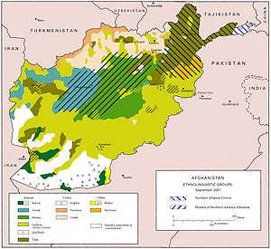
The province contains about 18 districts, over 1,000 villages, and approximately 1,151,100 people, which is mostly tribal and a rural society. The main inhabitants of Kandahar province are the native ethnic Pashtuns, although smaller communities of Tajiks, Hazaras, Uzbeks and Baloch are also found in parts of the city of Kandahar. The current governor of the province is Toryalai Wesa.
Name
There is speculation about the origin of the name "Kandahar". It is believed that Kandahar bears Alexander's name, and derives from the Pashto rendering of Iskandariya or Alexandria.[2] A temple to the deified Alexander as well as an inscription in Greek and Aramaic by the emperor Ashoka, who lived a few decades later, have been discovered in the old citadel.[3]
History
Excavations of prehistoric sites by archaeologists such as Louis Dupree and others suggest that the region around Kandahar is one of the oldest human settlements known so far.
"...Early peasant farming villages came into existence in Afghanistan ca. 5000 B.C., or 7000 years ago. Deh Morasi Ghundai, the first prehistoric site to be excavated in Afghanistan, lies 27 km (17 mi.) southwest of Kandahar (Dupree, 1951). Another Bronze Age village mound site with multiroomed mud-brick buildings dating from the same period sits nearby at Said Qala (J. Shaffer, 1970). Second millennium B.C. Bronze Age pottery, copper and bronze horse trappings and stone seals were found in the lowermost levels in the nearby cave called Shamshir Ghar (Dupree, 1950). In the Seistan, southwest of these Kandahar sites, two teams of American archaeologists discovered sites relating to the 2nd millennium B.C. (G. Dales, University Museum, University of Pennsylvania, 1969, 1971; W, Trousdale, Smithsonian Institution, 1971 – 76). Stylistically the finds from Deh Morasi and Said Qala tie in with those of pre-Indus Valley sites and with those of comparable age on the Iranian Plateau and in Central Asia, indicating cultural contacts during this very early age..."[4]
The area was called Arachosia and was a frequent target for conquest because of its strategic location in Asia, which connects Southern, Central and Southwest Asia. It was part of the Medes territory before falling to the Achaemenids. In 330 BC it was invaded by Alexander the Great and became part of the Seleucid Empire following his death. Later it came under the influence of the Indian emperor Ashoka, who erected a pillar there with a bilingual inscription in Greek and Aramaic. The territory was ruled by the Zunbils before Arabs of the Umayyad Caliphate arrived in the 7th century.
"The Arabs advanced through Sistan and conquered Sindh early in the eighth century. Elsewhere however their incursions were no more than temporary, and it was not until the rise of the Saffarid dynasty in the ninth century that the frontiers of Islam effectively reached Ghazni and Kabul. Even then a Hindu dynasty the Hindushahis, held Gandhara and eastern borders. From the tenth century onwards as Persian language and culture continued to spread into Afghanistan, the focus of power shifted to Ghazni, where a Turkic dynasty, who started by ruling the town for the Samanid dynasty of Bokhara, proceeded to create an empire in their own right. The greatest of the Ghaznavids was Mahmud who ruled between 998 and 1030. He expelled the Hindus from Ghandhara."[5]
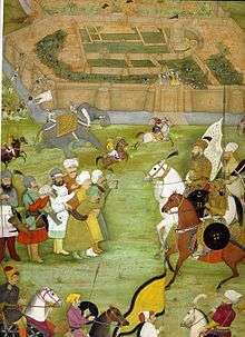
Mahmud of Ghazni made the area part of the Ghaznavids in the 10th century, who were replaced by the Ghurids. After the destructions caused by Genghis Khan in the 13th century, the Timurids established rule and began rebuilding cities. From about 1383 until his death in 1407, Kandahar was governed by Pir Muhammad, a grandson of Timur. By the early 16th century, it fell to Babur briefly. From then on the province was controlled as their easternmost territories by the Shia Safavids, who regularly had wars with the Sunni Mughals over the region, until the rise of Mir Wais Hotak in 1709. He rebelled against the Safavids and established the Hotaki dynasty which became a powerful Afghan empire until 1729 when Nader Shah declared war on the Ghilzai rulers. By 1738 the last Hotaki ruler Shah Hussain was defeated in what is now Old Kandahar.
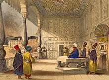
Ahmad Shah Durrani, the founding father of Afghanistan, gained control of the province in 1747 and made the city of Kandahar the capital of his new Afghan Empire. In the 1770s, the capital of the empire was transferred to Kabul. Ahmad Shah Durrani's mausoleum is located in the center of the city.
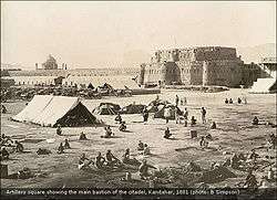
British-led Indian forces occupied the province during the First Anglo-Afghan War from 1832 to 1842. They also occupied the city during the Second Anglo-Afghan War from 1878 to 1880. It remained peaceful for about 100 years until the late 1970s.
During the Soviet occupation of 1979 to 1989, Kandahar province witnessed many fights between Soviet and local Mujahideen rebels. After the Soviet withdrawal the city fell to Gul Agha Sherzai, who became a powerful warlord and controlled the province.
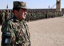
At the end of 1994, the Taliban took over the area and set out to conquer the rest of Afghanistan. Since the removal of the Taliban government in late 2001, Kandahar again came under the control of Gul Agha Sherzai. He was replaced in 2003 by Yousef Pashtun followed by Asadullah Khalid and others. In the meantime, the United States established bases in the province. The various soldiers of International Security Assistance Force (ISAF) are also housed in the bases. The main base is at Kandahar International Airport. Their main objective is to train the Afghan National Security Forces (ANSF) as well as build government institutions and assist the local population.
In spring 2010, the province as well as its capital city became a target of American operations following Operation Moshtarak in neighbouring Helmand province.[6] Kandahar has been the site of much of the violence in the War on Terror in Afghanistan.
Politics and governance

Gul Agha Sherzai was Governor of the province before and after the Taliban government, until early 2003, when mounting criticism of his efforts led President Hamid Karzai to transfer him from Kandahar to Jalalabad as Governor of Nangarhar Province. Sherzai was replaced by Yousef Pashtun, who was an Engineer by profession and a strong Afghan Intellectual.
In 2005, when President Karzai won the first Afghan Presidential Elections, he appointed Yousef Pashtun as the Minister of Urban Development. After Pashtun, Asadullah Khalid governed the province until the appointment of Rahmatullah Raufi in August 2008.[7] Raufi was replaced by Toryalai Wesa in December 2008. Humayun Azizi replaced Toyalai Wesa in 2014 and is the current governor of Kandahar Province.
Demographics

The population of the province is about 1,151,100,[1] which is mostly tribal and a rural society. The inhabitants of Kandahar province are ethnic Pashtuns, although smaller communities of Tajiks, Hazaras, Uzbeks and Baloch are also found in parts of the city of Kandahar. The main language spoken in the province is Pashto but in some urban centers Dari (Afghan Persian) is also in use as a second language.
Tribes
The main tribes in the province are as follows:[8]
- Durrani
- Barech
- Popalzai
- Alikozai
- Barakzai
- Achakzai
- Ghilzai
- Kakar
- Babai
- Tokhi
- Nurzai
- Hotak
- Taraki
- Loudin
- Brahui
District information
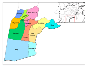
| District | Capital | Population[9] | Area | Number of villages and ethnic groups |
|---|---|---|---|---|
| Arghandab | 53,205 | 578 km2 | 79 villages. Pashtun.[10] | |
| Arghistan | 28,900 | 3,908 km2 | Pashtun.[11] | |
| Daman | 24,800 | [12] | ||
| Ghorak | 80,000 | 1,503 km2 | Pashtun.[13] | |
| Kandahar | Kandahar | 512,200 | ||
| Khakrez | 15,074 | 1,616 km2 | Pashtun.[14] | |
| Maruf | 27,700 | 3,191 km2 | Pashtun.[15] | |
| Maywand | 58,254 | 2,858 km2 | 160 villages. 95% Pashtun and 5% other.[16] | |
| Miyanishin | 12,600 | 917 km2 | Pashtun.[17] | |
| Nesh | 11,300 | 1,302 km2 | Pashtun.[18] | |
| Panjwayi | 82,800 | |||
| Reg | 1,600 | |||
| Shah Wali Kot | 36,400 | |||
| Shorabak | 9,600 | |||
| Spin Boldak | 41,000 | |||
| Zhari | 49,500 | |||
| Shaga | ||||
| Dand |
Transport and economy

Kandahar International Airport is located east of the city of Kandahar. It is designed for military and civilian use. It serves the population of the entire southern Afghanistan by providing domestic and international flights to Dubai, Pakistan, Iran and other regional countries. The airport was built by the United States in the 1960s under the United States Agency for International Development program. It was heavily used by Soviet and Afghan forces during the 1980s and again during the 2001-present NATO-led war. The airport was upgraded and expanded during the last decade by the United States Army Corps of Engineers.
There is currently no rail service but reports indicate that at least one will be built between the city of Kandahar and the border town of Spin Boldak in the south, which will then connect with Pakistan Railways. All transporting of goods are done by trucks and cars. A number of important roads run through the province and this helps the area's economy. The town of Spin Boldak serves as a major transporting, shipping, and receiving site. It is being developed so that trade with neighboring Pakistan increases.
Kandahar province has bus services to major towns and village headquarters. Its capital, Kandahar, has a public bus service that take commuters on daily routes to different destinations throughout the city. Besides the buses, there are yellow and white taxicabs that provides transportation service inside the city as well as throughout the province. Other traditional methods of ground transportation are also used. Private vehicles are on the rise in the country, with large showrooms selling new or second-hand vehicles imported from the United Arab Emirates. More people are buying new cars as the roads and highways are being improved.
Kandahar has been known for having well-irrigated gardens and orchards, and was famous for its grapes, melons, and pomegranates. The main source of trade is to Pakistan, Iran and other regional countries. Kandahar is an agricultural area and several of the districts are irrigated by the Helmand and Arghandab Valley Authority.[19] The Dahla Dam is located in the province, north of the city of Kandahar.
Healthcare
The percentage of households with clean drinking water fell from 64% in 2005 to 32% in 2011.[20] The percentage of births attended to by a skilled birth attendant fell from 16% in 2005 to 14% in 2011.[20]
Education

The overall literacy rate (6+ years of age) fell from 16% in 2005 to 7% in 2011.[20] The overall net enrolment rate (6–13 years of age) fell from 23% in 2005 to 11% in 2011.[20]
Kandahar University is one of the largest educational institutions in the province. It has over 5,000 students, about 300 of which are female students.[21] In partnership with the Asia Foundation, Kandahar University conducted a pilot project that provided female high school graduates with a four-month refresher course to prepare for the college entrance examination. The university is only one of two universities in Kandahar that serve all of southern Afghanistan. The conditions in the university are poor but improving slowly. The university is far behind the universities of the North because of the violence, the two universities in southern Afghanistan also receive very limited funding.
Efforts to improve education in Afghanistan are severely hampered with shortage of books. Lack of funding, and political will, has led to only small gains since the fall of the Taliban. Education has moved somewhat upward in the rest of the country, but southern provinces, like Kandahar, have seen slow progress because of the continued fighting and instability of the region. In 2006 alone, almost 150 educational institutes have closed in Kandahar province alone, according to the education ministry. Regionally more than 50 schools have been attacked this year. Over 60,000 students cannot attend school because of the risk of attack. Some of the well known schools in Kandahar are Ahmad Shah Baba High School, Zarghuna Ana High School, Mir Wais High School, Shah Mahmud High School, and Mahmud Tarzi High School, Afghan Turk High Schools.
Notable people from Kandahar Province
- Ahmad Shah Durrani - Founding father of Afghanistan (Father of the Nation)
- Timur Shah Durrani - Second ruler of the Durrani Empire
- Zaman Shah Durrani - Third ruler of the Durrani Empire
- Ghulam Haider Hamidi - Mayor of Kandahar who was killed in July 2011
- Abdul Aziz Hotak - Second ruler of the Hotaki dynasty
- Mir Wais Hotak - Founder of Hotaki dynasty
- Ashraf Hotaki – Shah of Persia (1725-1729)
- Hussain Hotaki – Last ruler of the Hotaki dynasty
- Mahmud Hotaki - Third ruler of the Hotaki dynasty and Shah of Persia
- Nur Jahan - Empress of the Mughal Empire
- Abdul Bari Jahani - Poet, writer, author of the Afghan National Anthem
- Abdul Ahad Karzai - Former tribal leader of Popalzai tribe, former Deputy Speaker of Afghan Parliament
- Hamid Karzai - President of Afghanistan
- Abdur Rahman Khan - King of Afghanistan
- Ayub Khan - Defeated British Troops in Second Anglo-Afghan War
- Dost Mohammad Khan - Founder of the Barakzai dynasty/Emire of Afghanistan
- Sher Ali Khan - Emir of Afghanistan
- Mohammad Hashim Maiwandwal - Prime Minister of Afghanistan
- Yahya Maroofi - Secretary General of ECO
- Mohammad Arif Noorzai - tribal leader, former Deputy Speaker of Afghan Parliament
- Yousef Pashtun - Senior Advisor to President, Former Minister of Urban Development, Former Governor of Kandahar Province
- Gul Agha Sherzai - Governor of Nangarhar Province
- Toryalai Wesa - Governor of Kandahar Province
- Abdul Hai Habibi- Poet, Writer, Historian, Founder and Developer of Academic Pashto era.
See also
References
- 1 2 "Settled Population of Kandahar province by Civil Division, Urban, Rural and Sex-2012-13" (PDF). Retrieved 2012-10-20.
- ↑ "Alexander the Great: his towns - Alexandria in Arachosia". Livius.org.
- ↑ http://www.livius.org/a/pakistan/shahbazgarhi/shahbazgarhi2.html
- ↑ Dupree, Nancy Hatch (1970). An Historical Guide to Afghanistan. First Edition. Kabul: Afghan Air Authority, Afghan Tourist Organization. p. 492. Retrieved 2012-06-17.
- ↑ Afghanistan: a new history By Martin Ewans Edition: 2, illustrated Published by Routledge, 2002 Page 15 ISBN 0-415-29826-1, ISBN 978-0-415-29826-1
- ↑ "Kandahar Becomes Battlefield Before a U.S. Offensive"
- ↑ Galloway, Gloria (23 August 2008). "Security chief concern for new Kandahar governor". The Globe and Mail.
- ↑ Afghanistan's Provinces - Kandahar at NPS
- ↑ "Kandahar Province". Government of Afghanistan and United Nations Development Programme (UNDP). Ministry of Rural Rehabilitation and Development. Retrieved 2012-11-04.
- ↑ "Arghandab District" (PDF). Retrieved 2013-06-24.
- ↑ "Arghistan District" (PDF). Retrieved 2013-06-24.
- ↑ "Daman District (Updated DDP)" (PDF). Retrieved 2013-06-24.
- ↑ "Ghorak District" (PDF). Retrieved 2013-06-24.
- ↑ "Khakriz District" (PDF). Retrieved 2013-06-24.
- ↑ "Maruf District" (PDF). Retrieved 2013-06-24.
- ↑ "Maiwand District" (PDF). Retrieved 2013-06-24.
- ↑ "Mianishin District" (PDF). Retrieved 2013-06-24.
- ↑ "Nish District" (PDF). Retrieved 2013-06-24.
- ↑ "The Helmand Valley Project in Afghanistan: A.I.D. Evaluation Special Study No. 18" (PDF). C. Clapp-Wicek & E. Baldwin, U.S. Agency for International Development. December 1983.
- 1 2 3 4 Archive, Civil Military Fusion Centre, https://www.cimicweb.org/AfghanistanProvincialMap/Pages/Kandahar.aspx
- ↑ "Kandahar University Goes Solar". November 3, 2012. Retrieved 2012-11-05.
Further reading
- Vogelsang, W. (1985). Early historical Arachosia in South-east Afghanistan; Meeting-place between East and West.
- Dupree, Louis. (1973) Afghanistan. Princeton: Princeton University Press.
- Rashid, Ahmed. (2000) Taliban: Militant Islam, Oil, and Fundamentalism in Central Asia. New Haven, CT: Yale University Press.
External links
| Wikimedia Commons has media related to Kandahar Province. |
 |
Uruzgan Province | Zabul Province | | |
| Helmand Province | |
|||
| ||||
| | ||||
| Balochistan, |