Kamo, Niigata
| Kamo 加茂市 | |||
|---|---|---|---|
| City | |||
|
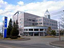
Kamo City Hall | |||
| |||
 Location of Kamo in Niigata | |||
 Kamo
| |||
| Coordinates: 37°39′58.7″N 139°2′24.8″E / 37.666306°N 139.040222°ECoordinates: 37°39′58.7″N 139°2′24.8″E / 37.666306°N 139.040222°E | |||
| Country | Japan | ||
| Region | Chūbu (Kōshin'etsu) (Hokuriku) | ||
| Prefecture | Niigata | ||
| Government | |||
| • -Mayor | Kiyohiko Koike | ||
| Area | |||
| • Total | 133.72 km2 (51.63 sq mi) | ||
| Population (June 2016) | |||
| • Total | 27,500 | ||
| • Density | 206/km2 (530/sq mi) | ||
| Time zone | Japan Standard Time (UTC+9) | ||
| Symbols | |||
| • Tree | Cryptomeria | ||
| • Flower | Camellia japonica | ||
| Phone number | 0256-52-0080 | ||
| Address | 2-3-5, Saiwai-cho, Kamo-shi, Niigata-ken 959-1392 | ||
| Website |
www | ||


Kamo (加茂市 Kamo-shi) is a city located in north-central Niigata Prefecture, in the Hokuriku region of Japan. As of 1 June 2016, the city had an estimated population of 27,500 and a population density of 206 persons per km². Its total area was 133.72 square kilometres (51.63 sq mi).
Geography
Kamo is located in an inland region of north-central Niigata Prefecture. As the city name implies, the Kamo River flows through the city. The highest elevation is the summit of Mount Awagatake at 1292 meters. The city roughly halfway between the two larger cities of Nagaoka and Niigata.
Surrounding municipalities
History
The area of present-day Kamo was part of ancient Echigo Province, and developed from the early Heian period as settlement associated with a branch of the Kamo Shrine in Kyoto. The modern town of Kamo was established within Kitakanbara District, Niigata with the establishment of the municipalities system on April 1, 1889. It was elevated to city status on March 10, 1954.
Economy
Kamo is traditionally associated with its production of kiri-tansu, a type of tansu chest-of-drawers made from paulownia wood.
Education
Colleges and universities
Primary and secondary education
Kamo has seven public elementary schools and five public middle schools. There are three public high schools.
Transportation
Railway
Highway
Sister cities
Kamo maintains sister city ties with three cities:
 Ōshima, Japan (1968)
 Zibo, China[1] friendship city since October 21, 1993
 Komsomolsk-on-Amur, Russia[1]
Local attractions
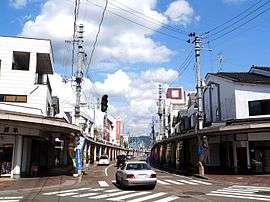
Kamo is a popular place for small tour groups, especially for children in elementary school. It is advertised as a "traditional town" and sometimes referred to as the Little Kyoto of the Hokuetsu region. This is because it shares certain structural features with Kyoto, being surrounded on three sides by mountains and intersected by a river. Kamo's most famous attraction is Kamoyama Park, which is home to the Omi Jinja (Shrine) and many other sights, including a petting area for small squirrels which the town has regularly imported. The Kamo River is also the site of many city events, including the Obon Festival in August and the Snow Camelia Festival in April. The snow camelia is a symbol of Kamo and can be seen growing in many locations around the city.
Noted people from Kamo
- Hirohiko Izumida (governor of Niigata Prefecture)
- Makiko Kikuta (politician)
- Kanako Higuchi (actress)
- Shigeo Gochō (Photographer)
- Nobuo Kawaguchi (football player)
References
- 1 2 Prefecture "International Exchange" Check
|url=value (help). List of Affiliation Partners within Prefectures. Council of Local Authorities for International Relations (CLAIR). Retrieved 1 July 2016.
External links
| Wikimedia Commons has media related to Kamo, Niigata. |
- Official website (Japanese)