Kamena Vourla
| Kamena Vourla Καμένα Βούρλα | |
|---|---|
 | |
 Kamena Vourla | |
|
Location within the regional unit  | |
| Coordinates: 38°47′N 22°47′E / 38.783°N 22.783°ECoordinates: 38°47′N 22°47′E / 38.783°N 22.783°E | |
| Country | Greece |
| Administrative region | Central Greece |
| Regional unit | Phthiotis |
| Municipality | Molos-Agios Konstantinos |
| • Municipal unit | 117.5 km2 (45.4 sq mi) |
| Population (2011)[1] | |
| • Municipal unit | 4,728 |
| • Municipal unit density | 40/km2 (100/sq mi) |
| Community[1] | |
| • Population | 2,796 (2011) |
| Time zone | EET (UTC+2) |
| • Summer (DST) | EEST (UTC+3) |
| Postal code | 35008 |
| Vehicle registration | ΜΙ |
| Website |
www |
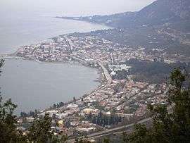
Kamena Vourla (Greek: Καμένα Βούρλα, lit. “Burnt Rushes”) is a town and a former municipality in Phthiotis, Greece. Since the 2011 local government reform it is part of the municipality Molos-Agios Konstantinos, of which it is the seat and a municipal unit.[2] The municipal unit has an area of 117.496 km2.[3] The population of the town proper was 2,796 at the 2011 census. The town was formerly known as Palaiochori.
Geography
Kamena Vourla is located on the south coast of the Malian Gulf, 4 km (2 mi) west of Cape Knimis, which separates the Malian Gulf from the North Euboean Gulf. The Knimis mountains rise just south of the town. It is crossed by Motorway 1, which connects Athens and Thessaloniki.
Springs and monastery
The famous springs became important around 1926 when the chemist Michail Pertesis discovered the exceptionally high radon concentration in the water, which was thought of as a great value for people's health. Nearly ten years later (1930s), the first hotels started to develop. After World War II, Kamena Vourla was transformed into a tourist attraction.
8 kilometres (5 miles) away on the road heading uphill features the monastery known as Iera Moni Metamorfoseos tou Sotiros which was built in around the 11th century. Nearby the city a historic tomb is situated, a monument to the Battle of Thermopylae with a seal of Leonidas, King of Sparta, located not far from the mountain village Karya.
External links
- http://www.kammenavourla.gr Kamena Vourla Portal & Guide
- http://www.kamena-vourla.gr Kamena Vourla Hot Springs Information, Facilities, Directions, near destinations
References
- 1 2 "Απογραφή Πληθυσμού - Κατοικιών 2011. ΜΟΝΙΜΟΣ Πληθυσμός" (in Greek). Hellenic Statistical Authority.
- ↑ Kallikratis law Greece Ministry of Interior (Greek)
- ↑ "Population & housing census 2001 (incl. area and average elevation)" (PDF) (in Greek). National Statistical Service of Greece.