Kamaran
Coordinates: 15°21′N 42°34′E / 15.350°N 42.567°E
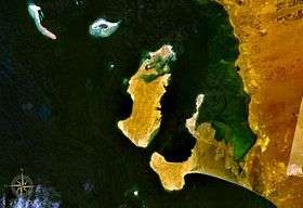

Kamaran Island (Arabic: كمران Kamarān) is the largest Yemen-controlled island in the Red Sea. The 108 km2 (42 sq mi) island is 18 km (11 mi) long and 7 km (4.3 mi) wide and is strategically located at the southern end of the Red Sea. [1] It is a "shelf island" located in the shallow waters of the Arabian peninsula's continental shelf with coral reefs surrounding three sides of the island. The population numbers 2,200.[2]
Kamaran is generally flat, with a few hills in the south. Its highest point is Jabal Yaman (24 meters high), situated about three kilometers from Ra's al Yaman, the southeastern cape of the island.
History
General
Kamaran had been inhabited for centuries when the Portuguese established an outpost there in the 16th century. The island was occupied by the Ottoman Empire in the 19th century and used as a quarantine station for pilgrims conducting the hajj to the Ottoman-controlled Muslim holy city of Mecca.
In June 1915, during World War I, the Idrisi army seized the island and gave it to the British Aden Province as a barganing tool. While Aden continued to administer it, it did not declare formal possession. In 1923, the Treaty of Lausanne, which divided up the defeated Ottoman Empire, declared an end to its sovereignty over the island and that its future was to be "settled by the parties concerned" without specifying those parties. Britain continued to occupy the island despite the objections of Yemen and administered it from the Colony of Aden. In 1949, Britain formally declared the governor of Aden to be the governor of Kamaran but the island did not become a part of the colony.[3]
On 30 November 1967, Kamaran became a part of the People's Democratic Republic of Yemen (South Yemen) upon its independence from Britain, but was seized by the adjacent Yemen Arab Republic (North Yemen) in 1972[4] and became a part of a unified Yemen in 1990.
British Commissioners
- June 1915 - 191. D.G.L. Shaw - Commander
- 191. - 1930's Captain Wickham.
- 1930's - c.1945 David Thompson
- c.1945 - 1952 Major Thomson British Army 1948
- 1952 - 1954? R.G.W.E. Alban (b. 1899 - d. 19..)
- 1954? - 30 November 1967 Wilson
Postal history
Kamaran Island had an Ottoman post office until 1915 and had a sub-post office of Aden beginning in 1924. From 1967, it was a postal territory of South Yemen, from 1972 of North Yemen, and from 1990 of the reunified Republic of Yemen.
Notes
- ↑ The source for the area figure is "Island Directory". UN System-wide Earthwatch.. Various other sources give significantly different figures including 181, 130, and 57 km2 (22 sq mi). This photo from the period of British rule gives a figure of 207 km2 (80 sq mi).
- ↑ Farlex Encyclopedia
- ↑ The Kamaran Order in Council, 1949 (SI 1949/137)
- ↑ Daniel McLaughlin, Yemen: The Bradt Travel Guide (2007) pp.162-3. ISBN 1-84162-212-5
Sources and External links
- WorldStatesmen- Yemen
- Kamaran Island page
- Kamaran Island Photo Gallery
- Nigel Groom. The island of two moons: Kamaran 1954. at The British-Yemeni Society webpage
- Small Islands in the Near East
| Socotra Archipelago | |
|---|---|
| Hanish Islands |
|
| Uninhabited islands | |