Kaltwasserkarspitze
| Kaltwasserkarspitze | |
|---|---|
|
The Kaltwasserkarspitze from the east | |
| Highest point | |
| Elevation | 2,733 m (AA) (8,967 ft) |
| Prominence | 2,733-2,413 m ↓ Hochjöchl |
| Isolation | 1.3 km → Birkkarspitze |
| Coordinates | 47°24′10″N 11°27′02″E / 47.40278°N 11.45056°ECoordinates: 47°24′10″N 11°27′02″E / 47.40278°N 11.45056°E |
| Geography | |
| State/Province | AT-7 |
| Parent range | Hinterautal-Vomper Chain, Karwendel |
| Climbing | |
| First ascent | 15 August 1870 by Hermann von Barth |
| Normal route | Scharnitz – Kastenalm – south arête (II) |
 The Kaltwasserkarspitze from the Birkkarspitze | |
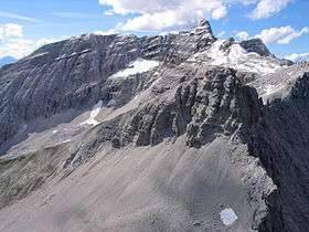

The Kaltwasserkarspitze is a mountain in the Hinterautal-Vomper Chain and, at 2,733 m (AA) m, is the fourth highest peak in the Karwendel mountains in Austria after the Birkkarspitze, Middle and Eastern Ödkarspitze. The Kaltwasserkarspitze is the eastern neighbour of the Birkkarspitze, its rugged summit dropping in a steep rock face to the valley of Kleiner Ahornboden. A long arête heads south from the mountain, on which are the Sägezähne ("saw teeth") and the Großer Heißenkopf (2,431 m (AA)) and which separates the Östliche Birkkar from the Raukarl.
The mountain was first climbed in 1870 by Hermann von Barth.
Ascent
The Kaltwasserkarspitze is not easy to reach. All routes involve sections of UIAA climbing grade II:
- From the Hinterau valley up the south arête, crossing of the Großer Heißenkopf and the Sägezähne
- From the Hinterau valley through the Birkkarklamm gorge and the Östliche Birkkar
- From Karwendelhaus via the Hochjöchl saddle (2,413 m (AA))
- From Kleiner Ahornboden via the Sauissköpfl, Western Moserkarscharte col and through the Raukarl to the south arête
External links
| Wikimedia Commons has media related to Kaltwasserkarspitze. |
- Lithograph "Im wilden Felsgebirg" with the Kaltwasserkarspitze by Ernst Platz (1912)
This article is issued from Wikipedia - version of the 2/21/2016. The text is available under the Creative Commons Attribution/Share Alike but additional terms may apply for the media files.