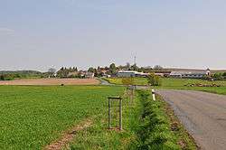
Kakejcov
| Kakejcov | |||
|---|---|---|---|
| Municipality | |||
 | |||
| |||
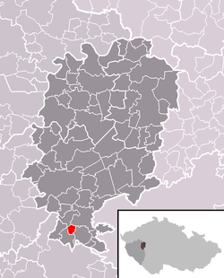 Location of Kakejcov within Rokycany District | |||
 Kakejcov Location of Kakejcov within Czech Republic | |||
| Coordinates: 49°40′2″N 13°37′39″E / 49.66722°N 13.62750°ECoordinates: 49°40′2″N 13°37′39″E / 49.66722°N 13.62750°E | |||
| Country |
| ||
| Region | Plzeň | ||
| District | Rokycany | ||
| Area | |||
| • Total | 1.86 km2 (0.72 sq mi) | ||
| Elevation | 518 m (1,699 ft) | ||
| Population (1.1.2015) | |||
| • Total | 90 | ||
| • Density | 48/km2 (130/sq mi) | ||
| Postal code | 338 43 | ||


Kakejcov (Czech pronunciation: [ˈkakɛjt͡sof]) is a village and municipality (obec) in Rokycany District in the Plzeň Region of the Czech Republic.
The municipality covers an area of 1.86 square kilometres (0.72 sq mi), and has a population of 91 (as at 3 July 2006).
Kakejcov lies approximately 10 kilometres (6 mi) south of Rokycany, 21 km (13 mi) south-east of Plzeň, and 74 km (46 mi) south-west of Prague.
References
| Wikimedia Commons has media related to Kakejcov. |
This article is issued from Wikipedia - version of the 5/31/2016. The text is available under the Creative Commons Attribution/Share Alike but additional terms may apply for the media files.