Kaiser Wilhelm II Land
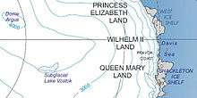
Kaiser Wilhelm II Land (also Wilhelm II Coast) is the part of Antarctica lying between Cape Penck, at 87°43'E, and Cape Filchner, at 91°54'E and is claimed as part of the Australian Antarctic Territory, although this claim is not universally recognized.
The area was discovered on February 22, 1902 during the Gauss expedition (1901-1903), led by Arctic veteran and geology professor Erich von Drygalski. Drygalski named it after Kaiser Wilhelm II[1] who had funded the expedition with 1.2 million Goldmarks.
In the bay where Drygalski's expedition had their camp until February 8, 1903 is Gaussberg, a 370 metre high extinct volcano which was named after the mathematician and physicist Carl Friedrich Gauss.
References
- ↑ "Wilhelm II Coast". Geographic Names Information System. United States Geological Survey. Retrieved 2013-04-12.
![]() This article incorporates public domain material from the United States Geological Survey document "Wilhelm II Coast" (content from the Geographic Names Information System).
This article incorporates public domain material from the United States Geological Survey document "Wilhelm II Coast" (content from the Geographic Names Information System).
Coordinates: 67°0′S 90°0′E / 67.000°S 90.000°E